Andover, Connecticut facts for kids
Quick facts for kids
Andover, Connecticut
|
||
|---|---|---|

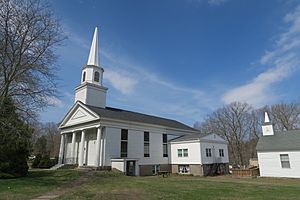
First Congregational Church (2017)
|
||
|
||
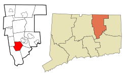
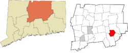
 Tolland County and Connecticut Tolland County and Connecticut |
||
| Country | United States | |
| U.S. state | Connecticut | |
| County | Tolland | |
| Region | Capitol Region | |
| Government | ||
| • Type | Selectman-town meeting | |
| Area | ||
| • Total | 15.7 sq mi (40.7 km2) | |
| • Land | 15.5 sq mi (40.0 km2) | |
| • Water | 0.2 sq mi (0.6 km2) | |
| Elevation | 400 ft (122 m) | |
| Population
(2020)
|
||
| • Total | 3,151 | |
| Time zone | UTC−5 (Eastern) | |
| • Summer (DST) | UTC−4 (Eastern) | |
| ZIP Code |
06232
|
|
| Area code(s) | 860/959 | |
| FIPS code | 09-01080 | |
| GNIS ID | 213382 | |
Andover is a small, quiet town in Connecticut, USA. It is located in the Capitol Planning Region, about 10 miles east of Hartford. In 2020, about 3,151 people lived here.
Contents
History of Andover
Andover became its own town on May 18, 1848. Before that, it was part of two other towns, Hebron and Coventry. The town got its name from a place called Andover in England.
Geography and Nature
Andover covers about 15.7 square miles (40.7 square kilometers). Most of this area is land, with a small part being water. Several small streams and rivers flow through Andover. These include the Hop River, Burnap Brook, Skungamaug River, and Straddle Brook. Andover Lake is also located in the southeastern part of the town.
Andover's Population
| Historical population | |||
|---|---|---|---|
| Census | Pop. | %± | |
| 1850 | 500 | — | |
| 1860 | 517 | 3.4% | |
| 1870 | 461 | −10.8% | |
| 1880 | 428 | −7.2% | |
| 1890 | 401 | −6.3% | |
| 1900 | 385 | −4.0% | |
| 1910 | 371 | −3.6% | |
| 1920 | 389 | 4.9% | |
| 1930 | 430 | 10.5% | |
| 1940 | 560 | 30.2% | |
| 1950 | 1,034 | 84.6% | |
| 1960 | 1,771 | 71.3% | |
| 1970 | 2,099 | 18.5% | |
| 1980 | 2,144 | 2.1% | |
| 1990 | 2,540 | 18.5% | |
| 2000 | 3,036 | 19.5% | |
| 2010 | 3,303 | 8.8% | |
| 2020 | 3,151 | −4.6% | |
| U.S. Decennial Census | |||
Andover's population has grown quite a bit over the years. In 1850, there were only 500 people living here. By 2020, the population had grown to 3,151.
According to the 2010 United States Census, most of the people in Andover were white (about 95.9%). There were also smaller numbers of Black or African American, Native American, and Asian residents. About 1.6% of the population was Hispanic or Latino.
Town Services and Roads
Route 6 is a main road that runs through the middle of Andover. It connects the town to nearby places like Windham and Bolton.
Andover also has a public library. It first opened in 1896 in the Congregational Church. In 1927, the library moved to its current location on Long Hill Road.
Fun Places to Visit
- Andover Veterans Monument Park is a special place to remember people who served in the military. It is located on Monument Lane.
- In this park, there is an Agent Orange Monument. It was put there on June 5, 2021, to remember those who were affected by Agent Orange during the Vietnam War.
- Museum of Andover History is found in the Old Town Hall on Monument Lane. This museum helps visitors learn about Andover's history, going all the way back to the 1600s.
Schools in Andover
Younger students in Andover attend Andover Elementary School. This school teaches children from kindergarten through sixth grade. For older students, grades 7 through 12, they go to the R.H.A.M. middle and high schools.
See also
 In Spanish: Andover (Connecticut) para niños
 | Emma Amos |
 | Edward Mitchell Bannister |
 | Larry D. Alexander |
 | Ernie Barnes |


