Stafford Springs, Connecticut facts for kids
Quick facts for kids
Stafford Springs
|
|
|---|---|

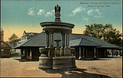
The Holt Memorial Fountain circa. 1910
|
|

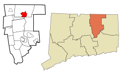
Location in Tolland County and the state of Connecticut
|
|
| Country | |
| State | |
| County | Tolland |
| Region | Capitol Region |
| Town | Stafford |
| Area | |
| • Total | 6.41 sq mi (16.6 km2) |
| • Land | 6.37 sq mi (16.5 km2) |
| • Water | 0.036 sq mi (0.093 km2) |
| Elevation | 607 ft (185 m) |
| Population
(2020)
|
|
| • Total | 11,000 |
| • Density | 1,720/sq mi (660/km2) |
| Time zone | UTC−5 (Eastern (EST)) |
| • Summer (DST) | UTC−4 (EDT) |
| ZIP code |
06076
|
| Area code | 860 |
| FIPS code | 09-72300 |
| GNIS feature ID | 2377866 |
Stafford Springs is a special kind of community in Stafford, Connecticut, United States. It's called a census-designated place, which means it's an area that the government counts for population, but it's not a separate town or city. In 2020, about 4,780 people lived there. Stafford Springs used to be a "borough," which is like a small, self-governing town. But in 1991, it stopped being a borough and became part of the larger town of Stafford.
This community is located near where the Willimantic River begins. Because of the river, many mills were built here a long time ago. These mills became the biggest businesses in the area. Today, you can still see the historic Holt Memorial Fountain and the old railroad station in Stafford Springs.
Contents
The Healing Springs of Stafford
In the 1700s, Stafford Springs was famous for its natural springs. People believed the water from these springs could help cure many illnesses. They thought it could help with things like gout (a type of arthritis) and other health problems.
- A famous visitor to the springs was John Adams.
- He later became the second President of the United States.
- In 1771, when he was a young lawyer, he visited Stafford Springs.
- He stayed for several days to rest and recover from being overworked and worried.
Law Enforcement in Stafford Springs
Stafford Springs has also played a role in keeping the peace. It was once the main office for Station C of the Connecticut State Police. Later, it became the location for the Troop C Barracks, which is like a police station for state troopers.
Roads and Travel
Several important roads pass through or start in Stafford Springs. These roads help people travel to and from the community.
- Connecticut Route 32
- Connecticut Route 190
- Connecticut Route 19
- Connecticut Route 140
Geography of the Area
Stafford Springs covers an area of about 6.41 square miles (16.6 square kilometers). Most of this area is land, about 6.37 square miles (16.5 square kilometers). A very small part, about 0.036 square miles (0.093 square kilometers), is water.
See also
 In Spanish: Stafford Springs para niños
 | John T. Biggers |
 | Thomas Blackshear |
 | Mark Bradford |
 | Beverly Buchanan |

