
Rockville, Connecticut facts for kids
Quick facts for kids
Rockville, Connecticut
|
|
|---|---|
| Village of Rockville | |

Downtown Rockville from Fox Hill in 2015
|
|
| Etymology: "Going to the Rock" | |

Location in Tolland County, then Tolland County's location in Connecticut
|
|
| Country | United States |
| State | Connecticut |
| County | Tolland |
| Region | Capitol Region |
| Town | Vernon |
| Area | |
| • Total | 1.881 sq mi (4.87 km2) |
| • Land | 1.826 sq mi (4.73 km2) |
| • Water | 0.055 sq mi (0.14 km2) |
| Elevation | 367 ft (112 m) |
| Population
(2020)
|
|
| • Total | 7,920 |
| • Density | 4,337/sq mi (1,675/km2) |
| Time zone | UTC-5 (Eastern Time Zone) |
| • Summer (DST) | UTC-4 (Eastern Daylight Time) |
| Postal Code |
06066
|
| Area code(s) | 860 |
| FIPS code | 09-65230 |
| GNIS feature ID | 2377857 |
|
Rockville Historic District
|
|

George Maxwell Memorial Library, photograph from 2006
|
|

Location in Connecticut

Location in the United States
|
|
| Location | Roughly bounded by Snipsic St., Davis Ave., West and South Sts., Rockville, Connecticut |
| Area | 550 acres (220 ha) |
| Architect | Platt, Charles A. et al |
| Architectural style | Greek Revival, Late Victorian, Classical Revival |
| NRHP reference No. | 84001173 |
| Added to NRHP | September 13, 1984 |
Rockville is a community, or "village," located within the town of Vernon in Tolland County, Connecticut, USA. It is officially known as a census-designated place. Rockville is part of the Capitol Planning Region. In 2020, about 7,920 people lived there. Rockville used to be its own city, starting in 1889. However, in 1965, it joined with the town of Vernon.
Contents
Exploring Rockville's Location
Rockville is a small area. It covers about 1.88 square miles (4.87 square kilometers). Most of this area is land, about 1.82 square miles (4.71 square kilometers). A small part, about 0.05 square miles (0.13 square kilometers), is water.
Rockville's Past: A Journey Through Time
How Rockville Began
In 1726, a man named Samuel Grant traded his farm. He received 500 acres (2.0 square kilometers) of land in what is now Rockville. For nearly 100 years, this area didn't have a name.
A special natural feature here is Shenipsit Lake, often called "The Snip." The Snip feeds the Hockanum River. This river flows down 254 feet (77 meters) over 1.5 miles (2.4 kilometers). Farmers used the river's power for many things. They had a grist mill (for grinding grain), a saw mill (for cutting wood), and even a distillery (for making spirits) starting around 1740.
The First Mill: Rock Mill
In 1821, Colonel Francis McLean built the first textile mill in the area. He worked with George and Allyn Kellogg and Ralph Talcott. They built it next to a spot called "the Rock." This "Rock" was a natural dam made of solid stone. It created a high waterfall on the Hockanum River.
McLean built a water-powered mill there, called the "Rock Mill." It might also have been known as the McLean Woolen Factory. By 1823, the mill was fully working. It was 80 feet long and 30 feet wide. It made blue and blue-mix satinet fabric. In 1826, new power looms were added. The mill brought many people to the area. By 1836, the population grew to 440 people. This included 61 families and 89 children under 10 years old.
How Rockville Got Its Name
Mail used to come once a day by stagecoach from Vernon Center. Vernon Center was where people voted and had the post office. In 1837, a notice was put up at the Rock Mill. It asked people to meet and choose a name for the village. The town needed a permanent name to get its own post office.
Some name ideas were:
- Frankfort – to honor Francis McLean, who built the Rock Mill.
- Vernon Falls
- Grantville – to honor Samuel Grant, the first settler.
- Hillborough – because the area is very hilly.
Simon Chapman, who ran a boarding house for mill workers, suggested "Rockville." People often said "Going to the Rock" when they went to the mill. So, Rockville became the official name. However, Rockville didn't get its own post office until 1842.
Discovering Rockville's Historic District
Most of Rockville is part of the Rockville Historic District. This special area was added to the National Register of Historic Places in 1984. It covers over 550 acres (2.2 square kilometers). The district includes 842 buildings and one other structure. You can see different styles of architecture here. These include Greek Revival, Late Victorian, and Classical Revival buildings.
The Kellogg House is one of these historic buildings. It is now used for adult transitional housing.
Around Talcott Park, you can see many Victorian homes. These houses show different styles from the 1800s. They range from early Greek Revival to Gothic Revival and Italianate styles. Mill owners often built their homes in the downtown area. The buildings around Central Park remind us of the wealth from the woolen industry. They also show Rockville's hopes to be a leading city in the 1800s.
Some interesting historic buildings in Rockville include:
- St. Bernard Church
- Memorial Building (now home to the New England Civil War Museum and town offices)
- Old Rockville High School and East School
- Francis T. Maxwell House (also called Maxwell Court)
- Rockville National Bank
- Union Congregational Church
- Citizen's Block
- Rockville Methodist Episcopal Church
- Fitch Block
- George Maxwell Memorial Library
- Kellogg House
- Turn Halle
- Erhardt Linck's Hall
- 70 Village Street
- George Sykes House (first)
- Hockanum Mill
- Saxony Mill
- Springville Mill
- Florence Mill
- Henry Huhnken's Saloon
- New England Yard
- Castle Sunset
- The Tower on Fox Hill
- Maple Street School
Rockville's People: Demographics
In 2010, Rockville had 7,474 people living there. There were 3,292 households. About 26.8% of households had children under 18. The average household had 2.24 people. The average family had 2.98 people.
The population was spread out by age:
- 26.5% were under 20 years old.
- 17.8% were from 20 to 29 years old.
- 19.8% were from 30 to 44 years old.
- 23.9% were from 45 to 64 years old.
- 12.1% were 65 years or older.
The average age was 33.7 years.
The median income for a household was $40,451. For a family, it was $40,714. About 22.6% of the population lived below the poverty line. This included 37.1% of those under 18.
Famous People from Rockville
Many notable people have connections to Rockville:
- Jahine Arnold (born 1973), a former NFL wide receiver.
- Stephen Farrell (1863–1933), a world champion sprinter and coach.
- Stephanie A. Gallagher (born 1972), a United States District Judge.
- Alice Belle Garrigus (1858–1949), an evangelist and founder of a religious organization.
- William Churchill Hammond (1860–1949), an organist and music educator.
- Edward Stevens Henry (1836–1921), a U.S. Congressman.
- Morgan Lewis (1906–1968), a songwriter and Broadway composer.
- Dwight Loomis (1821–1903), a U.S. Congressman.
- Dwight Marcy (1840–1887), a Connecticut State Representative.
- Mary Mattingly (born 1979), a visual artist.
- Ralph Murphy (1895–1967), a film director.
- Stuart J. Murphy (born 1942), a children's book author.
- Kenneth North (1930–2010), a U.S. Air Force brigadier general.
- Bob Pease (1940–2011), an expert in electronic circuit design.
- Charles Phelps (1852–1940), a lawyer and Connecticut's first attorney general.
- Gene Pitney (1940–2006), a famous singer/songwriter and Rock & Roll Hall of Fame member.
- Charles Ethan Porter (1847–1923), an artist.
- Bill Romanowski (1966–present), a former NFL linebacker who graduated from Rockville High School.
- Antoni Sadlak (1908–1969), a U.S. Congressman.
Images for kids
-
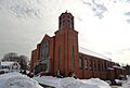
St. Joseph's Church in downtown.
-
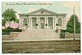
George Maxwell Memorial Library, postcard mailed in 1911.
-
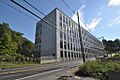
Minterburn Mill after becoming an apartment complex.
-
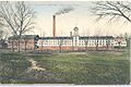
Hockanum Manufacturing Co., around 1909.
-
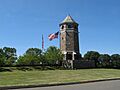
The Tower on Fox Hill, the village's highest peak.
-
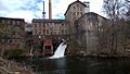
The Hockanum Mill today.


See also
 In Spanish: Rockville (Connecticut) para niños
