
Dam facts for kids
A dam is a big wall or barrier built across a river or stream. Its main job is to stop or slow down the flow of water. This creates a large reservoir or lake behind it. Most dams have a special section called a spillway, which is like a controlled overflow area where water can flow out, either sometimes or all the time.
Dams are mostly built to hold back water. The tallest dam in the world is the Nurek Dam in Tajikistan, which is 300 meters (about 984 feet) high!
History of Dams

The word dam comes from old European languages. People started building dams a very long time ago in places like Mesopotamia and the Middle East. They used dams to control water levels because rivers like the Tigris and Euphrates could be very unpredictable.
The oldest known dam is the Jawa Dam in Jordan, built around 3000 BC. It was a stone wall about 9 meters (30 feet) high.
Ancient Egyptians also built dams, like the Sadd-el-Kafara Dam around 2800 BC. It was meant to control floods but was destroyed during construction. Later, in the 19th century BC, Egyptian pharaohs built dams and canals to link a lake called "Mer-wer" (now Berkat Qaroun) to the Nile River, using it to water nearby lands.
Around 2500 BC, people in Dholavira, India, had a complex water system with 16 reservoirs and dams to collect and store water.
The Romans were great dam builders. They were good at planning big projects and were the first to build large reservoir dams to make sure cities had water all year. They used special waterproof mortar and concrete, which allowed them to build much bigger dams. The Subiaco Dam near Rome was 50 meters (164 feet) high, a record that lasted until 1305 AD! Roman engineers also invented many dam designs we still use today, like arch-gravity dams and buttress dams.
The Kallanai dam in Tamil Nadu, India, built around the 2nd century AD, is one of the oldest water control structures still in use. It diverts water from the Kaveri River to water farms.
In China, the Du Jiang Yan Irrigation System, finished in 251 BC, is the oldest working irrigation system that included a dam.
In Iran, people used bridge dams like the Band-e Kaisar to power water wheels, which helped lift water for towns. Muslim engineers also built "milling dams" to power watermills.
In the Netherlands, a low-lying country, dams were built to block rivers and prevent the sea from flooding marshlands. Many cities, like Amsterdam and Rotterdam, started because of these dams. Amsterdam's main square, Dam Square, is where the original dam was built.
The modern era of large dams began after the Hoover Dam was finished in the United States in 1936. By 1997, there were about 800,000 dams worldwide, with 40,000 of them taller than 15 meters (49 feet).
Types of Dams
Dams can be made by people, by nature, or even by animals like beavers! Human-made dams are usually grouped by their size, what they're used for, or how they're built.
By Structure
Dams are built using different shapes and materials.
Arch Dams

An arch dam is curved, like an arch. Its curved shape helps it push the water's force onto the strong rock walls of a narrow canyon. This design is very strong and uses less material than other types. The Daniel-Johnson Dam in Quebec, Canada, is an example of a multiple-arch dam, which means it has several arches supported by concrete walls.
Gravity Dams

A gravity dam is held in place by its own huge weight. It's so heavy that the force of gravity pulling it down is stronger than the water pushing against it. These dams need a very strong and waterproof foundation. The Grand Coulee Dam in the United States is a solid gravity dam, and the Itaipu Dam is a hollow gravity dam.
Arch-Gravity Dams

An arch-gravity dam combines the strengths of both arch and gravity dams. It uses its curved shape to push some of the water's force onto the canyon walls, and its weight to hold back the rest. This design allows for thinner dams, saving materials. The Hoover Dam is a famous example.
Barrages

A barrage is a special kind of dam with many large gates that can be opened or closed. This allows engineers to control exactly how much water flows through. Barrages are often used to manage water for irrigation or to prevent tides from entering rivers.
Embankment Dams
Embankment dams are built from compacted earth, rock, or a mix of both. Like gravity dams, they rely on their weight to hold back water.
Rock-fill Dams

These dams are made of compacted rocks with a waterproof layer, either on the front face or inside as a "core." If the core is made of clay, it's called a "composite" dam. Rock-fill dams are good at resisting earthquakes. The New Melones Dam in California is a rock-fill dam. Some modern rock-fill dams use asphalt concrete for their core because it's flexible and good in earthquake zones.
Concrete-face Rock-fill Dams (CFRD)
A CFRD is a rock-fill dam with a concrete slab on its upstream (water-facing) side. This concrete slab acts as the waterproof barrier. These dams are flexible, quicker to build, and often cheaper than earth-fill dams. The Shuibuya Dam in China, completed in 2008, is the tallest CFRD in the world.
Earth-fill Dams
Earth-fill dams, also called earthen dams, are simply built from well-packed earth. Some are made of one type of material ("homogeneous"), while others have different layers or "zones," often with a waterproof clay core inside a shell of local material. The Tarbela Dam in Pakistan is the largest earth-filled dam in the world. Because they use local materials, earth-fill dams can be very cost-effective.
By Size
Experts define "large dams" as those taller than 15 meters (49 feet). "Major dams" are even bigger, over 150 meters (492 feet) high.
By Use
Dams serve many important purposes:
- Power Generation: Many dams generate hydroelectric power, which is electricity made from moving water. Water flows through large pipes called penstocks to spin water turbines, which then power electrical generators. This is a major source of clean energy worldwide.
- Water Supply: Dams create reservoirs that store water for cities and towns to drink and use.
- Stabilize Water Flow / Irrigation: Dams help control river flow, making sure there's enough water for farms and irrigation, especially in dry seasons.
- Flood Prevention: Some dams are built specifically to hold back floodwaters, protecting communities downstream.
- Land Reclamation: In some places, dams (often called dikes or levees) are used to keep water out of areas that would otherwise be underwater, allowing that land to be used by people.
- Water Diversion: Smaller dams can redirect water from a river into canals or tunnels for irrigation or power generation.
- Navigation: Dams can make rivers deeper, which helps boats and ships travel more easily.
- Recreation and Beauty: Many reservoirs created by dams become popular spots for boating, fishing, and enjoying nature.
Sometimes, the different uses of a dam can conflict. For example, generating power might require keeping the reservoir high, while flood prevention might require keeping it low. Dam managers have to balance these different needs.
Location
The best place to build a dam is usually a narrow part of a deep river valley, where the valley sides can act as natural walls. Engineers also need to consider things like:
- How easily water can pass through the surrounding rock or soil.
- If there are earthquake faults nearby.
- The risk of landslides.
- The impact on local wildlife, forests, and fish (sometimes fish ladders are built to help fish move past the dam).
- How many people live in the area that will be flooded, and where they will move.
Impact Assessment
Building a dam has both good and bad impacts.
Environmental Impact
Dams change how a river flows. Water released from dams often has less sediment, which can cause the riverbed downstream to erode. Dams can also block fish from swimming upstream to their breeding grounds, harming fish populations. A large dam can even cause the loss of entire ecosystems and rare species, replacing them with a new lake environment.
Large reservoirs can sometimes cause small earthquakes due to the huge weight of the water. Dams can also contribute to global warming by releasing greenhouse gases like methane from decaying plant matter in the reservoirs.
Human Social Impact
Building dams often means that many people have to move from their homes. For example, the Three Gorges Dam in China caused over a million people to be relocated. Many valuable historical sites can also be lost underwater.
Economics
Building a hydroelectric power plant is a very big project that takes a long time to plan and build. It can be expensive at first. However, once a hydroelectric dam is built and well-maintained, it's usually a very cheap and reliable source of electricity because it doesn't need fuel. It's also a clean, renewable energy source.
Dam Failure

When a dam breaks or is badly damaged, it can cause a huge disaster. Engineers constantly monitor dams for any signs of problems. Most dams have ways to lower or even drain the reservoir if there's a serious issue.
The main reasons dams fail include:
- Not having a big enough spillway to handle extreme floods.
- Water leaking through the dam or its foundation.
- Mistakes in design or construction.
- Geological problems like unstable ground or landslides.
- Poor maintenance.
- Extreme rainfall or earthquakes.
A famous example of a dam failure was the Johnstown Flood in Pennsylvania in 1889, caused by an inadequate spillway.
During wars, dams are considered "installations containing dangerous forces" because their destruction could harm many civilians. So, they are protected by international law and should not be attacked if it would cause severe losses among people.
A well-known example of a deliberate dam attack was the "Dambusters" raid by the British Royal Air Force during World War II. They breached three German dams to impact their industry and power supply.
Images for kids
-
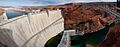
Glen Canyon Dam on the Colorado River, Arizona, USA
-
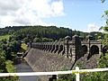
Lake Vyrnwy Dam, Wales, finished in 1888
-
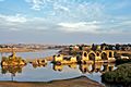
Karapuzha Dam, an earthen dam in the Indian state of Kerala
-
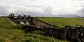
Small dam near Groningen, Netherlands
-
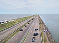
Afsluitdijk with the Wadden Sea (a part of the North Sea) on the left and the IJsselmeer on the right in the Netherlands
-
Remains of the Band-e Kaisar dam, built by the Romans in the 3rd century AD
-
An engraving of the Rideau Canal locks at Bytown
-
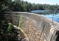
Masonry arch wall, Parramatta, New South Wales, the first engineered dam built in Australia
-
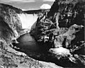
The Hoover Dam by Ansel Adams, 1942
-
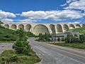
Daniel-Johnson Dam, Quebec, is a multiple-arch buttress dam.
-
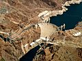
The Hoover Dam is an example of an arch-gravity dam.
-
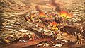
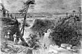
South Fork Dam failure and resulting flood that destroyed Johnstown in Pennsylvania in 1889


_-_30_April_2009.jpg)

See also
 In Spanish: Represa para niños
