
Tasmania facts for kids
Quick facts for kids
Tasmania
lutruwita (palawa kani)
|
||||
|---|---|---|---|---|
|
||||
Nickname(s):
|
||||
| Motto: | ||||
|
Location of Tasmania in Australia
Coordinates: 42°S 147°E / 42°S 147°E |
||||
| Country | Australia | |||
| Before federation | Colony of Tasmania | |||
| Federation | 1 January 1901 | |||
| Named for | Abel Tasman | |||
| Capital
and largest city
|
Hobart 42°52′50″S 147°19′30″E / 42.88056°S 147.32500°E |
|||
| Administration | 29 local government areas | |||
| Demonym(s) |
|
|||
| Government | ||||
|
• Monarch
|
Charles III | |||
|
• Governor
|
Barbara Baker | |||
|
• Premier
|
Jeremy Rockliff (Liberal) | |||
| Legislature | Parliament of Tasmania | |||
| Legislative Council | ||||
| House of Assembly | ||||
| Parliament of Australia | ||||
|
• Senate
|
12 senators (of 76) | |||
| 5 seats (of 151) | ||||
| Area | ||||
|
• Total
|
68,402 km2 (26,410 sq mi) (7th) | |||
| Highest elevation | 1,617 m (5,305 ft) | |||
| Population | ||||
|
• March 2022 estimate
|
||||
|
• Density
|
8.9/km2 (23.1/sq mi) (4th) | |||
| GDP (nominal) | 2020 estimate | |||
|
• Total
|
||||
|
• Per capita
|
||||
| Gini (2016) | 44.8 medium · 3rd |
|||
| HDI (2021) | very high · 8th |
|||
| Time zone | UTC+10:00 (AEST) | |||
|
• Summer (DST)
|
UTC+11:00 (AEDT) | |||
| Postal abbreviation |
TAS
|
|||
| ISO 3166 code | AU-TAS | |||
| Symbols | ||||
| Mammal | Tasmanian devil (Sarcophilus harrisii) |
|||
| Bird | Yellow wattlebird (unofficial) (Anthochaera paradoxa) |
|||
| Flower | Tasmanian blue gum (Eucalyptus globulus) |
|||
| Plant | Leatherwood (unofficial) (Eucryphia lucida) |
|||
| Mineral | Crocoite (PbCrO4) |
|||
| Colour | Bottle Green (PMS 342), Yellow (PMS 114), & Maroon (PMS 194) |
|||


Tasmania (pronounced taz-MAY-nee-uh) is an island state that belongs to Australia. It is located about 240 kilometers (150 miles) south of the Australian mainland. The Bass Strait separates Tasmania from the rest of Australia.
The state includes the main island of Tasmania, which is the 26th largest island in the world. It also has about 1000 smaller islands around it. Tasmania is Australia's least populated state, with about 570,000 people living there as of 2021.
Hobart is the state capital and largest city. About 40% of Tasmania's population lives in the Greater Hobart area. Tasmania is unique because fewer people live in its capital city compared to other Australian states.
The main island of Tasmania was first home to Aboriginal peoples. It is believed that the Aboriginal Tasmanians became separated from mainland Aboriginal groups around 11,700 years ago. This happened when sea levels rose and formed the Bass Strait.
Europeans first settled the island permanently in 1803. It was set up as a penal settlement by the British Empire. This was done to stop the First French Empire from claiming the land during the Napoleonic Wars.
At the time of British settlement, there were an estimated 3,000 to 7,000 Aboriginal people. However, their population greatly decreased within 30 years. This was due to conflicts with settlers, known as the "Black War", and the spread of diseases. The conflict, which was most intense between 1825 and 1831, led to a period of strict rule.
Under British rule, the island was first part of the Colony of New South Wales. But in 1825, it became a separate colony called Van Diemen's Land. This name was given after Anthony van Diemen. Around 80,000 convicts were sent to Van Diemen's Land before this practice stopped in 1853.
In 1855, Tasmania's current laws were put in place. The next year, the colony officially changed its name to Tasmania. In 1901, it joined the federation of Australia and became a state.
Today, Tasmania has the second smallest economy among Australian states and territories. Its main industries are tourism, farming, fishing, education, and healthcare. Tasmania exports a lot of farm products and is a popular place for eco-tourism. About 42% of its land is protected, including national parks and World Heritage Sites. The world's first environmental political party was started in Tasmania.
Contents
Understanding Tasmania's Name
Tasmania is named after Dutch explorer Abel Tasman. He was the first European to report seeing the island on November 24, 1642. Tasman first named the island Anthony van Diemen's Land after his sponsor, Anthony van Diemen. He was the Governor of the Dutch East Indies. The British later shortened the name to Van Diemen's Land. On January 1, 1856, it was officially renamed Tasmania to honor its first European discoverer.
People sometimes called Tasmania "Dervon" in the past. The common nickname for the state is "Tassie". It is also shortened to "Tas", especially in business names and website addresses. "TAS" is also the official postal abbreviation for the state.
In the palawa kani language, which was created from old Aboriginal languages, the main island of Tasmania is called lutruwita. This name comes from the Bruny Island Tasmanian language. Some other Aboriginal names have been officially accepted by the Tasmanian government.
Bilingual Place Names
Many places in Tasmania now have two names, one English and one in palawa kani.
- kanamaluka / Tamar River
- kunanyi / Mount Wellington
- laraturunawn / Sundown Point
- nungu / West Point
- pinmatik / Rocky Cape
- takayna / The Tarkine
- taypalaka / Green Point
- titima / Trefoil Island
- truwana / Cape Barren Island
- wukalina / Mount William
- yingina / Great Lake
Palawa Place Names
Some areas have only palawa kani names:
- larapuna: an area around the Bay of Fires
- Narawntapu National Park (formerly Asbestos Range National Park)
- putalina: an area around Oyster Cove (including the community of Oyster Cove)
Tasmania is also known for its unique and sometimes funny place names. These names often come from old descriptions that have changed meaning over time. Examples include 'Bobs Knobs' or 'Paradise'.
Tasmania's Past: A Journey Through Time

How Tasmania Was Formed
The island of Tasmania was connected to mainland Australia until about 11,700 years ago. This was at the end of the last ice age. Much of the island is made of Jurassic dolerite rock. This rock pushed up through other rock types, forming tall columns. Tasmania has the largest areas of dolerite in the world, creating many unique mountains and cliffs.
The central plateau and southeastern parts of the island are mostly dolerite. Mount Wellington near Hobart is a great example, with its distinct columns called the Organ Pipes.
In the southwest, very old sea sediments formed Precambrian quartzite rocks. These create sharp ridges and ranges, like Federation Peak. In the northeast and east, you can see granite rocks, similar to those on mainland Australia. The northwest and west have volcanic rocks rich in minerals.
The high mountains with quartzite and dolerite show signs of glaciation. Much of Australia's glaciated landscape is found here. The mix of these rock types creates scenery found nowhere else in the world.
Tasmania's First People

Evidence shows that Aboriginal people lived in Tasmania about 42,000 years ago. Rising sea levels separated Tasmania from mainland Australia around 10,000 years ago. By the time Europeans arrived, there were nine main Aboriginal groups in Tasmania.
In 1803, when the British began to settle, the Aboriginal population was estimated to be between 3,000 and 10,000 people. They used fire-stick farming, hunted animals like kangaroos and wallabies, and gathered seafood. They lived as nine separate "nations" on the island, which they called "Trouwunna".
European Explorers Arrive
_(adjusted).jpg)
The first European to see Tasmania was Dutch explorer Abel Tasman on November 24, 1642. He landed at what is now Blackman Bay. Over a century later, in 1772, a French group led by Marc-Joseph Marion du Fresne landed nearby. The next year, Tobias Furneaux was the first Englishman to land in Tasmania at Adventure Bay. Captain James Cook also visited Adventure Bay in 1777.
In 1798–99, Matthew Flinders and George Bass sailed through Bass Strait. They were the first to confirm that Tasmania was an island.
In August 1803, New South Wales Governor Philip Gidley King sent Lieutenant John Bowen to set up a small military base. This was on the eastern side of the Derwent River. The goal was to prevent French explorers from claiming the island. Bowen's group, including 21 male and three female convicts, named their camp Risdon.

A few months later, Captain David Collins started a second settlement. This was 5 kilometers (3 miles) south in Sullivans Cove, on the western side of the Derwent. This spot had more fresh water. This settlement became known as Hobart Town, or Hobart, named after Lord Hobart, the British Colonial Secretary. The Risdon settlement was later abandoned.
The Sullivans Cove settlement faced severe food shortages. By 1806, people were starving, eating seaweed and whale blubber to survive.
A smaller colony was started at Port Dalrymple on the Tamar River in October 1804. Other settlements for convicts were also set up. These included the very harsh ones at Port Arthur and Macquarie Harbour. Tasmania received about 75,000 convicts in total.
By 1819, the Aboriginal and British populations were about equal, with around 5,000 people each. Free settlers began arriving in large numbers from 1820. They were attracted by promises of land and free convict labor. By 1830, one-third of Australia's non-Indigenous population lived in Van Diemen's Land. The island also had about half of all cultivated land and exports in Australia.
Conflicts and Changes
Tensions grew between Tasmania's Aboriginal people and white settlers. This was partly due to more competition for food like kangaroos. Violence increased rapidly from the mid-1820s in what became known as the "Black War". Aboriginal people were desperate due to less food and anger over women and girls being taken. Settlers also attacked to get revenge and control the native population.
In November 1826, Governor Sir George Arthur announced that colonists could kill Aboriginal people if they attacked settlers or their property. In the next eight months, over 200 Aboriginal people were killed. In April 1828, Arthur created a rule forbidding Aboriginal people from entering settled areas without a special pass. Martial law was declared in November that year and lasted for over three years.
In November 1830, Arthur organized the "Black Line". This was a large effort to push Aboriginal people out of settled areas onto the Tasman Peninsula. The plan failed, but by then, Tasmania's Aboriginal population had dropped to about 300.
Relocation of Aboriginal People

After the conflicts ended in 1832, most of the remaining Aboriginal people were moved to Flinders Island. Many became sick with diseases they had no protection against, which further reduced their population. The last person of full Aboriginal Tasmanian descent, Truganini, passed away in 1876.
Becoming a Separate Colony and Changing Its Name

Van Diemen's Land, which was part of New South Wales, became a separate colony on December 3, 1825. Sending convicts to the island stopped in 1853. The colony was renamed Tasmania in 1856. This was partly to show that it was now a society of free settlers, different from its convict past.
Tasmania's new laws were approved in 1855. In 1856, the new parliament met for the first time. This made Tasmania a self-governing colony of the British Empire.
The colony faced ups and downs in its economy but was mostly successful. Tasmania had many good times in the late 1800s, becoming a global center for shipbuilding. It also had a local defense force that helped in the Second Boer War. Tasmanian soldiers won the first two Victoria Crosses given to Australians in that war.
Joining the Australian Nation
In 1901, the Colony of Tasmania joined with the five other Australian colonies. Together, they formed the Commonwealth of Australia. Tasmanians voted strongly in favor of joining the federation.
Tasmania in the 20th and 21st Centuries
Tasmania was the first place in the southern hemisphere to have electric lights. Launceston got them in 1885, and Zeehan in 1900. The state's economy grew with mining until World War I. In 1901, Tasmania had 172,475 people.
In 1910, Hydro Tasmania was founded. This led to major dam projects and shaped how towns developed. In the 1970s, the government planned to flood Lake Pedder, an important natural area. This led to the creation of the world's first green political party, the United Tasmania Group. The campaign against the Franklin Dam in the early 1980s also gained national and international attention.
In 1943, Enid Lyons became the first woman elected to the Australian House of Representatives.
After World War II, many people moved to cities, and towns like Ulverstone grew. Tasmania became known as a "Sanitorium of the South" and a popular place for health-focused tourism. The MS Princess of Tasmania started its first trip in 1959, becoming the first car ferry to Tasmania. In 1968, Tasmania opened Australia's first casino.
Queen Elizabeth II visited in 1954. The 1950s and 60s saw the opening of major public services. These included the Tasmanian Housing Department and Metro Tasmania bus services. A new jail opened in Risdon in 1960, and the State Library of Tasmania opened the same year. The University of Tasmania moved to its current location in 1963.
The state was severely affected by the 1967 Tasmanian fires. Over 652,000 acres burned in just five hours. In 1975, the Tasman Bridge collapsed when a ship hit it. This was the only bridge in Hobart, making it impossible to cross the Derwent River by road in the city.
In the 1980s, environmental concerns grew. The Australian Antarctic Division headquarters were built, and the Tasmanian Wilderness World Heritage Area was created. The federal government stopped the Franklin Dam project in 1983. CSIRO opened its marine studies center in Hobart. Pope John Paul II held a mass at Elwick Racecourse in 1986.
The 1990s focused on LGBT rights in Tasmania. This led to homosexuality being made legal in 1997. Christine Milne became the first female leader of a Tasmanian political party in 1993. Many local councils merged, reducing their number from 46 to 29.
On April 28, 1996, a terrible event known as the Port Arthur massacre occurred. A lone gunman killed 35 people and injured 21 others. This led to an immediate review of firearm laws. New, stricter gun ownership laws were adopted across Australia.
In 2000, Queen Elizabeth II visited again. Gunns, a major forestry company, grew in importance but later closed in 2013. In 2004, Premier Jim Bacon passed away from lung cancer while in office. In January 2011, David Walsh opened the Museum of Old and New Art (MONA) in Hobart. It quickly became Tasmania's top tourist attraction.

The COVID-19 pandemic in Tasmania caused at least 230 cases and 13 deaths by September 2021. In 2020, the Tasmanian government declared a public health emergency. The North-West region had a significant outbreak, needing help from the Federal government. By late 2021, Tasmania was leading Australia in vaccination efforts.
Tasmania's Amazing Geography

Tasmania is Australia's largest island, covering 68,401 square kilometers (26,410 sq mi). It sits directly in the path of the strong "Roaring Forties" winds that blow around the world. To its north, the Bass Strait separates it from mainland Australia. Tasmania is the only Australian state not on the mainland.
About 2,500 kilometers (1,600 miles) south of Tasmania lies the George V Coast of Antarctica. Depending on how ocean borders are defined, Tasmania can be seen as surrounded by the Southern Ocean. Or, it can have the Pacific Ocean to its east and the Indian Ocean to its west.
The southernmost point on mainland Tasmania is South East Cape. The northernmost point is in Woolnorth / Temdudheker near Cape Grim / Kennaook. Tasmania is at similar latitudes to the South Island of New Zealand and parts of Patagonia in South America. In the Northern Hemisphere, it's like Hokkaido in Japan or the north Mediterranean in Europe.

The most mountainous area is the Central Highlands. This covers most of the central western parts of the state. The Midlands, in the central east, are quite flat and used mostly for farming. Tasmania's tallest mountain is Mount Ossa at 1,617 meters (5,305 feet).
Much of Tasmania is still covered in dense forests. The Southwest National Park and nearby areas have some of the last temperate rainforests in the Southern Hemisphere. The Tarkine, in the far northwest, is Australia's largest temperate rainforest. It covers about 3,800 square kilometers (1,500 sq mi).
Because of its rugged landscape, Tasmania has many rivers. Several large rivers have been dammed to create hydroelectricity. Many rivers start in the Central Highlands and flow to the coast. Tasmania's main towns are mostly located around estuaries (river mouths).
Tasmania is shaped like a downward-pointing triangle. It looks like a shield, heart, or face. It includes the main island and at least a thousand smaller islands. The largest of these are Flinders Island, King Island, Cape Barren Island, Bruny Island, Macquarie Island, and Maria Island.
Tasmania has many separate and continuous mountain ranges. Most of the state has a lot of dolerite rock. The western half is older and more rugged. It features buttongrass plains, temperate rainforests, and quartzite ranges like Federation Peak. These mountains cause a rain shadow effect. The western half gets most of the rain, which affects the types of plants that grow there.
The Interim Biogeographic Regionalisation for Australia (IBRA) divides Tasmania into 9 natural regions: Ben Lomond, Furneaux, King, Central Highlands, Northern Midlands, Northern Slopes, Southern Ranges, South East, and West.
.jpg)

Tasmania's Environment and Wildlife
Tasmania's environment has many different natural areas. It is the most forested state in Australia. It protects the country's largest areas of temperate rainforest. A special type of moorland called buttongrass plains is found in the west and southwest. These may have grown larger due to Tasmanian Aboriginal burning practices.
Tasmania also has diverse alpine garden environments, like cushion plants. Highland areas get snow above about 1,000 meters (3,300 feet) every year. Cold air from Antarctica often brings snow down to 800 meters (2,600 feet), and sometimes even lower. This climate supports cypress forests in the Central Plateau and mountains. The Walls of Jerusalem has large areas of rare pencil pine and King Billy pine.
On the West Coast Range, Australia's only winter-deciduous plant, deciduous beech, is found. It forms a low carpet or small trees.
Tasmania has many waterfalls. They can be found in small creeks, alpine streams, fast-flowing rivers, or falling from high cliffs. The most famous waterfall is Russell Falls in Mount Field National Park. It is close to Hobart and has stepped falls totaling 58 meters (190 feet) high.
Tasmania also has many beaches. The longest is Ocean Beach on the West Coast, about 40 kilometers (25 miles) long. Wineglass Bay in Freycinet is a well-known landmark.
The Tasmanian temperate rainforests include several types. These are different from the more common wet sclerophyll forests. However, these eucalypt forests often have rainforest plants and ferns growing beneath them. Rainforests in deep gullies can be hard to walk through due to dense plant growth. Higher-elevation forests are easier to navigate.
The most common rainforests have a 50-meter (160-foot) canopy. Tall eucalyptus trees often grow even higher, providing nesting spots for giant wedge-tailed eagles.
Human activity in Tasmania ranges from urban and industrial areas to farming and grazing land. The Midlands is the most farmed area. It has good soil but is also the driest part of the state.
How Tasmania Became an Island
Captain Abel Tasman might have realized Tasmania was an island when he mapped its coast in 1642. He was sailing north along the east coast. When the land turned northwest, his ships were hit by the strong Roaring Forties winds from the Bass Strait. Tasman was looking for a large southern continent, not more islands, so he turned east.
The next European to enter the strait was Captain James Cook in April 1770. He sailed west into the strait for two hours but turned back. He wrote in his journal that he wasn't sure if Tasmania and New Holland were one land or separate.
The strait was named after George Bass. He and Matthew Flinders sailed through it in 1798–99, proving Tasmania was an island. Governor Hunter officially named the water "Bass's Straits" in 1800. Later, it became known as Bass Strait.
The idea of a strait was first suggested in 1797. A ship's captain reported strong swells, tides, and currents. These suggested that the island was in a channel connecting the Pacific and southern Indian Oceans.
Tasmania's Climate


Tasmania has a cool, mild climate compared to the rest of Australia. It avoids the very hot summers of the mainland and experiences four clear seasons.
- Summer (December to February): The average maximum temperature near the sea is 21°C (70°F). Inland areas like Launceston reach around 24°C (75°F). Other inland areas are much cooler. Liawenee, on the Central Plateau, is one of Australia's coldest places, with temperatures between 4°C (39°F) and 17°C (63°F) in February.
- Autumn (March to May): The weather is mostly calm. Summer weather patterns slowly change to winter ones.
- Winter (June to August): These are generally the wettest and coldest months. Most high areas receive a lot of snow. Winter maximums average 12°C (54°F) along coastal areas and 3°C (37°F) on the central plateau. Inland areas have regular frosts.
- Spring (September to November): This is a changing season. Winter weather patterns begin to shift to summer ones, but snow is still common until October. Spring is usually the windiest time of year, with afternoon sea breezes starting on the coast.
| City/town | Mean min. temp °C | Mean max. temp °C | No. clear days | Rainfall (mm) |
|---|---|---|---|---|
| Hobart | 8.3 | 16.9 | 41 | 616 |
| Launceston | 7.0 | 18.3 | 50 | 666 |
| Devonport | 8.0 | 16.8 | 61 | 778 |
| Strahan | 7.9 | 16.5 | 41 | 1,458 |
Tasmania's Soils

Tasmania's soils are not more fertile than those on mainland Australia. This is because most are heavily leached (nutrients washed away). The driest areas, which have less leaching, were not affected by glaciers or river deposits. Most soils on the Bass Strait Islands, the east coast, and western Tasmania are not very fertile. These lands are not used for farming. However, there is a lot of productive forestry in Tasmania, which is a major industry.
On the north coast, there are some fertile soils used for growing fruit. There are also deep red, easy-to-work soils called "krasnozems" ("red land"). These soils are very acidic but are great for dairy farming, beef cattle, and feed crops.
The Midlands and Lower Derwent areas are different. They have a dry climate and rocky soil. These soils are less leached and contain lime deeper down. They are good for growing pasture, and many sheep are raised here. Some grain crops are also grown in the driest parts. In the river areas of southeastern Tasmania, rich soils allow apples to be grown.
Tasmania became known as the "Apple Isle" because it was once a major apple producer. Apples are still grown in large numbers, especially in southern Tasmania.
Who Lives in Tasmania?

Tasmania's population is quite similar, with most people having British (mainly English) backgrounds. About 65% of its residents are descendants of around 10,000 "founding families" from the mid-1800s.
Tasmania used to be the only state in Australia where women had more than two children on average. By 2012, the birth rate was 2.1 children per woman, which is just enough to replace the population. It still has the second-highest birth rate in Australia.
Major population centers include Hobart, Launceston, Devonport, Burnie, and Ulverstone. Kingston is often seen as part of the Greater Hobart Area.
| Cities and towns by population | ||||||
|---|---|---|---|---|---|---|
| # | Settlement | Population | Metro population |
|||
| 1 | Hobart | 178,009 | 252,669 | |||
| 2 | Launceston | 68,813 | 110,472 | |||
| 3 | Devonport-Latrobe | 30,297 | ||||
| 4 | Burnie-Somerset | 19,385 | ||||
| 5 | Ulverstone | 14,490 | ||||
| 6 | Sorell-Dodges Ferry | 14,400 | ||||
| 7 | Kingston | 10,409 | ||||
| 8 | George Town | 7,117 | ||||
| 9 | Wynyard | 5,990 | ||||
| 10 | New Norfolk | 5,834 | ||||
| 11 | Smithton | 3,881 | ||||
| 12 | Penguin | 3,849 | ||||


| Name | Population |
|---|---|
| Greater Hobart | 226,884 |
| Launceston | 86,404 |
| Devonport | 30,044 |
| Burnie | 26,978 |
| Ulverstone | 14,424 |
Ancestry and Background
| Birthplace | Population |
|---|---|
| Australia | 411,490 |
| England | 18,776 |
| New Zealand | 4,997 |
| Mainland China | 3,036 |
| Scotland | 2,283 |
| Netherlands | 2,193 |
| Germany | 2,108 |
| India | 1,980 |
| United States | 1,630 |
| Philippines | 1,616 |
| South Africa | 1,524 |
| Malaysia | 1,409 |
In the 2016 census, most people said their background was:
- English (47.7%)
- Australian (46.3%)
- Irish (11.7%)
- Scottish (10%)
- Indigenous (4.6%)
- German (3.9%)
- Dutch (2.2%)
- Italian (1.5%)
- Chinese (1.5%)
19.3% of the population was born outside Australia in 2016. The largest groups of people born overseas came from England (3.7%), New Zealand (1%), and Mainland China (0.6%).
4.6% of the population, or 23,572 people, identified as Indigenous Australians (Aboriginal Australians and Torres Strait Islanders) in 2016.
Languages Spoken
In the 2016 census, 88.3% of the population spoke only English at home. Other common languages spoken at home were Standard Mandarin (0.8%), Nepali (0.3%), Greek (0.2%), and Italian (0.2%).
Religious Beliefs
In the 2016 census, the most common religions were Anglicanism (20.4%) and Catholicism (15.6%). However, 37.8% of the population said they had no religion.
Tasmania's Economy and Industries

.jpg)
Historically, Tasmania's main industries have been mining (for copper, zinc, tin, and iron), agriculture, forestry, and tourism. Tasmania is connected to Australia's electrical grid. In the 1940s and 1950s, Hydro Tasmania led a big project to use water power for industry. These industries have changed over time, affecting how people moved to and from the state.
Tasmania also has many food export businesses. These include seafood like salmon, abalone, and crayfish.
In the 1960s and 1970s, traditional crops like apples and pears declined. Other crops and industries eventually took their place. In the 15 years leading up to 2010, new farm products like wine, saffron, and cherries were developed.
Good economic conditions in Australia, cheaper flights, and new Spirit of Tasmania ferries have all helped the tourism industry grow.
About 1.7% of Tasmanians work for local government. Other major employers include Nyrstar, Norske Skog, Grange Resources, Rio Tinto, the Roman Catholic Archdiocese of Hobart, and Federal Group. Small businesses are a big part of the community. These include Incat, Moorilla Estate, and Tassal. In the late 1990s, some national companies put their call centers in Tasmania. This was because they could get cheap access to fast internet connections.
34% of Tasmanians rely on welfare payments as their main income. This is partly because many older residents and retirees in Tasmania receive pensions. Because of its natural beauty and clean air, Tasmania is a popular retirement choice for Australians.
| Industry | AU$ (billions) | % |
|---|---|---|
| Construction | 7.989 | 13.7 |
| Manufacturing | 7.421 | 12.7 |
| Health care & social assistance | 6.303 | 10.8 |
| Agriculture | 5.115 | 8.7 |
| Public administration & safety | 3.572 | 6.1 |
| Transport, postal, & warehousing | 3.269 | 5.6 |
| Financial & insurance services | 3.030 | 5.2 |
| Education & training | 2.794 | 4.8 |
| Electricity, gas, water, & waste services | 2.637 | 4.5 |
| Retail trade | 2.552 | 4.4 |
| Information media & telecommunications | 2.246 | 3.8 |
| Professional, scientific, & technical services | 2.033 | 3.5 |
| Mining | 1.875 | 3.2 |
| Wholesale trade | 1.687 | 2.9 |
| Accommodation & food services | 1.586 | 2.7 |
| Other services | 1.360 | 2.3 |
| Rental, hiring, & real estate services | 1.117 | 1.9 |
| Administrative & support services | 1.045 | 1.8 |
| Arts & recreation services | 0.893 | 1.5 |
| Total industries | $58.523 | 100% |
| Industry | Number | % |
|---|---|---|
| Health care & social assistance | 36,631 | 14.6 |
| Retail trade | 26,290 | 10.5 |
| Education & training | 23,272 | 9.3 |
| Construction | 20,688 | 8.3 |
| Public administration & safety | 20,137 | 8.0 |
| Manufacturing | 18,897 | 7.5 |
| Accommodation & food services | 18,554 | 7.4 |
| Agriculture | 15,021 | 6.0 |
| Professional, scientific, & technical services | 14,097 | 5.6 |
| Transport, postal, & warehousing | 10,691 | 4.3 |
| Other services | 8,739 | 3.5 |
| Administrative & support services | 6,535 | 2.6 |
| Wholesale trade | 6,185 | 2.5 |
| Arts & recreation services | 5,992 | 2.4 |
| Financial & insurance services | 5,248 | 2.1 |
| Electricity, gas, water, & waste services | 4,321 | 1.7 |
| Information media & telecommunications | 3,552 | 1.4 |
| Rental, hiring, & real estate services | 2,990 | 1.2 |
| Mining | 2,780 | 1.1 |
| Total industries | 250,621 | 100% |
Science and Technology in Tasmania
Tasmania's modern scientific sector receives about $500 million in investment each year. Tasmania has a long history of technological innovation. The first scientific observations were made by the First Nation Tasmanians. They watched and created stories about the night sky. Their stories about the phases of the moon and sun are rare because they understood that the moon's light comes from the sun.
The French D'Entrecasteaux Expedition visited Tasmania in 1792–93. They stopped twice at Recherche Bay in far-south Tasmania. During their visit, they made the first botanical, astronomical, and geomagnetic observations in Australia. They also had friendly interactions with the local people and environment.
The Royal Society of Tasmania, founded in 1843, is the longest-running branch of the Royal Society outside the United Kingdom. It was joined by the Tasmanian Society of Natural History in 1849. Early botanists like Ronald Campbell Gunn contributed to its work.
While Tamworth in New South Wales is often credited with having the first electric street lighting in Australia in 1888, Waratah in North West Tasmania actually had it first in 1886, though on a smaller scale.
Tasmanian Culture and Arts
Tasmanian Literature

Many famous books have been written by Tasmanian authors. These include The Museum of Modern Love by Heather Rose and The Narrow Road to the Deep North by Richard Flanagan. Other notable books are The Alphabet of Light and Dark by Danielle Wood and The Roving Party by Rohan Wilson. The Year of Living Dangerously by Christopher Koch is also well-known.
Children's books include They Found a Cave by Nan Chauncy and The Museum of Thieves by Lian Tanner. Tasmania is home to the respected literary magazine Island magazine, started in 1979. It also hosts the biennial Hobart Writers Festival.
Tasmanian Gothic is a special type of literature. It shows the island's unique and mysterious feel compared to mainland Australia. Marcus Clarke's novel For the Term of his Natural Life, set in convict-era Tasmania, is a key example. This unique Gothic style can be seen in all the arts, including painting, music, and architecture.
Visual Arts in Tasmania
The Tasmanian Living Artists' Week is a ten-day festival held every two years for visual artists. In 2007, over 1000 artists took part. Tasmania has two winners of the famous Archibald Prize: Jack Carington Smith in 1963 and Geoffrey Dyer in 2003.
Photographers Olegas Truchanas and Peter Dombrovskis are famous for their photos. These photos became important in the movements to protect Lake Pedder and stop the Franklin Dam. English-born painter John Glover (1767–1849) is known for his paintings of Tasmanian landscapes. The annual Glover Prize is named after him and awarded for the best landscape painting of Tasmania.
The Museum of Old and New Art (MONA) opened in January 2011 in Berriedale. It is the largest privately owned museum in Australia.

Music and Performing Arts

Tasmania has a diverse music scene. It ranges from the Tasmanian Symphony Orchestra, which performs at the Federation Concert Hall, to many small bands and individual artists. Tasmania is also home to talented composers like Constantine Koukias and Maria Grenfell.
IHOS Music Theatre and Opera is one of Australia's leading new music groups. The Southern Gospel Choir is a well-known gospel choir. Famous Australian metal bands Psycroptic and Striborg are from Tasmania.
The Tasmanian Aboriginals had a tradition of singing stories. Fanny Cochrane Smith, the last fluent speaker of any Tasmanian language, made recordings of these songs. Tasmania has also been home to early and important Australian composers. Peter Sculthorpe, originally from Launceston, became famous for his works inspired by his Tasmanian roots.
Amy Sherwin, known as the Tasmanian Nightingale, was a successful soprano singer. Eileen Joyce, from remote Zeehan, became a world-famous pianist.
Tasmanian Cinema
Films set in Tasmania include Young Einstein, The Hunter, and Lion. The Tasmanian landscape is often a key part of these films. The Last Confession of Alexander Pearce and Van Diemen's Land are both set during Tasmania's convict history.
Tasmanian film production dates back to the silent era. The epic For The Term of His Natural Life in 1927 was the most expensive film made in Australia at the time. The Kettering Incident, filmed near Kettering, Tasmania, won an award in 2016. The documentary series Walking with Dinosaurs was partly filmed in Tasmania because of its unique terrain.
Media Outlets
Tasmania has five broadcast television stations that produce local content. These include ABC Tasmania, Seven Tasmania, WIN Television Tasmania, 10 Tasmania, and SBS.
Sports in Tasmania

Sport is a popular activity in Tasmania. The state has produced many famous athletes and hosted major sporting events. The Tasmanian Tigers cricket team has won the Sheffield Shield several times. They play home games at Bellerive Oval in Hobart. This oval is also home to the Hobart Hurricanes and hosts international cricket matches. Famous Tasmanian cricketers include David Boon and former Australian captains Ricky Ponting and Tim Paine.
Australian rules football in Tasmania is the most watched type of football. A Tasmanian team will join the Australian Football League (AFL) in 2028. AFL matches are played at Aurora Stadium in Launceston and Bellerive Oval in Hobart.
Soccer in Tasmania is the most played football code. The statewide league is the NPL Tasmania.
Rugby Union is also played in Tasmania. Ten clubs compete in the statewide Tasmanian Rugby Competition.
Tasmania hosts the professional Moorilla International tennis tournament. It is part of the lead-up to the Australian Open.
The Sydney to Hobart Yacht Race is an annual event. It starts in Sydney on Boxing Day and finishes in Hobart. It is considered one of the toughest yacht races in the world.
In basketball, Tasmania has been represented in the National Basketball League (NBL) by teams like Launceston Casino City and the Hobart Devils. Since the 2021–22 NBL season, Tasmania has the Tasmania JackJumpers. They play home games in Hobart and Launceston. The JackJumpers won their first NBL championship in the 2023–24 season.
Tasmanian Cuisine
Tasmanian Aboriginals had a varied diet. It included native fruits, birds, and kangaroos. Seafood has always been a big part of the Tasmanian diet. This includes shellfish, crayfish, orange roughy, salmon, and oysters.
Tasmania's non-Aboriginal food culture has a unique history. It has grown with many waves of immigration. Traditional Tasmanian foods include scallop pies, which are pies filled with scallops in curry. Curry powder became popular in the 19th century thanks to Keen's Curry. Tasmania also produces and uses wasabi, saffron, truffles, and leatherwood honey.

Today, Tasmania has many restaurants. This is partly due to immigrants and changing food trends. Many vineyards are scattered across Tasmania. Tasmanian beer brands like Boags and Cascade are well-known. King Island is famous for its special cheeses and dairy products.
The Central Cookery Book, written in 1930 by A. C. Irvine, is still popular. Tasmanian food is often unique and has won many awards. For example, the Hartshorn Distillery has won prizes for its Vodka for three years in a row.
Events and Festivals
To attract tourists, the state government supports several annual events. The most famous is the Sydney to Hobart Yacht Race. It starts in Sydney on Boxing Day and usually finishes in Hobart during the Taste of Tasmania. This is an annual food and wine festival.
Other events include the Targa Tasmania rally. This rally attracts drivers from around the world and takes place over five days across the state. Rural events include Agfest, a three-day agricultural show held near Launceston in early May. TastroFest, Tasmania's Astronomy Festival, is held in Ulverstone in early August. The Royal Hobart Show and Royal Launceston Show are held every October.
Music events include the Falls Festival at Marion Bay. This event is held on New Year's Eve. The Festival of Voices is a national singing celebration held each winter in Hobart. MS Fest is a charity music event in Launceston. The Cygnet Folk Festival is one of Australia's most famous folk music festivals. It is held in Cygnet every January. The Tasmanian Lute Festival is an early music event held every two years.
New arts events include the 10 Days on the Island arts festival. MONA FOMA and Dark Mofo are also popular festivals.
The Unconformity is a three-day festival held every two years in Queenstown on the West Coast. Each February, Evandale hosts a penny-farthing championships.
How Tasmania is Seen in Australia
Tasmania is known in Australia and worldwide for its beautiful wildlife, clean water, and fresh air. It is popular for ecotourism. Many Australians choose Tasmania for a "tree-change" or "sea-change" or for retirement. This is because of its mild climate and friendly people. In other parts of the world, Tasmania is seen as being on the opposite side of the planet. It is also known for unique animals like the Tasmanian Devil, made famous by Warner Brothers.
Common Stereotypes
Tasmania sometimes has a reputation in Australia that is not true. This might be based on old stories from colonial times. Because of these stereotypes, Tasmania is often the subject of jokes on the Australian mainland. However, these jokes are now more sarcastic and friendly.
One common sarcastic comment is about Tasmanians supposedly having "two heads". This idea came from some colonists developing goitres due to low iodine in the soil. But as more tourists visit Tasmania, these ideas are changing.
Another common, but untrue, stereotype is about inbreeding. This comes from Tasmania's smaller size compared to the rest of Australia. However, this was not unique to Tasmania during colonial times. Tasmania's convict settlements were very harsh. During European settlement, Tasmania was an important center of power and a major port for the British Empire. This was before other regions grew with mining booms after convict transportation ended in 1853.
Some people in Australia developed a dislike for Tasmania, even if they had never visited. This sometimes led to ideas about Tasmania leaving Australia to "improve" Australia's reputation.
Getting Around Tasmania

Air Travel
Tasmania's main airlines are Jetstar and Virgin Australia. Qantas, QantasLink, and Rex Airlines also fly direct routes to Brisbane, Gold Coast, Melbourne, and Sydney. Major airports include Hobart Airport and Launceston Airport. Smaller airports like Burnie (Wynyard) and King Island have flights to Melbourne. Airlines of Tasmania offers flights within Tasmania.
Antarctica Connection
Hobart, Tasmania, is Australia's main sea link to Antarctica. The Australian Antarctic Division is located in Kingston. Hobart is also the home port for the French ship l'Astrolabe. This ship makes regular trips to the French Southern Territories near Antarctica.
Road Transport

Roads are the main way to travel within Tasmania. Since the 1980s, many of the state's highways have been improved. These include the Hobart Southern Outlet and the Bass Highway.
Public transport is provided by Metro Tasmania bus services, regular taxis, and UBER in urban areas. Redline Coaches, Tassielink Transit, and Callows Coaches provide bus services between towns.
.jpg)
Rail Transport
Rail transport in Tasmania uses narrow-gauge lines. These lines connect the four major population centers and mining and forestry areas. TasRail operates these services. Regular passenger train services stopped in 1977. Now, only freight trains run, but there are tourist trains in some areas, like the West Coast Wilderness Railway. There is a plan to bring back commuter trains to Hobart, but it needs more support.
Shipping and Ferries

Hobart's harbor has a lot of commercial and recreational shipping. The port hosts about 120 cruise ships during the warmer months. Burnie and Devonport on the northwest coast also have ports. Many other coastal towns have small fishing ports or marinas.
The Bass Strait passenger/vehicle ferries connect Tasmania to mainland Australia. These are operated by the Tasmanian government-owned TT-Line. Tasmania is also home to Incat, a company that makes very fast aluminum catamarans.
Images for kids
-
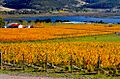
Granton Vineyard in autumn
-
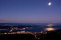
Hobart from kunanyi / Mount Wellington
-
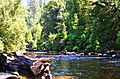
River Styx
-
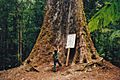
92-metre-high Eucalyptus regnans
-
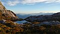
Lake Pedder and Mount Anne from Western Arthurs
-
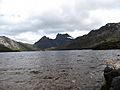
Cradle Mountain from the shore of Dove Lake
-
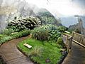
Sub-Antarctic Garden, Royal Tasmanian Botanical Gardens, Hobart


.jpg)


See also
 In Spanish: Tasmania para niños
