Waratah, Tasmania facts for kids
Quick facts for kids WaratahTasmania |
|
|---|---|

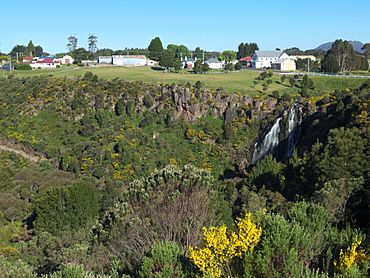
Waratah Falls in Waratah with part of the town in the background
|
|
| Postcode(s) | 7321 |
| Time zone | AEST (UTC+10) |
| • Summer (DST) | AEDT (UTC+11) |
| Location |
|
| LGA(s) | Waratah-Wynyard Council |
| State electorate(s) | Braddon |
| Federal Division(s) | Braddon |
Waratah is a small town in north-western Tasmania, Australia. It is located right next to the Savage River National Park. The town was built to support a tin mine at a place called Mount Bischoff.
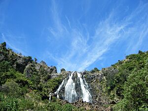
Waratah is special because it sits at the top of a waterfall. Water from the stream was used for the mine. This water helped to wash and process the tin ore. In 2021, about 249 people lived in Waratah. It also made history in 1886. Waratah was the very first town in Australia to have electric street lights!
Contents
History of Waratah
The Discovery of Tin
Tin was found at Mount Bischoff in 1871. A man named James "Philosopher" Smith made this important discovery. At first, the mine worked very well. It produced a lot of tin easily.
Mining Operations
By 1893, the easiest tin ore was gone. So, they stopped using water to wash the ore. Mining continued in other ways. They dug into the side of the mountain from above. They also dug tunnels underground. The underground mine closed in 1914. Surface mining kept going for a while. But it stopped completely in 1929. This happened because the price of tin dropped very low.
War and Reopening
The mine was reopened in 1942. This was during World War II. The Australian government wanted tin to help with the war effort. But the mine finally closed for good in 1947.
Early Electric Lights
The mine was also important for another reason. It generated the power for 400 electric streetlights in 1886. This made Waratah the first town in Australia with electric street lighting.
Post Office and Other Mines
The Mount Bischoff Post Office opened in 1874. It was later renamed Waratah in 1882. Other smaller mines also operated nearby. For example, the Mount Magnet silver mine was connected to Waratah by a tramway. This tramway was about 10 miles south-west of the town.
Waratah's Climate
Waratah has a cool and wet climate. It is known as an oceanic climate. This means it gets a lot of rain. It is also one of the coldest places in Tasmania. Even in summer, the highest temperatures often stay below 10 degrees Celsius.
Winter in Waratah often brings snow. Heavy rainstorms can happen at any time of the year. The temperature has been as high as 32.8 degrees Celsius. It has also dropped as low as -5.5 degrees Celsius. The wettest month ever recorded was May 1923. In that month, Waratah received over 644 millimeters of rain!
| Climate data for Waratah (Mount Road, 1892–2002, rainfall 1882–2019); 609 m AMSL; 41.44° S, 145.53° E | |||||||||||||
|---|---|---|---|---|---|---|---|---|---|---|---|---|---|
| Month | Jan | Feb | Mar | Apr | May | Jun | Jul | Aug | Sep | Oct | Nov | Dec | Year |
| Record high °C (°F) | 32.8 (91.0) |
32.7 (90.9) |
31.7 (89.1) |
23.3 (73.9) |
19.4 (66.9) |
14.4 (57.9) |
12.5 (54.5) |
16.7 (62.1) |
18.5 (65.3) |
25.5 (77.9) |
27.8 (82.0) |
31.7 (89.1) |
32.8 (91.0) |
| Mean daily maximum °C (°F) | 17.6 (63.7) |
18.0 (64.4) |
15.7 (60.3) |
12.5 (54.5) |
9.9 (49.8) |
7.9 (46.2) |
7.2 (45.0) |
7.9 (46.2) |
9.7 (49.5) |
11.8 (53.2) |
13.9 (57.0) |
16.0 (60.8) |
12.3 (54.1) |
| Mean daily minimum °C (°F) | 6.3 (43.3) |
7.0 (44.6) |
5.9 (42.6) |
4.3 (39.7) |
2.8 (37.0) |
1.5 (34.7) |
0.8 (33.4) |
0.9 (33.6) |
1.7 (35.1) |
2.7 (36.9) |
3.8 (38.8) |
5.2 (41.4) |
3.6 (38.5) |
| Record low °C (°F) | −0.2 (31.6) |
0.0 (32.0) |
−1.7 (28.9) |
−3.9 (25.0) |
−5.5 (22.1) |
−4.7 (23.5) |
−5.0 (23.0) |
−5.0 (23.0) |
−3.9 (25.0) |
−5.0 (23.0) |
−3.9 (25.0) |
−0.6 (30.9) |
−5.5 (22.1) |
| Average rainfall mm (inches) | 108.6 (4.28) |
91.9 (3.62) |
122.5 (4.82) |
170.1 (6.70) |
217.5 (8.56) |
224.1 (8.82) |
250.0 (9.84) |
255.7 (10.07) |
224.6 (8.84) |
197.6 (7.78) |
161.2 (6.35) |
139.0 (5.47) |
2,162.8 (85.15) |
| Average rainy days (≥ 0.2mm) | 15.3 | 13.0 | 17.4 | 20.1 | 23.0 | 22.5 | 24.8 | 24.8 | 23.3 | 21.9 | 18.7 | 17.4 | 242.2 |
| Source: Bureau of Meteorology | |||||||||||||
 | James Van Der Zee |
 | Alma Thomas |
 | Ellis Wilson |
 | Margaret Taylor-Burroughs |


