
Launceston, Tasmania facts for kids
Quick facts for kids LauncestonTasmania |
|||||||||||||||
|---|---|---|---|---|---|---|---|---|---|---|---|---|---|---|---|
|
|
|||||||||||||||

Flag
|
|||||||||||||||

Launceston
Location in Tasmania
|
|||||||||||||||
| Population | 90,953 (2021) (21st) | ||||||||||||||
| • Density | 208.895/km2 (541.04/sq mi) | ||||||||||||||
| Established | 1806 | ||||||||||||||
| Postcode(s) | 7250 | ||||||||||||||
| Elevation | 15 m (49 ft) | ||||||||||||||
| Area | 435.4 km2 (168.1 sq mi)(2011 urban) | ||||||||||||||
| Time zone | AEST (UTC+10) | ||||||||||||||
| • Summer (DST) | AEDT (UTC+11) | ||||||||||||||
| Location |
|
||||||||||||||
| LGA(s) | City of Launceston | ||||||||||||||
| Region | North-east | ||||||||||||||
| County | Cornwall | ||||||||||||||
| State electorate(s) | |||||||||||||||
| Federal Division(s) | |||||||||||||||
|
|||||||||||||||
|
|||||||||||||||
.JPG)
.JPG)

.JPG)

.JPG)
Launceston is a city in the north of Tasmania, Australia. It sits where the North Esk and South Esk rivers meet to form the Tamar River. In 2021, about 90,953 people lived in the Launceston urban area. It is the second-largest city in Tasmania, after the capital city, Hobart.
Europeans first settled Launceston in March 1806, making it one of Australia's oldest cities. It has many historic buildings. Like many places in Australia, it was named after a town in the United Kingdom, Launceston, Cornwall. Launceston was also the first place in the Southern Hemisphere to use anaesthetic. It was the first Australian city to have underground sewers. Plus, it was the first Australian city to be lit by hydroelectricity. The city has a maritime climate with four clear seasons. Summers are warmer here than in the south of Tasmania.
Contents
History of Launceston

_-_Copy.jpg)
The first people to live in the Launceston area were Aboriginal Tasmanians. They were largely nomadic and belonged to the Northern Midlands Nations.
The first European explorers, George Bass and Matthew Flinders, arrived in 1798. They were exploring to see if Tasmania was an island. They first landed at Port Dalrymple, which is about 40 kilometers north-west of where Launceston is now.
The first important European settlement in the area began in 1804. Lieutenant Colonel William Paterson and his soldiers set up a camp near George Town. The settlement moved a few times before settling where Launceston stands today.
The settlement was first called Patersonia. However, Paterson later changed the name to Launceston. He did this to honor the Governor of New South Wales, Captain Philip Gidley King, who was born in Launceston, Cornwall.
The Aboriginal Tasmanian Letteremairrener people lived in the area where Launceston is now. They used the Tamar Valley region for thousands of years. They were hunter-gatherers, moving between different areas for food during the seasons. Early interactions between the Letteremairrener people and colonists were complex. Conflicts increased between 1827 and 1831 during a period known as the Black War.
By 1827, Launceston's population grew to 2,000 people. The town became a center for exporting goods, especially from the northern farming areas.
Ships from Launceston were important for sealing and whaling in the early 1800s. They also helped with the Foundation of Melbourne.
New sports like cricket and football became popular as Launceston grew. The Northern Tasmanian Cricket Association Ground was improved in the 1860s. Tasmania played Victoria in Australia's first first-class cricket match there in 1851.
In 1871, tin was found at Mount Bischoff. This started a mining boom. Gold mining also began nearby in Beaconsfield in 1877. Launceston grew from a small town to a city during these years. In 1889, Launceston became the second city in Tasmania, after Hobart.
Population of Launceston
According to the 2021 census, Launceston has a population of 76,849 people. It is the 21st most populated city in Australia.
- About 3.5% of the population are Aboriginal and Torres Strait Islander people.
- Most people (79.2%) were born in Australia. Other common birthplaces include England (2.9%), Nepal (1.6%), and India (1.5%).
- Most people (85.1%) speak only English at home. Other languages include Nepali (2.3%) and Mandarin (1.2%).
- Many people (47.9%) reported having no religion. The most common religions were Anglican (13.8%) and Catholic (12.1%).
City of Gastronomy
In 2021, Launceston was named a UNESCO City of Gastronomy. This means it is globally recognized for its amazing food culture.
Geography of Launceston


Launceston is located in the Tamar Valley in Northern Tasmania. This valley was shaped by volcanoes and glaciers over 10 million years ago.
The city is about 45 kilometers south of the Bass Strait. Its closest neighbor-city is Devonport, about 99 kilometers to the north-west.
Launceston has both steep hills and low-lying areas. Some parts of the suburbs of Inveresk and Invermay are even below high-tide level. Because of this, some areas can have landslip problems or flooding. The shape of the valley can also trap air pollution.
However, the city's air quality has improved since the 1990s. Studies show that wood smoke causes most of the air pollution in winter.
Launceston is where the South Esk River and the North Esk River meet. They form the Tamar River estuary. This river is used for boats and shipping. The main port for Launceston is now at Bell Bay, about 40 kilometers downstream. The South Esk River is the longest river in Tasmania. It flows through many towns before reaching Launceston. The North Esk River also flows to Launceston. Water from the St Patrick's River, a tributary of the North Esk, provides most of Launceston's drinking water.

Flooding and Levee System

Since the 1960s, parts of Launceston have been protected by levees, which are like walls up to 4 meters high. This is because large areas of Invermay and Newstead are on a flood plain. The last big flood was in 1929, which caused a lot of damage and left many people without homes. Since then, there have only been small floods. In 2016, the Tamar River flooded again, causing widespread flooding in low-lying areas.
Climate of Launceston
Launceston has an oceanic climate with mild to warm, somewhat dry summers and cool, damp winters. The city is in the Tamar Valley, surrounded by hills. This means the weather can change quickly.
The warmest months are January and February, with average temperatures from 12.2 to 24.4 °C. The highest temperature ever recorded was 39.0 °C on January 30, 2009.
Winters are cool, with temperatures often dropping below 2 °C. July is the coldest month, with average temperatures from 2.2 to 12.5 °C. The lowest temperature ever recorded was -5.2 °C on July 21, 1991. Snow rarely falls in Launceston.
Because of the valley, Launceston winters are known for foggy mornings. Launceston Airport is one of the foggiest airports in Australia. The average yearly rainfall is 665 mm.
| Climate data for Launceston (1991–2020 normals, extremes 1980–present) | |||||||||||||
|---|---|---|---|---|---|---|---|---|---|---|---|---|---|
| Month | Jan | Feb | Mar | Apr | May | Jun | Jul | Aug | Sep | Oct | Nov | Dec | Year |
| Record high °C (°F) | 39.0 (102.2) |
34.4 (93.9) |
33.5 (92.3) |
27.7 (81.9) |
22.9 (73.2) |
18.4 (65.1) |
18.4 (65.1) |
20.3 (68.5) |
24.8 (76.6) |
28.7 (83.7) |
30.7 (87.3) |
34.1 (93.4) |
39.0 (102.2) |
| Mean daily maximum °C (°F) | 24.8 (76.6) |
24.6 (76.3) |
22.7 (72.9) |
18.9 (66.0) |
15.8 (60.4) |
13.3 (55.9) |
12.8 (55.0) |
13.8 (56.8) |
15.7 (60.3) |
18.2 (64.8) |
20.6 (69.1) |
22.7 (72.9) |
18.7 (65.6) |
| Daily mean °C (°F) | 18.7 (65.7) |
18.6 (65.5) |
16.5 (61.7) |
13.2 (55.8) |
10.4 (50.7) |
8.1 (46.6) |
7.7 (45.9) |
8.7 (47.7) |
10.5 (50.9) |
12.6 (54.7) |
14.9 (58.8) |
16.8 (62.2) |
13.1 (55.5) |
| Mean daily minimum °C (°F) | 12.6 (54.7) |
12.5 (54.5) |
10.3 (50.5) |
7.5 (45.5) |
5.0 (41.0) |
2.9 (37.2) |
2.5 (36.5) |
3.5 (38.3) |
5.2 (41.4) |
7.0 (44.6) |
9.1 (48.4) |
10.9 (51.6) |
7.4 (45.3) |
| Record low °C (°F) | 2.5 (36.5) |
3.4 (38.1) |
0.5 (32.9) |
−1.5 (29.3) |
−3 (27) |
−4.9 (23.2) |
−5.2 (22.6) |
−3.5 (25.7) |
−2.4 (27.7) |
−1.4 (29.5) |
−2.0 (28.4) |
2.0 (35.6) |
−5.2 (22.6) |
| Average rainfall mm (inches) | 51.5 (2.03) |
35.2 (1.39) |
38.8 (1.53) |
51.2 (2.02) |
63.1 (2.48) |
66.9 (2.63) |
78.6 (3.09) |
83.8 (3.30) |
65.6 (2.58) |
48.3 (1.90) |
52.8 (2.08) |
47.6 (1.87) |
684.1 (26.93) |
| Average rainy days (≥ 1 mm) | 4.8 | 4.6 | 4.4 | 6.5 | 7.6 | 8.3 | 9.8 | 10.9 | 10.0 | 7.6 | 7.0 | 6.0 | 87.5 |
| Average afternoon relative humidity (%) | 48 | 49 | 48 | 56 | 63 | 69 | 69 | 63 | 60 | 53 | 53 | 48 | 57 |
| Average dew point °C (°F) | 10.6 (51.1) |
11.1 (52.0) |
9.2 (48.6) |
8.4 (47.1) |
7.5 (45.5) |
6.4 (43.5) |
5.9 (42.6) |
5.4 (41.7) |
6.0 (42.8) |
6.8 (44.2) |
8.4 (47.1) |
9.1 (48.4) |
7.9 (46.2) |
| Mean monthly sunshine hours | 285.2 | 256.9 | 241.8 | 198.0 | 155.0 | 135.0 | 142.6 | 170.5 | 201.0 | 254.2 | 267.0 | 282.1 | 2,589.3 |
| Percent possible sunshine | 62 | 66 | 63 | 60 | 51 | 49 | 48 | 52 | 57 | 62 | 62 | 60 | 59 |
| Source 1: Bureau of Meteorology (1991–2020 averages; extremes 1980–present) | |||||||||||||
| Source 2: Bureau of Meteorology, Launceston Airport (1981–2004 sunshine hours) | |||||||||||||
Architecture in Launceston

Many buildings in Launceston's city center were built in the 1800s and early 1900s. You can see many Federation style houses. The city has well-preserved Victorian and Georgian buildings. There are also many art-deco buildings. These different styles give the city a special old-world feel.
Building rules are strict in the city center. This is to keep the historic look. Most buildings are less than five stories tall.
How Launceston is Governed
Most of Launceston is managed by the City of Launceston local government area. Some outer suburbs are part of nearby councils, like West Tamar Council or Meander Valley Council.
The Launceston City Council holds its meetings in the Launceston Town Hall. The head of the council is called the Mayor. The current mayor is Matthew Garwood, elected in 2023.
For state elections, Launceston is part of the Paterson, Windermere, and Rosevears areas. For national elections, it is in the Division of Bass.
Launceston City Flag
The Launceston flag is based on the city's Coat of Arms, which was given in 1957. You can see the flag flying at places like the Brisbane Street Mall and the Council Chambers.
The flag has three lines that cross each other. These lines stand for the city's three rivers: the North Esk, South Esk, and Tamar. The two rectangles in the lines represent tin ingots, because Launceston used to be a big tin-smelting center. The green strip at the top with a jagged edge shows the city's parks, gardens, and countryside. The Waratah flowers at the top represent all the beautiful flowers in nature. The small circle where the rivers meet is Launceston itself.
Economy and Tourism
Launceston is a main shopping center for northern Tasmania. It is also a big service center for the region. The city has a campus of the University of Tasmania, including the Australian Maritime College. It also has some mining and manufacturing.
Launceston is important for farming and agriculture in the area. While apples were once key, now viticulture (grape growing for wine) is important. High-quality wool is also a big part of the economy.
Tourism in Launceston

Launceston is becoming a popular place for tourists. More visitors come to the city each year. The Cataract Gorge is Launceston's biggest tourist attraction. It is very close to the city center. It has the longest single-span chairlift in the world, which goes 308 meters across the gorge.
Launceston has many parks, like City Park in the city center. City Park is home to the Albert Hall. It also has an area for Japanese macaque monkeys, which were a gift from its sister city, Ikeda, Japan. The Launceston General Post Office is a historic building from the 1880s. Its clock tower chimes every 15 minutes, all day and night. The Tasmania Zoo, known for helping Tasmanian devils, is also near the city.
Culture and Sports
Arts and Entertainment
Launceston's Queen Victoria Museum and Art Gallery opened in 1891. It is now the largest museum outside a capital city in Australia. It has two locations: the original building at Royal Park and another at the Inveresk Cultural Precinct. The Inveresk area also has the Launceston Tramway Museum.

The Country Club Casino is a hotel, casino, and golf course in the suburb of Prospect. It was one of the first casinos in Australia.
Launceston Aquatic is a modern swimming center that opened in 2009. It is just outside the city center.
Launceston hosts the Junction Arts Festival every year. This festival lasts five days and features music, dance, visual art, short films, and live performances.

Sports in Launceston

Sports are very popular in Launceston. Like most of Tasmania, cricket and Australian rules football are favorites. Two famous Australian cricketers, Ricky Ponting and David Boon, were born here. The first first-class cricket match in Australia was played at the Northern Tasmania Cricket Association Ground in 1851.
Australian rules football is very popular and is often played at York Park (University of Tasmania Stadium). This stadium can hold 20,000 people, more than any other stadium in Tasmania. The Hawthorn Football Club plays some of its AFL matches here each year. York Park also hosts concerts and other events.
Association football (soccer) is also played in Launceston. A-League teams have played pre-season games here.
Rugby league is played at junior and senior levels. The Launceston Warriors play in the Tasmanian Rugby League.
Since 2004, the V8 Supercars (Tasmanian Challenge) race has been held yearly at the Symmons Plains Raceway, about 30 km south of Launceston.
The city also has basketball and hockey. In 2009, Launceston opened a new swimming center called Launceston Aquatic.
Media in Launceston
Launceston's local newspaper, The Examiner, started in 1842 and is still published today.
The city has four free TV channels: two from the Australian Broadcasting Corporation (ABC), Special Broadcasting Service (SBS), and two commercial stations (Southern Cross Seven and WIN). There are also many digital-only channels.
Radio stations include LAFM, Chilli FM, Triple J, and ABC Northern Tasmania. There are also community and Christian radio stations.
City Infrastructure
Education in Launceston
- The University of Tasmania has its second-largest campus in Launceston. It is moving a big part of its campus to Inveresk.
- TasTAFE has two main locations in Launceston, offering vocational training.
Utilities in Launceston


Launceston gets most of its electricity from hydro electric power plants. This includes the Trevallyn Power Station, which gets water from Trevallyn Dam. The main electricity company is Aurora Energy.
Historically, Launceston used gas for power. The Duck Reach Power Station started providing electricity in 1895. It was the first power station owned by a city in the Southern Hemisphere. It supplied most of Launceston's power until the 1950s.
Launceston's water comes from the Launceston Water Catchment. Most of it comes from the St Patricks River. The main water company is Ben Lomond Water.
Many companies provide mobile phone and wireless internet services in Launceston. In 2016, Launceston became the first city in Tasmania to be fully connected to the National Broadband Network (NBN).
Transport in Launceston

Roads in Launceston
Cars are the most common way to get around Launceston. The city has 721 km of roads. Many streets in the city center are narrow and one-way.
Since 1998, Launceston has had a public bus service called Metro Tasmania. Redline Coaches also offers school services and trips to other places in Tasmania.
Launceston is a hub for five of Tasmania's main highways. The Midland Highway goes to Hobart. The Bass Highway goes to Devonport and Burnie. The Tasman Highway is another route to Hobart.
Tram and Rail Network

Launceston used to have a tram system. It started in 1909 and had 29 trams. Later, the city started using trolleybuses, especially for hilly routes. The tram network was removed in 1952 to make more room for cars and buses. Today, only a tramway museum in Inveresk remains.
Tasmania also had a passenger rail system, and Launceston was a major hub. However, it closed in 1978.
Launceston Airport
The city has a small airport called Launceston Airport, about 15 km south-east of the city. It serves over one million passengers each year. Airlines like Jetstar, QantasLink, Sharp Airlines, and Virgin Australia fly from here. You can fly directly to Melbourne, Sydney, and Brisbane.
There is also a freight rail system that connects Launceston to Burnie, Hobart, and Bell Bay.
Port of Launceston
Launceston's port is about 48 kilometers north on the Tamar River at Bell Bay. The Port of Bell Bay handles about 5.3 million tons of cargo each year. It has five piers for cruise and passenger ships. The port is next to an industrial area with many companies.
Sister Cities
Launceston has three sister cities around the world.
| City | State | Country | Year |
|---|---|---|---|
| Ikeda | 1 November 1965 | ||
| Napa | 6 June 1988 | ||
| Taiyuan | 28 November 1995 |
Notable People from Launceston
Here are some well-known people who are from or have lived in Launceston:
- Nathaniel Atkinson, a footballer
- Marcos Ambrose, a NASCAR driver
- Simon Baker, an actor
- George Bailey, a cricketer
- Lance Barnard, a former Deputy Prime Minister of Australia
- David Boon, a cricketer
- Harry Cooper, a TV veterinarian
- James Faulkner, a cricketer
- Sir Wilmot Hudson Fysh, who founded Qantas
- Daniel Ganderton, a jockey
- Daniel Geale, a boxer
- Simon Hanselmann, a cartoonist
- Simon Hussey, a songwriter and music producer
- Ray Martin, a journalist
- Stewart McSweyn, a distance runner
- Ricky Ponting, a cricketer
- Richie Porte, a professional cyclist
- Bec Rawlings, a boxer
- Peter Sculthorpe, a composer
- Rachael Taylor, an actress
- Ariarne Titmus, an Olympic champion swimmer
- Shane Yost, a Championship Vert Skater
- Fiora Cutler, a Musician
Images for kids
-
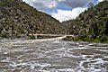
Cataract Gorge during 2003 Flood
See also
 In Spanish: Launceston (Tasmania) para niños
