
Cataract Gorge facts for kids
Quick facts for kids Cataract Gorge |
|
|---|---|
| The Gorge | |

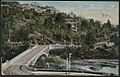
Alexandra Suspension bridge at Cataract Gorge's First Basin
|
|
| Geography | |
| Country | Australia |
| State | Tasmania |
| Municipality | Launceston |
The Cataract Gorge is an amazing river gorge located in Launceston, Tasmania, Australia. It's only about 1.5 kilometers from the city center. This beautiful natural spot is one of the most popular places for tourists to visit in the region. You can find it where the South Esk River flows.
Contents
Discovering Cataract Gorge
The very first European person known to visit Cataract Gorge was William Collins. He found its entrance way back in 1804.

A special path, called the King’s Bridge-Cataract Walk, runs along the north side of the gorge. Volunteers first built this path in the 1890s. It's still a very popular place for people to walk and explore today. Near King's Bridge, on the northern edge of the gorge, you can still see the old toll house. This is where people used to pay a small fee to enter the walking path.
The Famous Chairlift
One of the most exciting things at the gorge is the chairlift. It holds a world record! It's the longest single-span chairlift on Earth. Its longest section stretches for an incredible 308 meters (about 1,010 feet). The chairlift was built in 1972 and has a total length of 457 meters (about 1,499 feet).
Floods and Power
Before the Trevallyn Dam was built in the 1950s, the river in the gorge could flood very high. Sometimes, the water would rise as much as 12 meters (about 39 feet)!
There used to be a power station called Duck Reach. It was about 2.5 kilometers (1.5 miles) from a suspension bridge built in 1940. The power station was washed away in big floods in 1929. It was rebuilt, but then stopped being used when the Trevallyn Dam was finished in 1955. Today, the old power station building is a museum where you can learn about its history.
What You Can See and Do
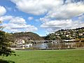
The First Basin is on the southern side of the gorge. It's a fun place with lots to do!
- There's a swimming pool where you can cool off.
- You can ride the famous chairlift across the gorge.
- There are two cafés where you can grab a snack or a drink.
- A funicular railway can take you up and down the hill.
- There's also a big open area surrounded by natural bushland.
At the bottom of the funicular railway, you'll find a small cottage. Inside, it has old photographs and paintings of the basin and the gorge.
The Basin's Depth
For a long time, people told many stories about how deep the First Basin was. Some locals even thought it was a bottomless pit or a volcanic plug! There was even a myth that a submarine tried to find the bottom in the 1960s but ran out of cable.
The truth is, the basin was formed by natural erosion. This happened where two cracks in the Earth, called faults, met. The rock there was weaker, so the river wore it away, creating the basin. In 2016, measurements showed that the deepest part of the basin is 20.5 meters (about 67 feet).
Cliff Grounds and More
On the northern side of the gorge, you'll find the Cliff Grounds. This area is a beautiful Victorian-style garden. It's filled with lovely ferns, unusual plants, and even peacocks roaming around! There are also facilities for visitors to enjoy.

Further upstream is the historic Duck Reach Power Station, which is now an Interpretation Centre. The Launceston City Council first built this power station in 1893. It was the biggest hydro-electric power system of its time! By 1895, it was providing electricity to light up the city.
Exciting Activities
Besides walking and relaxing, there are other exciting things to do at Cataract Gorge:
- You can take a boat cruise along the accessible part of the river.
- Try a thrilling cable hang gliding experience that lets you soar 200 meters (about 656 feet) from a cliff top.
- If you're adventurous, you can even go rock climbing!
Before the Trevallyn Dam was built, there were three smaller basins upstream from the "First Basin." Two of them can still be seen on a map, but the fourth one is now covered by the waters of Lake Trevallyn.
At the lower end of the gorge, the South Esk River flows into the Tamar River. It passes under King's Bridge and another modern bridge. For almost 100 years, King's Bridge was the only way to cross the river north out of the city.
This part of the river is also famous for its exciting whitewater. It's known as a world-class spot for kayaking. Thanks to Hydro Tasmania, a special race is usually held here in late January.
Gallery
-
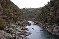
Picture of Cataract Gorge taken from the suspension bridge
-
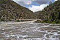
South Esk River in flood at the Gorge
-
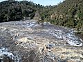
South Esk River in flood at the Gorge, August 2009
-
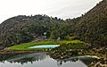
View of first Basin
-
King's Bridge
-
View of Cataract Gorge


