Lilydale, Tasmania facts for kids
Quick facts for kids LilydaleTasmania |
|
|---|---|

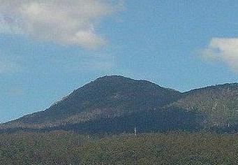
Mount Arthur, Lilydale
|
|
| Population | 695 (2021 census) |
| Postcode(s) | 7268 |
| Location |
|
| LGA(s) | City of Launceston |
| State electorate(s) | Bass |
| Federal Division(s) | Bass |
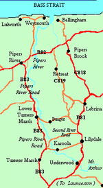
Lilydale, once called Upper Piper, is a small town in northern Tasmania, Australia. It's about 28 kilometers (17 miles) northeast of Launceston. Most of Lilydale is part of the Launceston area.
The town is close to Mount Arthur. In 2016, Lilydale had 277 people living there. Some cool places to visit include the Lilydale Falls, which are two small waterfalls. You can also see Mount Arthur. Along the main street, you'll find telegraph poles painted with fun murals.
Contents
Discovering Lilydale's Past
Lilydale got its new name in 1887. Before that, it was known as Upper Piper. People think the town was renamed because of the many beautiful Christmas lilies growing in the area.
Local records from 1944 show why the name changed. A man named Mr. E Kowarzic suggested calling it Lilydale. This was because churches in the area always had lovely Christmas lilies for special services. Some people wanted to call it 'Tankerville' instead. They worried that letters might get sent to the wrong town, as there was already a Lilydale in Victoria.
The Upper Pipers River Post Office first opened on December 1, 1873. It was officially renamed Lilydale in 1887, along with the town.
Fun Things to Do in Lilydale
Lilydale, along with nearby Karoola and Turners Marsh, is on an old railway line. This line connected Launceston to Scottsdale. It first opened on September 9, 1889.
As of 2017, Lilydale has a team for Australian rules football. It also has a bowls team, which is a bit like lawn bowling. The town has a swimming pool too, open at certain times of the year.
More recently, Lilydale has become known for the Lilydale Village Market. This market started in 2008. It brings people together and offers local goods.
Exploring Nearby Places
Karoola: Fresh Water Area
Karoola, Tasmania is a small place about 6 kilometers (3.7 miles) from Lilydale. It's located off Pipers River Road. The name Karoola means "fresh water" in the local Aboriginal language.
In Karoola, you can find a telephone box and an emergency fire shed. There's also a Catholic church, a tennis court, and a community hall. The local fire station is a bit further away, in Turners Marsh. Karoola used to have a general store, but it's now privately owned.
Underwood: River Views
Underwood, Tasmania is another area just outside Lilydale. The Pipers River flows right through this locality. It's a peaceful place with natural beauty.
Hollybank Forest: Nature's Playground
Hollybank Forest is a large nature reserve, covering 140 hectares (346 acres). It's located on the Pipers River, near Underwood, about 5 kilometers (3.1 miles) from Lilydale. This forest was once used to get timber for sawmills.
Since the land wasn't good for farming, Forestry Tasmania took over managing it. Today, Hollybank Forest offers a few short walking trails. It also has a nice picnic area where you can relax and enjoy nature.
Lower Turners Marsh: Rural Life
Lower Turners Marsh, Tasmania is a place between Lilydale and Launceston. It's found on Pipers River Road. This area is mostly made up of farms and homes in the countryside. Sometimes, Lower Turners Marsh is also called Karoola.
Turners Marsh: Bushland and Karts
Turners Marsh, Tasmania is another locality on Pipers River Road. It's southwest of Lilydale and south of Lower Turners Marsh. A lot of Turners Marsh is bushland, with some small farms mixed in. Turners Marsh is also home to a karting track, which is a fun place for racing small vehicles.
 | Dorothy Vaughan |
 | Charles Henry Turner |
 | Hildrus Poindexter |
 | Henry Cecil McBay |


