Scottsdale, Tasmania facts for kids
Quick facts for kids ScottsdaleTasmania |
|||||||||
|---|---|---|---|---|---|---|---|---|---|

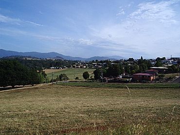
Scottsdale, from North Scottsdale; Mount Barrow can be seen in the background
|
|||||||||
| Postcode(s) | 7260 | ||||||||
| Elevation | 198 m (650 ft) | ||||||||
| Location |
|
||||||||
| LGA(s) | Dorset Council | ||||||||
| State electorate(s) | Bass | ||||||||
| Federal Division(s) | Bass | ||||||||
|
|||||||||
Scottsdale, once called Ellesmere, is a town in the north-east of Tasmania, Australia. It is located on the Tasman Highway. The town is about 63 kilometres (39 mi) north-east of Launceston. It is also about 22 km (14 mi) south-east of the coastal town of Bridport. Scottsdale is part of the Dorset Council area.
Contents
Discovering Scottsdale's Past
The area where Scottsdale now stands was first explored in 1855. A surveyor named James Reid Scott described the land as having "the best soil on the island." He also noted its good water supply and mild climate. The town was later named after him.
The first people to choose land here did so in 1859. A small village called Ellesmere began to grow. The Ellesmere Post Office opened in 1865. Later, in 1893, the town's name was changed to Scottsdale.
What Scottsdale Produces
Scottsdale is a major farming area. Important industries include growing potatoes and dairy farming. There are also large pine tree farms. Farmers here also grow poppy plants for medicine. Mining is another key industry in the area.
In the past, hops were a very important crop. However, many hop farms have now become dairy farms or tree plantations.
Growing Tourism
Scottsdale is surrounded by green fields and blue mountains. This beautiful scenery is helping the local tourism industry grow. More visitors are coming to the area.
Some popular places for visitors include the Barnbougle Dunes and Lost Farm Golf Links. The Bridestowe Estate Lavender Farm is also a big attraction.
Defence and Forestry
Since 1958, Scottsdale has been home to the Defence Nutrition Research Centre. This facility studies food for defence purposes. In 2014, the Defence Science and Technology Organisation (DSTO) updated these facilities.
The Forest EcoCentre was built in the late 1990s. It was run by Forestry Tasmania. This centre was a visitor centre that taught people about the forestry industry. However, the Visitor Centre is now closed.
Town Services and Transport
Scottsdale is an important service centre for north-east Tasmania. It has shops that meet most residents' needs. However, some shops on King Street, the main street, are empty.
The town was also affected by the closure of the North-East Tasmania Rail Line. This meant more trucks on local roads. The railway tracks between Scottsdale and Herrick were removed. They were used for the Abt Wilderness Railway on Tasmania's west coast. Local people tried to start a tourist railway, but it didn't happen.
Now, the local Rotary Club has turned part of the old railway line into a bike trail. It goes towards Legerwood. The rest of the line, from Scottsdale to Coldwater Creek, is not used. There are ideas for both a bike trail and a tourist railway, but no decision has been made yet.
Scottsdale's Weather
Scottsdale has a mild oceanic climate (Cfb). This means it has mild summers and cool, wet winters. Sometimes, it can feel a bit like a warm-summer Mediterranean climate (Csb).
The highest temperature ever recorded was 37.7 °C (99.9 °F). The lowest was -4.7 °C (23.5 °F). On average, Scottsdale gets about 987.1 mm (38.8 in) of rain each year.
| Climate data for Scottsdale (1971–2013) | |||||||||||||
|---|---|---|---|---|---|---|---|---|---|---|---|---|---|
| Month | Jan | Feb | Mar | Apr | May | Jun | Jul | Aug | Sep | Oct | Nov | Dec | Year |
| Record high °C (°F) | 37.7 (99.9) |
35.9 (96.6) |
32.6 (90.7) |
26.5 (79.7) |
22.1 (71.8) |
18.1 (64.6) |
17.9 (64.2) |
18.9 (66.0) |
22.8 (73.0) |
27.1 (80.8) |
31.3 (88.3) |
33.5 (92.3) |
37.7 (99.9) |
| Mean daily maximum °C (°F) | 22.8 (73.0) |
23.0 (73.4) |
21.3 (70.3) |
18.0 (64.4) |
14.9 (58.8) |
12.6 (54.7) |
12.0 (53.6) |
12.6 (54.7) |
14.2 (57.6) |
16.4 (61.5) |
18.8 (65.8) |
20.8 (69.4) |
17.3 (63.1) |
| Mean daily minimum °C (°F) | 10.8 (51.4) |
11.2 (52.2) |
9.9 (49.8) |
8.0 (46.4) |
5.8 (42.4) |
4.2 (39.6) |
3.7 (38.7) |
3.9 (39.0) |
4.7 (40.5) |
5.8 (42.4) |
7.8 (46.0) |
9.2 (48.6) |
7.1 (44.8) |
| Record low °C (°F) | 2.2 (36.0) |
1.4 (34.5) |
−0.8 (30.6) |
−2.8 (27.0) |
−2.0 (28.4) |
−3.3 (26.1) |
−3.8 (25.2) |
−4.7 (23.5) |
−2.8 (27.0) |
−2.6 (27.3) |
−0.6 (30.9) |
0.4 (32.7) |
−4.7 (23.5) |
| Average rainfall mm (inches) | 56.9 (2.24) |
40.1 (1.58) |
54.6 (2.15) |
80.9 (3.19) |
97.0 (3.82) |
103.7 (4.08) |
116.2 (4.57) |
120.5 (4.74) |
98.1 (3.86) |
81.9 (3.22) |
70.1 (2.76) |
67.1 (2.64) |
987.1 (38.85) |
| Average rainy days (≥ 0.2mm) | 9.1 | 8.1 | 9.3 | 11.9 | 13.3 | 13.9 | 15.7 | 17.3 | 16.0 | 14.5 | 12.3 | 12.0 | 153.4 |
| Source: Bureau of Meteorology | |||||||||||||
People of Scottsdale
Scottsdale is mainly an Anglo-Australian community. Most people born outside Australia come from the United Kingdom, New Zealand, and Italy. About 72% of the people identify as Christian. In 2001, the average age of people in the town was 36.
In the 2006 census, the most common jobs for people aged 15 and over were in:
- Log Sawmilling and Timber Dressing (15.4%)
- School Education (5.0%)
- Road Freight Transport (5.0%)
- Supermarket and Grocery Stores (4.3%)
- Forestry and Logging (4.3%)
Exploring Scottsdale's Layout
Scottsdale has many streets that connect around two main roads. These are King Street (part of the Tasman Highway) and George Street/Tasman Highway (also called "Ringarooma Road" or Bridport Road). The main shopping area is found around King Street and Victoria Street.
The highest point in town is on Scott Street. Here, you'll find a large water storage tank.
Ellesmere is the original settlement of Scottsdale. It is now located on the northern edge of the town.
Public Facilities and Parks
Scottsdale offers many public facilities. These include:
- An outdoor swimming pool
- A sports stadium
- A golf course
- A public library with online access
- A primary school
- A high school
Northeast Park is a popular spot in town. It offers free camping for seven days. Visitors can also use barbecues and coin-operated hot showers. The park has recently been improved with community support.
Getting Around
Public transport in the area is provided by RD & FH Sainty North East Bus Service. Buses run several times a day. They carry passengers and deliver goods to local businesses. There is also an early bus for students going to Launceston. It leaves at 7:10 am and returns at 5:20 pm on school days.
Community and Culture
Scottsdale locals often join in activities related to their schools, churches, and sports. Australian rules football is very popular. The Scottsdale Football Club has had success in the past. Other popular sports include swimming, golf, hockey, bowls, and basketball.
Students who want to complete their Tasmanian Certificate of Education (TCE) usually go to college in Launceston.
Scottsdale receives television from channels like ABC TV, SBS, Southern Cross Tasmania, WIN Television, and TDT. Radio stations include 7SD 540 kHz and Sea FM 99.7 MHz. Locals read the Launceston newspaper The Examiner and the local paper The North-East Advertiser.
In the past, 7SD radio had studios in Scottsdale's King Street. It helped connect locals by, for example, publishing cooking books with local recipes. Now, there are no local radio broadcasts directly from Scottsdale. 7SD and SeaFM are now retransmitted from Launceston. Sea FM is now Chilli North East, and 7SD is a retransmitted version of 89.3 LAFM.
 | William Lucy |
 | Charles Hayes |
 | Cleveland Robinson |


