Deloraine, Tasmania facts for kids
Quick facts for kids DeloraineTasmania |
|||||||||
|---|---|---|---|---|---|---|---|---|---|

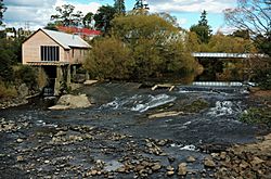
The Meander River weir.
|
|||||||||
| Population | 2,848 (2016 census) | ||||||||
| Postcode(s) | 7304 | ||||||||
| Elevation | 237 m (778 ft) | ||||||||
| Location |
|
||||||||
| LGA(s) | Meander Valley Council | ||||||||
| State electorate(s) | Lyons | ||||||||
| Federal Division(s) | Lyons | ||||||||
|
|||||||||
Deloraine is a lovely town located on the Meander River in the central north of Tasmania, Australia. It's about 50 kilometers west of Launceston and 52 kilometers south of Devonport. You can find it along the Bass Highway. Deloraine is part of the Meander Valley Council. In 2016, about 2,848 people lived there. Like many towns in Tasmania, Deloraine has a cool, wet climate.
Contents
History of Deloraine
The area around Deloraine was first explored in 1821 by Captain Roland. He was looking for good land for farming. Soon, new settlers were given land here. Today, Deloraine is a big farming area with many different types of farms.
The town's name, Deloraine, comes from a character in a famous poem. The poem is called The Lay of the Last Minstrel and was written by Sir Walter Scott. The Deloraine Post Office opened a long time ago, on October 29, 1836.
Deloraine has won some special awards too! It won the State Tidy Towns award in 1992, 1993, and 1995. It also won the Australian Community of the Year award in 1997.
Deloraine's Climate
Deloraine has a temperate climate, which means it's usually mild. It also gets a good amount of rain throughout the year. Here's a look at the weather details:
| Climate data for Deloraine | |||||||||||||
|---|---|---|---|---|---|---|---|---|---|---|---|---|---|
| Month | Jan | Feb | Mar | Apr | May | Jun | Jul | Aug | Sep | Oct | Nov | Dec | Year |
| Mean daily maximum °C (°F) | 22.4 (72.3) |
24.2 (75.6) |
19.6 (67.3) |
17.0 (62.6) |
13.8 (56.8) |
12.1 (53.8) |
12.0 (53.6) |
13.1 (55.6) |
13.9 (57.0) |
15.3 (59.5) |
18.5 (65.3) |
20.0 (68.0) |
15.7 (60.3) |
| Daily mean °C (°F) | 15.7 (60.3) |
15.8 (60.4) |
13.7 (56.7) |
10.7 (51.3) |
8.2 (46.8) |
7.0 (44.6) |
6.9 (44.4) |
7.3 (45.1) |
8.9 (48.0) |
9.8 (49.6) |
12.2 (54.0) |
14.3 (57.7) |
10.9 (51.6) |
| Mean daily minimum °C (°F) | 9 (48) |
9.1 (48.4) |
7.8 (46.0) |
4.3 (39.7) |
2.5 (36.5) |
1.9 (35.4) |
1.8 (35.2) |
1.5 (34.7) |
3.8 (38.8) |
4.2 (39.6) |
5.8 (42.4) |
8.6 (47.5) |
5.0 (41.0) |
| Average rainfall mm (inches) | 51 (2.0) |
50 (2.0) |
51 (2.0) |
77 (3.0) |
88 (3.5) |
102 (4.0) |
121 (4.8) |
118 (4.6) |
96 (3.8) |
82 (3.2) |
64 (2.5) |
63 (2.5) |
832 (32.8) |
| Mean monthly sunshine hours | 294 | 250 | 227 | 200 | 148 | 132 | 137 | 149 | 190 | 244 | 247 | 267 | 2,485 |
| Source 1: Meander Valley Climate Data | |||||||||||||
| Source 2: World Weather and Climate | |||||||||||||
Sister Cities
A sister city is a special partnership between two towns or cities in different countries. They often share cultural ideas and learn from each other. Deloraine has one sister city:
Deloraine's Economy
Deloraine is mainly a farming town, but it's also a popular spot for tourists. People visit to enjoy its culture and use it as a base to explore nearby places. These include Cradle Mountain, the Great Western Tiers, Mole Creek, and the Central Highlands.
Farms in the area grow crops like poppies, herbs, onions, and potatoes. These are common crops for Tasmania's climate. Deloraine is also home to 41° South, a special farm that raises salmon and grows ginseng. This is a type of aquaculture, which means farming in water.
The town has two sawmills that cut timber. There are also factories that make fertiliser, farm equipment, water tanks, and street signs. The nearby factory, Tasmanian Alkaloids, in Westbury, also provides jobs for some people from Deloraine.
For entertainment, Deloraine gets television and radio from the Launceston area. You can watch channels like ABC Television, SBS Television, and Tasmanian Digital Television. There are also radio stations like 91.7 ABC Northern Tasmania and commercial stations 89.3 LAFM and 90.1 Chilli FM.
A big event in Deloraine is the annual Tasmanian Craft Fair. It's a huge festival that attracts around 18,000 visitors every year! About 260 artists and craftspeople show off their work during the fair. Because of this fair and the many artists living there, Deloraine is known as a cultural center.
Infrastructure and Transport
Deloraine is located between the cities of Launceston and Devonport. This makes it an important place for moving goods and for tourists traveling between the two cities. Many local services, like supermarkets, shops, schools, and bus routes, are also used by people from nearby towns like Westbury, Exton, Mole Creek, and Meander.
The town has its own telephone exchange, which is run by Telstra. Deloraine was one of the first towns in Australia to get connected to the super-fast fibre optic National Broadband Network (NBN). By 2014, Deloraine, along with a few other towns, became one of the first all-fibre optic towns in Australia. This means they have very fast internet!
Transport Routes
The Emu Bay/Meander Valley Road goes right through the town.
One of the very first railway lines in Tasmania was built in 1871. It connected Launceston and Deloraine. This railway was used to ship farm products into the city. Today, the railway line that runs through Deloraine is mostly used for cargo trains. Tourist trains use it sometimes too.
You can reach Deloraine by the Bass Highway, which is part of Australia's National Highway. You can also use the older Meander Valley Road. The Bass Highway was built to bypass the town in the early 1990s, making travel smoother.
 | Chris Smalls |
 | Fred Hampton |
 | Ralph Abernathy |


