
Cradle Mountain facts for kids
Quick facts for kids Cradle Mountain |
|
|---|---|

Cradle Mountain as seen from the north, across Dove Lake
|
|
| Highest point | |
| Elevation | 1,545 m (5,069 ft) |
| Prominence | 355 m (1,165 ft) |
| Isolation | 4.95 km (3.08 mi) |
| Listing | 6th-highest mountain in Tasmania |
| Geography | |

Cradle Mountain
Location in Tasmania
|
|
| Location | Central Highlands, Tasmania, Australia |
| Parent range | Cradle Cirque - Bluff Cirque |
| Type of rock | dolerite |
| Climbing | |
| Normal route | Walk / hike via the Overland Track |
Cradle Mountain is a famous mountain and a beautiful area in the Central Highlands of Tasmania, Australia. It stands tall at 1,545 meters (about 5,069 feet) above sea level, making it the sixth-highest mountain in Tasmania. This amazing mountain is located inside the Cradle Mountain-Lake St Clair National Park, which is a protected area.
The area around the mountain is also called Cradle Mountain. It's a quiet, rural place managed by several local councils in Tasmania. About 69 people lived here in 2016. The main road, Route C132 (Cradle Mountain Road / Dove Lake Road), leads visitors right to the beautiful Dove Lake.
Contents
Mountain History
Cradle Mountain has a long history. The land originally belonged to the Big River and Northern Tasmanian Aboriginal people. They lived here for thousands of years before Europeans arrived.
Early European Exploration
Europeans first explored and climbed Cradle Mountain in the late 1800s. Joseph Fossey and Henry Hellyer were among the first to survey the area for a company called the Van Diemen's Land Company.
For many years, people worked as trappers in the area, catching animals for their fur. They built small huts and even used controlled fires to help new plants grow, which attracted more game animals. Later, hunting became illegal in the park.
Large forests of King Billy pines were discovered, and logging took place for some time. Even after the national park was created, logging continued on nearby private land, but it eventually stopped due to public protests. Farmers also used to graze their cattle and sheep in Cradle Valley.
Protecting the Land
In the early 1900s, Gustav and Kate Weindorfer explored Cradle Mountain. They were so amazed by its beauty that Gustav famously said, "This must be a national park for the people for all time."
They started a campaign to protect the area from Cradle Mountain to Lake St Clair. They even built a popular chalet for visitors. Because of their efforts, the area was first made a scenic reserve, then a wildlife reserve, and finally, a national park. Some former trappers became guides, helping people explore the wilderness.
In 1969, a fur trapper named Bert Nichols created the famous Overland Track. This walking trail starts at Cradle Mountain and goes south to Lake St Clair. By 1970, it was a well-known path used by many hikers.
Exploring the Mountain
The area around Cradle Mountain is perfect for outdoor adventures. There are many short walks you can do in a single day. It's also the starting point for the famous Overland Track, a challenging 80.8-kilometer (about 50-mile) hike that ends at Lake St Clair, Australia's deepest lake.
Many people climb Cradle Mountain almost all year round. It's a tough hike from the Dove Lake car park and can take several hours. The upper part of the mountain involves climbing over large rocks. The weather can change very quickly, so hikers need to be prepared. In winter, climbing can be dangerous because of ice and snow. From the top, you get amazing views of Dove Lake, Barn Bluff, and Mount Ossa.
Weather at Cradle Mountain
Cradle Mountain has a cool, wet climate. Summers are cool, and winters are cold with lots of snow. It rains a lot throughout the year. The weather station, located at 903 meters (about 2,963 feet) above sea level, records an average of 47.9 snowy days each year.
| Climate data for Cradle Valley (903 m AMSL) | |||||||||||||
|---|---|---|---|---|---|---|---|---|---|---|---|---|---|
| Month | Jan | Feb | Mar | Apr | May | Jun | Jul | Aug | Sep | Oct | Nov | Dec | Year |
| Record high °C (°F) | 30.0 (86.0) |
30.5 (86.9) |
25.1 (77.2) |
20.0 (68.0) |
17.8 (64.0) |
11.1 (52.0) |
11.5 (52.7) |
12.7 (54.9) |
17.9 (64.2) |
19.9 (67.8) |
22.0 (71.6) |
27.0 (80.6) |
30.5 (86.9) |
| Mean daily maximum °C (°F) | 16.6 (61.9) |
17.0 (62.6) |
14.4 (57.9) |
10.8 (51.4) |
7.9 (46.2) |
5.1 (41.2) |
4.6 (40.3) |
4.9 (40.8) |
7.5 (45.5) |
10.5 (50.9) |
12.8 (55.0) |
15.2 (59.4) |
10.6 (51.1) |
| Mean daily minimum °C (°F) | 5.2 (41.4) |
5.9 (42.6) |
4.7 (40.5) |
3.1 (37.6) |
1.5 (34.7) |
−0.2 (31.6) |
−0.2 (31.6) |
−0.5 (31.1) |
0.3 (32.5) |
1.5 (34.7) |
2.5 (36.5) |
4.1 (39.4) |
2.3 (36.2) |
| Record low °C (°F) | −1.0 (30.2) |
−1.9 (28.6) |
−2.5 (27.5) |
−4.0 (24.8) |
−8.3 (17.1) |
−8.3 (17.1) |
−7.8 (18.0) |
−8.5 (16.7) |
−8.0 (17.6) |
−5.0 (23.0) |
−3.5 (25.7) |
−1.3 (29.7) |
−8.5 (16.7) |
| Average precipitation mm (inches) | 148.8 (5.86) |
121.9 (4.80) |
148.1 (5.83) |
204.1 (8.04) |
276.4 (10.88) |
272.3 (10.72) |
315.7 (12.43) |
301.7 (11.88) |
269.4 (10.61) |
252.4 (9.94) |
205.1 (8.07) |
181.7 (7.15) |
2,815.8 (110.86) |
| Average precipitation days (≥ 0.2 mm) | 16.9 | 14.0 | 17.9 | 19.1 | 21.4 | 22.2 | 23.3 | 23.8 | 21.7 | 21.4 | 18.4 | 18.3 | 238.4 |
| Average relative humidity (%) | 74 | 77 | 84 | 89 | 90 | 92 | 93 | 90 | 85 | 80 | 77 | 74 | 84 |
| Source: Australian Bureau of Meteorology | |||||||||||||
Mountain Features
Cradle Mountain rises above several beautiful lakes formed by glaciers, including Dove Lake, Lake Wilks, and Crater Lake.
The mountain actually has four peaks that have names:
- Cradle Mountain (1,545 meters)
- Smithies Peak (1,527 meters)
- Weindorfers Tower (1,459 meters)
- Little Horn (1,355 meters)
The mountain got its name because its shape looks like a "cradle" used for gold mining.
Plants and Animals
The Cradle Mountain area is home to many different plants and animals.
Plants
You'll find a mix of alpine and sub-alpine plants here. One special plant is the deciduous beech, which loses its leaves in autumn, unlike most Australian native plants that stay green all year. Near the mountain's top, you'll see alpine coral fern and button grass.
At lower elevations, there are Tasmanian snow gums, Tasmanian eyebright, and colorful scoparia heath. In the valleys, you can explore dense temperate rainforests with myrtle beech, pandani, sassafras, King Billy pine, and celery top pine. These forests are often covered in thick moss.
Animals
You'll likely spot wombats wandering around. Other animals you might see include pademelons, Tasmanian devils, and echidnas.
Many birds live here too, such as green rosellas, black currawongs, pink robins, and Tasmanian scrubwrens. Look up, and you might see peregrine falcons and wedge-tailed eagles nesting on the cliffs. Be aware that Tiger snakes, which are venomous, also live in the area.
Fungi
Fungi are a very important part of the park's ecosystem, even though they are often overlooked. They help break down dead plants and leaves, returning important nutrients to the soil. Many plants also rely on fungi to help them grow.
One interesting fungus you might see is the strawberry bracket fungus (Tyromyces pulcherrimus). It grows on myrtle beech trees and snow gums. Scientists and nature lovers are working to record and map all the different types of fungi found in places like Cradle Mountain.

Gallery
-
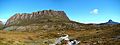
Panorama from the west, showing Cradle Mountain and, in the distance, Barn Bluff
-
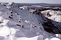
The rocky summit ridge of Cradle Mountain
-
Another view of the summit ridge of Cradle Mountain
-
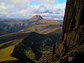
Cradle Mountain seen from the nearby Barn Bluff
-
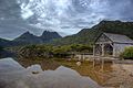
A beautiful view over Dove Lake; the boat shed was built in the 1940s
-
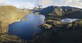
An aerial panorama of Cradle Mountain


See also
 In Spanish: Montaña Cradle para niños
