
Mount Ossa (Tasmania) facts for kids
Quick facts for kids Mount Ossa |
|
|---|---|

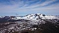
Mount Ossa pictured in 2009
|
|
| Highest point | |
| Elevation | 1,617 m (5,305 ft) |
| Prominence | 1,617 m (5,305 ft) |
| Isolation | 524 km (326 mi) |
| Listing | Ultra State high point |
| Geography | |

Mount Ossa
Location in Tasmania
|
|
| Location | Central Highlands of Tasmania, Australia |
| Parent range | Pelion Range |
| Geology | |
| Age of rock | Jurassic |
| Mountain type | Dolerite |
| Climbing | |
| Easiest route | 3+1⁄2 hour return from Pelion Gap via the Overland Track |
Mount Ossa is the tallest mountain in Tasmania, Australia. It stands 1,617 metres (5,305 ft) above sea level. This impressive peak is part of the Pelion Range and is located inside the beautiful Cradle Mountain-Lake St Clair National Park. You can find it in the Central Highlands area of Tasmania.
European explorers first surveyed Mount Ossa in the 1860s. However, it was not until 1954 that it was officially confirmed as Tasmania's highest point. Like many mountains in this area, Mount Ossa has a top made of Jurassic dolerite rock.
Contents
Exploring Mount Ossa's Past
The area around Mount Ossa was once home to the Big River and Northern Tasmanian Aboriginal people. They lived here for thousands of years. Archeologists have found many old tools and campsites around Pelion and Lake St Clair (Tasmania). These finds show that Aboriginal people used different kinds of stone for their tools.
How Mount Ossa Got Its Name
Charles Gould, a geologist, first surveyed Mount Ossa in the 1860s. He named it after Mount Ossa in Greece. This was part of a trend to give Greek names to places in Tasmania, started by an early surveyor named George Frankland.
For a long time, people thought Cradle Mountain was Tasmania's highest peak. The equipment used for surveying was not very exact back then. This made it hard to measure the mountains accurately. Mount Ossa was sometimes called Parsons Hood, Mount Dundas, or Mount Blackhouse. Finally, an aerial survey in 1954 confirmed that Mount Ossa was indeed the tallest mountain in Tasmania.
Early Activities and Development
In 1892, a company found Permian coal near Mount Ossa. They dug several tunnels to explore it. However, the coal was not very good quality, so the tunnels were not used much. There was also some copper mining in the areas nearby. Later, in the 1920s, people tried to find oil, but this attempt failed.
These mining and surveying activities helped to develop the area. The Stewards Track was built from the east. It was later extended and renamed the Innes Track, which is now called the Arm River Track. Old Pelion Hut was used as a base for mining operations. Today, it is a hut for hikers on the Overland Track and a starting point for those climbing Mount Ossa.
Trappers also worked in the area from the 1860s. They hunted animals for their fur until the fur trade ended in the 1950s. Even though hunting in the park became illegal after 1927, trappers had already built huts, some of which are still used today. They also used controlled burning to help new plants grow, which attracted more game animals.
Becoming a National Park
In the 1910s, Gustav and Kate Weindorfer started a campaign. They wanted the area from Cradle Mountain to Lake St Clair, including Mount Ossa, to become a national park. Their efforts paid off! The area was first made a scenic reserve in 1922. Then, it became a wildlife reserve in 1927. Finally, in 1947, it was officially named a national park.
After the park was created, some former trappers became guides for bushwalkers. They also built huts for visitors. Famous guides included Paddy Hartnett, Gustav Weindorfer, and Bob Quaile. Since then, Mount Ossa has become a very popular place for bushwalking. Many people enjoy hiking to its summit. In 1991, about 30% of people walking the Overland Track also took a side trip to climb Mount Ossa.
Climbing Mount Ossa
You can climb Mount Ossa using a well-used path. This path starts from Pelion Gap and leads to the summit. Hikers can reach Pelion Gap either as a side trip from the Overland Track or by using the Arm River Track.
Be aware that conditions can be very harsh in winter. There can be strong winds and freezing temperatures. To reach the very top, you will need to do a short scramble over rocks.
Gallery
-
Mount Ossa, as viewed from the summit of Mt Pelion East
-
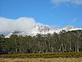
Mount Ossa From Pelion Plains


See also
 In Spanish: Montaña Ossa para niños
