
Great Western Tiers facts for kids
Quick facts for kids Great Western Tiers |
|
|---|---|

Drys Bluff, part of the Great Western Tiers
|
|
| Highest point | |
| Peak | Ironstone Mountain |
| Elevation | 1,444 m (4,738 ft) AHD |
| Dimensions | |
| Length | 100 km (62 mi) NE/SW |
| Geography | |

Location in Tasmania
|
|
| Country | Australia |
| Range coordinates | 41°55′48″S 147°10′12″E / 41.93000°S 147.17000°E |
| Geology | |
| Age of rock | Jurassic |
| Type of rock | Dolerite |
The Great Western Tiers are a group of mountain cliffs in Tasmania, Australia. They form the northern edge of the Central Highlands plateau. A plateau is a large area of flat land that is much higher than the land around it.
These impressive cliffs stretch for over 100 kilometres (62 mi) (about 62 miles). They go from the 1,420-metre (4,660 ft) (4,659 ft) Western Bluff near Mole Creek to the 1,210-metre (3,970 ft) (3,970 ft) Millers Bluff, which is about 25 kilometres (16 mi) (15.5 miles) west of Campbell Town. The Great Western Tiers are part of the Tasmanian Wilderness World Heritage Site. This means they are a very special natural area protected for everyone to enjoy. In the late 1800s, people called them the Great Western Range.
Contents
Geological Features of the Tiers
The Central Highlands, also known as the Tasmanian central plateau, was pushed upwards a very long time ago. This happened during the Eocene epoch, which was about 34 to 56 million years ago. This movement created the steep cliffs of the Tiers.
The northern edge of the plateau is between 760 metres (2,490 ft) (2,493 ft) and 1,500 metres (4,900 ft) (4,921 ft) high. This boundary was formed by large cracks in the Earth's crust, called faults. These faults caused the land to move and create the high cliffs.
Dividing the Landscape
The Great Western Tiers act like a natural wall. They separate the high, rocky, and mostly empty central plateau from the rich, fertile farmlands of the Meander Valley and the northern midlands.
The edges of the Tiers have very clear cliffs and tall columns of rock. This rock is called dolerite, and it formed during the Jurassic period, about 145 to 200 million years ago. The highest point in the Tiers is Ironstone Mountain, which is 1,444-metre (4,738 ft) (4,738 ft) tall. Unlike most of the other cliffs, you cannot see Ironstone Mountain from the Meander Valley because it is further south on the plateau.
How the Tiers Changed Over Time
The face of the Tiers has slowly worn away and moved back over time. It has moved back about 4 miles (6.4 km) (6.4 km) since it was formed. This is why Quamby Bluff stands alone, separate from the main line of cliffs.
The central plateau has also been shaped by glaciers. Glaciers are huge sheets of ice that slowly move and carve out the land. The valleys below the Tiers are filled with scree slopes. These are piles of broken rocks and boulders that have fallen from the cliffs. About 25% of this material is soil that formed as the boulders broke down.
Notable Peaks and Bluffs
The Great Western Tiers are home to many important peaks and bluffs. Some of these include:
- Brady's Lookout, at 1,371 metres (4,498 ft) (4,498 ft). This peak is named after the famous bushranger Matthew Brady.
- Billop Bluff
- Dry's Bluff, at 1,298 metres (4,259 ft) (4,259 ft). This is where the Liffey River begins.
- Ironstone Mountain, the highest peak, at 1,444 metres (4,738 ft) (4,738 ft).
- Millers Bluff, at 1,210 metres (3,970 ft) (3,970 ft).
- Mother Cummings Peak, at 1,255 metres (4,117 ft) (4,117 ft).
- Mount Blackwood
- Mount Parmeener
- Neals Bluff
- Panorama Hill
- Projection Bluff
- Quamby Bluff, at 1,227 metres (4,026 ft) (4,026 ft).
- Western Bluff, at 1,420 metres (4,660 ft) (4,659 ft).
Images for kids
-
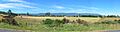
Panorama from Chudleigh towards the Great Western Tiers
