Quamby Bluff facts for kids
Quick facts for kids Quamby Bluff |
|
|---|---|

Quamby Bluff
|
|
| Highest point | |
| Elevation | 1,227 m (4,026 ft) AHD |
| Prominence | 494 m (1,621 ft) |
| Geography | |
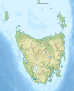
| Location | Tasmania, Australia |
| Parent range | Great Western Tiers |
| Topo map | TASMAP 1:25,000 Quamby Bluff |
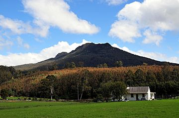
Quamby Bluff is a cool mountain in Northern Tasmania, Australia. It's like a lone peak that stands out from the main Great Western Tiers mountain range. This bluff is a popular spot for hikers and offers amazing views of the surrounding area.
Contents
Discovering Quamby Bluff: Location and History
Quamby Bluff is located about 19 kilometers (12 miles) from the town of Deloraine. It sits just north of the main cliffs of the Great Western Tiers.
What Does "Quamby" Mean?
The name "Quamby" has a few possible meanings. Some think it comes from a place in England called Quarmby. Others believe it's from an old Viking word meaning "mill farm." However, the most likely origin is from local Tasmanian languages. In these languages, "Quamby" might mean "a place of rest" or "a good camping spot."
An old story from 1859 suggests another meaning. It says that a British colonist once aimed his gun at an Indigenous Tasmanian. The Tasmanian person then cried out "Quamby!", which was thought to mean "Spare me!" or "Mercy!".
How Quamby Bluff Was Formed: Geology and Landscape
Quamby Bluff has a fascinating geological story. The entire Tasmanian central plateau, including the Great Western Tiers, was pushed upwards from the lower Meander Valley a very long time ago. This probably happened during the Eocene epoch.
The Bluff's Unique Shape
Over millions of years, the face of the Great Western Tiers has slowly worn away. This erosion has moved the cliffs back by about 4 miles (6.4 kilometers). Because of this, Quamby Bluff now stands alone as a separate mountain. It looks similar to the rest of the range, with steep cliffs and slopes made of broken rocks and soil.
From the top of Quamby Bluff, you can see a huge part of Northern Tasmania. On clear days, you might even spot Mount Strzelecki on Flinders Island, which is about 200 kilometers (124 miles) away! The flat top of the mountain is 1,227 meters (4,026 feet) above sea level.
Rocks and Layers
The base of the mountain is made of sandstone and mudstone from the Triassic period. These rocks lie in almost flat layers. Later, during the Jurassic period, Dolerite rocks pushed through this base. Erosion has shaped these dolerite rocks into the steep cliffs and rocky slopes you see at the top of the mountain.
Quamby Bluff also has some of the oldest rocks found in Tasmania. These Proterozoic era rocks are metamorphosed sediments. This means they are old sediments that have changed due to heat and pressure. They contain layers of graphite, mica, and schists.
Weather on the Mountain
The area around Quamby Bluff gets about 1,100 millimeters (43 inches) of rain each year, mostly in winter. The higher you go up the mountain, the more rain it gets. At the summit, it can receive up to 2,300 millimeters (91 inches) of rain. Snow can fall above 1,000 meters (3,280 feet) at any time of year, and the top of the bluff often gets regular snowfall. Because it's so exposed, the summit can have very strong winds and harsh weather.
Life Around Quamby Bluff: People, Plants, and Animals
The first people to live in this area were the Pallittorre Clan, part of the Northern Nation of Aboriginal Tasmanians. They called Quamby Bluff "lartitickitheker." There are caves nearby with signs of Aboriginal people living there, possibly for thousands of years.
Traditional Land Management
The Pallittorre people were skilled land managers. They kept grassy plains clear by carefully burning the land. They also used this method to control undergrowth in the forests. This made hunting and gathering food easier.
European settlers later arrived and began logging in the area. You can still see old tree stumps and trails from this time. There are even remains of a sawmill from the 1940s on the eastern slopes.
Amazing Plants and Trees
Because Quamby Bluff stands alone, it has a wider variety of habitats and plants than other parts of the Great Western Tiers. The plants and trees here are common to the region, but unlike other areas, the summit of Quamby Bluff doesn't show signs of damage from fires or grazing.
The mountain has different types of plant life, including eucalypt forests, rainforests, and plants that grow in subalpine areas (high up, near the tree line).
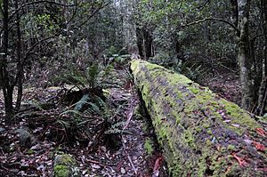
- Rainforest Patches: On the southern side, you'll find patches of callidendrous rainforest. These are full of myrtle (Nothofagus cunninghamii) and sassafras (Atherosperma moschatum) trees. You'll also see mother shield ferns (Polystichum proliferum) and tree ferns in the valleys.
- King Billy Pines: Some rare king billy pines (Athrotaxis selaginoides) grow on the southern slopes. Their presence suggests that these areas haven't had many bushfires for a long time.
- Mixed Forests: Other parts have mixed forests with stringybark trees (like Eucalyptus delegatensis), myrtle, sassafras, and dogwood (Pomaderris apetala). Below them, you might see silver wattle (Acacia dealbata).
- Dryer Forests: In drier areas, eucalypts dominate, such as Messmate Stringybark (eucalyptus obliqua). These areas often have an understorey of silver wattle, dogwood, and bracken. The patterns of plants here show that these areas have experienced repeated fires.
- Summit Shrubs: The very top of the mountain is windy and exposed. Here, you'll find low, wind-pruned shrubs like Narrow-Leaf Orites (Orites revolutus), Baeckea gunniana, Common Shaggy-pea (Oxylobium ellipticum), Leptospermum rupestre, Richea sprengelioides, Richea scoparia, and Kerosine Bush (Ozothamnus hookeri).
Animals of Quamby Bluff
While there hasn't been a full animal survey, some interesting creatures have been spotted. Feral goats have been recorded on the mountain. Birdwatchers might see Pink robins and green rosellas. In the shady, moist areas, you might find scrubtits and Bassian thrush.
Protecting Quamby Bluff: The Forest Reserve
Quamby Bluff is part of a special forest reserve. This reserve was created on December 15, 1982, to protect the area. It mostly covers the land above 540 meters (1,770 feet) in elevation and spans 945 hectares (2,335 acres). Most of this land is still in its natural state.
Since 1990, no mining or prospecting is allowed in the Quamby Bluff forest reserve. In 2013, this reserve became part of the Tasmanian Wilderness World Heritage Area, which means it's recognized as a place of global importance.
Hiking and Exploring
Quamby Bluff is one of the easier peaks in the Tiers to climb. The walk to the summit is a popular day trip and can be done in an afternoon. The most popular trail is called the fairy glade track, which you can reach from Lake Highway.
There are no official car parks or facilities in the forest reserve. The trails are marked simply with small colored metal triangles, piles of rocks (cairns), and colored plastic tape. You are allowed to camp there, and dogs are welcome if they are on a leash. However, hunting is not allowed.
 | John T. Biggers |
 | Thomas Blackshear |
 | Mark Bradford |
 | Beverly Buchanan |


