
Ironstone Mountain facts for kids
Quick facts for kids Ironstone Mountain |
|
|---|---|

Visually dominant slightly lower part of the mountain
|
|
| Highest point | |
| Elevation | 1,444 m (4,738 ft) AHD |
| Prominence | 194 m (636 ft) |
| Geography | |

Ironstone Mountain
Location in Tasmania
|
|
| Location | Central Highlands, Tasmania, Australia |
| Parent range | Great Western Tiers |
| Topo map | Tasmap Lake Mackenzie (4438) 1:25000 |
| Geology | |
| Age of rock | Jurassic |
The Ironstone Mountain is a cool mountain found in the middle part of Tasmania, Australia. It's part of the Great Western Tiers, which is a long, steep edge of land. The mountain sits south of a small village called Mole Creek.
Ironstone Mountain stands tall at 1,444 meters (about 4,738 feet) above sea level. This makes it the highest peak in the Great Western Tiers. Near the mountain, you'll find a beautiful lake called Lake Ironstone. The very top of the mountain has a special marker called a trig point. However, the part of the mountain that looks most impressive is actually a bit lower, as you can see in the picture.
Where is Ironstone Mountain?
Ironstone Mountain is located in the Central Highlands area of Tasmania. You can find its exact spot using a special map reference: 563819 UTM Zone 55S. This is part of the Universal Transverse Mercator coordinate system, which helps people find precise locations on Earth. Detailed maps of the area are available from Tasmap, specifically the Lake Mackenzie (4438) 1:25000 map.
How to Get to Ironstone Mountain
There are two main ways to reach Ironstone Mountain by walking. Both routes are popular for hikers.
One way to get there is from the north. You would travel through Mole Creek, then Caveside, and finally along Westrope Road. This leads you to the Western Creek Track. This path follows the eastern side of a valley created by Western Creek.
Another way to access the mountain is from the east. This route starts from Deloraine, then Meander, and along Smoko Road. You'll then find the Mount Ironstone Track. This track begins about 2 kilometers (1.2 miles) south of Mother Cummings Peak, which is another well-known landmark in the region.
Images for kids
-
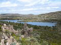
Lake Ironstone, a beautiful lake near the mountain.
-
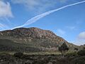
A jet trail seen over Ironstone Mountain.
-
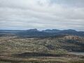
The stunning Walls of Jerusalem National Park as seen from Ironstone Mountain.


