Bass Strait facts for kids
Quick facts for kids Bass Strait |
|
|---|---|
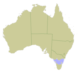
Map of Australia with Bass Strait marked in light blue
|
|
| Location | Indian Ocean–Pacific Ocean |
| Coordinates | 40°S 146°E / 40°S 146°E |
| Type | Strait |
| Basin countries | Australia |
| Max. length | 500 kilometres (310 mi) |
| Max. width | 350 kilometres (220 mi) |
| Average depth | 60 metres (200 ft) |
| Max. depth | 155 m (509 ft) |
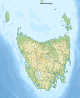
Bass Strait (/bæs/) is a body of water that separates the island state of Tasmania from the main part of Australia. It lies between Tasmania and the coast of Victoria. This strait is like a watery highway. It offers the most direct path for ships between the Great Australian Bight and the Tasman Sea. It's also the only sea route into the important Port Phillip Bay.
Bass Strait was formed about 8,000 years ago. This happened when sea levels rose after the last glacial period. The strait was named after George Bass, an English explorer and doctor. He was recognized by early European settlers.
Contents
Where is Bass Strait?
Bass Strait connects two big oceans. It links the Indian Ocean and the Pacific Ocean. Some people think it's part of the Pacific Ocean. Others say it's part of the Tasman Sea. The Australian Hydrographic Service says it's part of the Tasman Sea.
How was Bass Strait discovered?
First people to cross
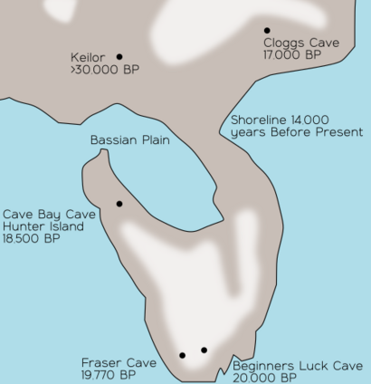
Aboriginal Tasmanians arrived in Tasmania around 40,000 years ago. They crossed a wide land bridge called the Bassian Plain. This bridge connected what is now Victoria and Tasmania. When the ice age ended, sea levels rose. The Bassian Plain was flooded about 8,000 years ago. This created Bass Strait and separated Tasmania from the mainland. Aboriginal people lived on Flinders Island for a long time.
European explorers
The strait might have been seen by Captain Abel Tasman in 1642. He was charting Tasmania's coast. His ships were hit by strong winds from the strait. He then turned away to the east.
Captain James Cook also came close in 1770. He sailed towards the strait but turned back. He wasn't sure if Tasmania was an island or connected to the mainland.
The strait was officially discovered by George Bass and Matthew Flinders. They sailed through it in 1798–99. They were exploring around Tasmania. Governor John Hunter named the water "Bass's Straits" in 1800. It later became known as Bass Strait.
News of the strait's discovery reached Europe. This led the French government to send an exploration trip. Because of this, Governor King sent ships to Tasmania. They set up a settlement in Hobart.
What is the weather like?
Bass Strait is known for its rough and wild waters. Strong currents flow between the Indian Ocean and the Pacific Ocean. This creates powerful storm waves. Many ships have been lost here over the years. Modern ships and navigation tools have made it much safer.
Some ships have disappeared without a trace. People have made up stories about pirates and strange events. But most disappearances are due to bad weather. They are also caused by hidden rocks and reefs.
Despite the rough conditions, the strait was important. It offered a safer route for ships from Europe to Sydney. It also saved ships about 1,300 km (700 nmi) on their journey.
Geography of Bass Strait
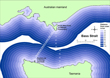
Bass Strait is about 250 km (160 mi) wide and 500 km (310 mi) long. Its average depth is about 60 m (200 ft). The widest part is about 350 km (220 mi) across. This is between Cape Portland in Tasmania and Point Hicks on the mainland.
In the middle of the strait is a shallow area called the Bass Basin. It's about 120 km (70 mi) wide and 400 km (250 mi) long. The deepest point is 155 m (510 ft). There are also underwater plateaus. These are called the Bassian Rise and King Island Rise. They are made of old granite rock.
During the Ice Age, sea levels were much lower. The central part of Bass Strait was a large, shallow lake. As sea levels rose, the lake was flooded. This formed Bass Strait about 8,000 years ago. That's when Tasmania became an island.
Because it's not very deep, the strait can be very rough. Many lighthouses were built to help ships. These include lighthouses on Deal Island, Cape Otway, and King Island.
Islands in Bass Strait
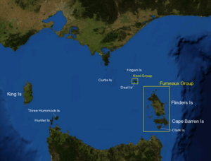
There are over 50 islands in Bass Strait. Here are some of the main ones:
- Western section:
* King Island * Three Hummock Island * Hunter Island * Robbins Island
- South eastern section:
* Furneaux Group ** Flinders Island (where some Aboriginal Tasmanians were moved) ** Cape Barren Island ** Clarke Island ** Sister Islands Group
- North eastern section:
* Kent Group ** Deal Island * Hogan Island * Curtis Island
Protected areas
Many smaller islands in Bass Strait are protected. For example, the Kent Group National Park protects the Kent Group islands. It also protects the surrounding state waters.
Victoria has several marine national parks along its coast in Bass Strait:
- Bunurong
- Ninety Mile Beach
- Point Addis
- Port Phillip Heads
- Twelve Apostles
- Wilsons Promontory
Natural resources
Bass Strait is rich in natural resources. There are many oil and gas fields in the eastern part. These fields were found in the 1960s. They are located off the coast of Gippsland. Some large fields include Halibut, Cobia, and Kingfish. Large gas fields include Whiptail, Barracouta, and Snapper.
Oil and gas are sent through pipelines to processing plants. These plants are in places like Longford and Altona.
In 2017, the Victorian government started a study for Australia's first offshore wind farm. This project could have 250 wind turbines. It could provide a lot of electricity for Victoria.
Infrastructure
Transport
The fastest way to cross Bass Strait is by air. Major airports in Tasmania are Hobart Airport and Launceston Airport. Airlines like Jetstar and Virgin Australia fly there.
Ferries
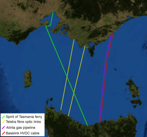
Two passenger ferries, called Spirit of Tasmania, travel across the strait. They are based in Devonport, Tasmania. The ships travel daily between Devonport and Geelong. They offer overnight trips and extra daytime trips in summer.
Energy
The Basslink electrical cable has been working since 2006. It can carry up to 630 megawatts of electricity. This connects Tasmania to the mainland power grid.
There is also a gas pipeline owned by Alinta. It delivers natural gas to customers in Tasmania.
Communications
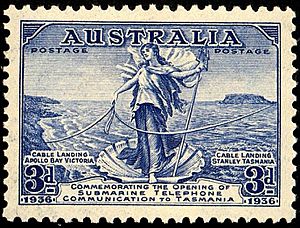
The first underwater communication cable was laid in 1859. It connected Victoria to Tasmania. However, it stopped working completely by 1861.
Today, Tasmania is connected to the mainland by two Telstra fibre optic cables. There is also dark fibre capacity on the Basslink cable.
Popular culture
The Bass Strait has been part of some interesting stories. In 1978, a famous UFO incident happened here. A pilot named Frederick Valentich reported a strange object near his plane. He then vanished, and neither he nor his plane were ever found.
Many planes, ships, and people have been lost in the strait. Some theories suggest mysterious reasons. But most disappearances are likely due to extreme weather.
On the Australian TV show Neighbours, a dramatic storyline involved a plane crash. A plane crashed into Bass Strait, putting many characters in danger.
Non-motorised crossings
Many people cross Bass Strait using non-motorised ways. This includes sailing, windsurfing, and even swimming. The annual Melbourne to Hobart Yacht Race crosses the strait.
Sailing
The first windsurfer crossing was in 1982. In 1998, Nick Moloney was the first to windsurf alone across the strait. He did it in 22 hours.
In 2005, Olympic sailor Michael Blackburn set a record. He crossed the strait in just over 13 hours in a Laser sailing dinghy.
In 2009, two young sailors crossed in a B14 (dinghy). They did it to raise money for the endangered Tasmanian Devil. They completed the trip in under 15 hours.
Kitesurfers have also crossed. Natalie Clark was the first woman to do it in 2010.
Rowing / Paddling
In 1971, David Bowen rowed across Bass Strait alone in a dory.
The first paddleboard crossing was in 2014. It was done by Jack Bark, Brad Gaul, and Zeb Walsh.
Rod Harris, Ian, and Peter Richards were the first to cross by sea kayak in 1971. Many kayakers have crossed since then. Andrew McAuley was the first to cross non-stop in a sea kayak in 2003.
Swimming
Tammy van Wisse swam part of the strait in 1996. She swam from King Island to Apollo Bay in Victoria. This was a distance of about 100 km (60 mi). She completed it in 17 hours and 46 minutes.
See also
 In Spanish: Estrecho de Bass para niños
 | Lonnie Johnson |
 | Granville Woods |
 | Lewis Howard Latimer |
 | James West |


