Abel Tasman facts for kids
Quick facts for kids
Abel Tasman
|
|
|---|---|
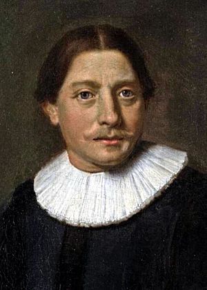
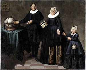
Detail from portrait by Jacob Gerritsz. Cuyp, c. 1637
|
|
| Born | 1603 Lutjegast, Dutch Republic
|
| Died | 10 October 1659 (aged 55–56) |
| Nationality | Dutch |
| Occupation | Navigator, explorer sea captain |
| Spouse(s) |
|
| Children | Claesjen Tasman (daughter) |
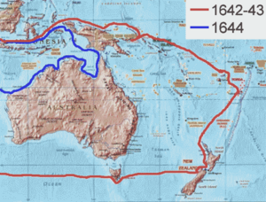
Abel Janszoon Tasman (Dutch: [ˈɑbəl ˈjɑnsoːn ˈtɑsmɑn]; 1603–10 October 1659) was a famous Dutch navigator, explorer, and merchant. He is best known for his amazing sea journeys in 1642 and 1644. He worked for the Dutch East India Company (VOC). Tasman was the first known European explorer to reach New Zealand, the islands of Fiji, and Van Diemen's Land (which is now called Tasmania).
Contents
Who Was Abel Tasman?
Abel Tasman was born around 1603 in Lutjegast, a small village in the northern part of the Netherlands. We know he was a seafarer living in Amsterdam when he got engaged at age 28. This was in 1631, and he was marrying 21-year-old Jannetje Tjaers.
Adventures in the Dutch East Indies
Tasman started working for the Dutch East India Company (VOC). In 1633, he sailed from the Netherlands to Batavia (which is now Jakarta, Indonesia). He took a southern route called the Brouwer Route.
While in Batavia, Tasman joined a trip to Seram Island in Indonesia. The local people there had sold spices to other European countries, which the Dutch didn't like. During a risky landing, several of Tasman's friends were killed by the islanders, but he managed to escape.
By 1637, Tasman was back in Amsterdam. The next year, he signed up to work for the VOC for another ten years. He took his wife with him to Batavia.
In 1639, he was second-in-command of an expedition exploring the north Pacific. They sailed to places like Taiwan and Deshima in Japan.
Tasman's First Big Voyage (1642)
In August 1642, the leaders of the Dutch East India Company in Batavia sent Tasman on a new journey. They wanted him to explore unknown areas. These areas were east of Africa, west of South America, and south of the Solomon Islands.
One main goal was to find "Provinces of Beach." This was a made-up land that Europeans believed had lots of gold. It appeared on maps because of a mistake in some books by Marco Polo.
Tasman used two small ships for this trip: the Heemskerck and the Zeehaen.
Stopping in Mauritius
Tasman left Batavia on August 14, 1642. He arrived at Mauritius on September 5, 1642. They stopped there because the island had plenty of fresh water, food, and wood to fix the ships. The governor of Mauritius, Adriaan van der Stel, helped them.
Mauritius was a good turning point because of the strong winds there. After staying for four weeks, both ships left on October 8. They used the strong winds of the Roaring Forties to sail east quickly. On November 7, because of snow and hail, they decided to change course. They aimed for a more north-easterly direction, hoping to reach the Solomon Islands.
Discovering Tasmania
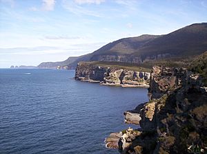
On November 24, 1642, Tasman saw land. It was the west coast of Tasmania, north of Macquarie Harbour. He named this new land Van Diemen's Land, after Anthony van Diemen, who was the Governor-General of the Dutch East Indies.
Tasman sailed south around Tasmania and then turned north-east. He tried to enter Adventure Bay, but a storm pushed his ships back out to sea. He named this area Storm Bay. Two days later, on December 1, Tasman anchored near Cape Frederick Hendrick. On December 2, some of his crew landed and gathered edible plants. Tasman named the bay Frederick Hendrik Bay.
The next day, December 3, they tried to land in North Bay. The sea was too rough, so a ship's carpenter swam ashore. He planted the Dutch flag, and Tasman officially claimed the land.
For two more days, he followed the east coast north. When the land turned north-west, he tried to follow it. But his ships were hit by the strong Roaring Forties winds. Tasman's mission was to find a large southern continent, not more islands. So, he quickly turned east and continued his search for the continent.
Reaching New Zealand
Tasman had planned to sail north, but the wind was not good. So, he steered east. The journey was very rough. Tasman wrote in his diary that his compass was the only thing that kept him alive.
On December 13, 1642, they saw land on the north-west coast of the South Island of New Zealand. They were the first Europeans to see New Zealand! Tasman named it Staten Landt to honor the Dutch parliament. He thought this land might be connected to a landmass at the southern tip of South America. He believed he had found the western side of the imagined Terra Australis, a huge southern land.
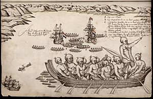
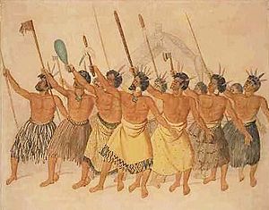
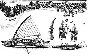
After sailing north and then east for five days, the ships anchored about 7 kilometres (4.3 mi) from the coast. This area is now called Golden Bay. A group of Māori came out in a waka (canoe). They attacked some sailors who were rowing between the two Dutch ships. Four sailors were sadly killed. As Tasman sailed out of the bay, he saw 22 waka near the shore. Eleven of them came towards his ships. The Zeehaen fired, hitting a man in the largest waka. Tasman named the area "Murderers' Bay."
The expedition then sailed north. They saw Cook Strait, but they thought it was just a bay and named it "Zeehaen's Bight." Two names Tasman gave to places in the far north of New Zealand are still used today: Cape Maria van Diemen and Three Kings Islands.
The Return Journey
On his way back to Batavia, Tasman found the Tongan islands on January 20, 1643. While passing the Fiji Islands, Tasman's ships almost crashed on dangerous reefs. He mapped the eastern tip of Vanua Levu and Cikobia-i-Lau before heading back to the open sea.
The expedition then turned north-west towards New Guinea. They arrived back in Batavia on June 15, 1643.
Tasman's Second Major Voyage (1644)
Tasman left Batavia again on January 30, 1644, for his second big voyage. He had three ships: the Limmen, Zeemeeuw, and a smaller boat called the Braek. He sailed along the south coast of New Guinea, trying to find a passage to the eastern side of New Holland (Australia).
However, he missed the Torres Strait between New Guinea and Australia. This was probably because of the many reefs and islands that hid the possible routes. He continued his journey by following the coast of the Gulf of Carpentaria westwards along the north Australian coast. He mapped the northern coast of Australia and made notes about the land and its people. He returned to Batavia in August 1644.
From the point of view of the Dutch East India Company, Tasman's explorations were a bit disappointing. He hadn't found a good area for trade or a useful new shipping route. Even though Tasman was welcomed back, the company was not happy that he hadn't fully explored the lands he found. They decided that a more "persistent explorer" should be chosen for future trips. For over a hundred years after Tasman, Europeans did not visit Tasmania and New Zealand. Mainland Australia was visited, but usually by accident.
Later Life and Legacy
On November 2, 1644, Abel Tasman became a member of the Council of Justice in Batavia. He traveled to Sumatra in 1646 and to Siam (now Thailand) in 1647. In 1648, he led an expedition to Manila to try and capture Spanish silver ships, but he was not successful. He returned to Batavia in January 1649.
In November 1649, he faced a legal issue and was found guilty of a serious charge from the previous year. He was suspended from his commander role, fined, and had to pay money to the family of a sailor. On January 5, 1651, he was officially given his rank back. He spent his remaining years in Batavia. He was quite wealthy and owned a lot of land in the town. He died in Batavia on October 10, 1659. He left behind his second wife and a daughter from his first wife. In his will, he left 25 guilders to the poor people of his home village, Lutjegast.
Even though Tasman's pilot, Frans Visscher, published a report about the discovery of the South land in 1642, Tasman's own detailed journal was not published until 1898. However, some of his maps were used by other explorers. Tasman's original journal from the 1642 voyage is kept in the Dutch National Archives.
Tasman's Lasting Impact
Tasman's ten-month journey in 1642–43 had big effects. By sailing around Australia (even if from a distance), Tasman showed that this continent was not connected to a larger, imagined Southern Continent. However, Tasman thought New Zealand was part of that Southern Continent. Many mapmakers in Europe believed this for the next century. They drew New Zealand as the west coast of a huge landmass called Terra Australis. This idea was finally proven wrong when Captain James Cook sailed around New Zealand in 1769.
Many places are named after Abel Tasman, including:
- The Australian island and state of Tasmania, which was renamed after him. It used to be called Van Diemen's Land.
- The Tasman Peninsula in Tasmania.
- The Tasman Bridge.
- The Tasman Highway.
- The Tasman Sea, which is between Australia and New Zealand.
- In New Zealand:
- The Tasman Glacier.
- Tasman Lake.
- The Tasman River.
- Mount Tasman.
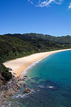
- The Abel Tasman National Park.
- Tasman Bay / Te Tai-o-Aorere.
- The Tasman District.
- Abel Tasman Monument.
Other things named after Tasman include:
- Tasman Pulp and Paper company in New Zealand.
- Abel Tasman Drive in Tākaka, New Zealand.
- The old passenger ferry Abel Tasman.
- The Able Tasmans – an indie band from New Zealand.
- Tasman, a computer program for web browsers.
- 6594 Tasman (1987 MM1), a small asteroid in space.
- Tasman Drive in San Jose, California, and its light rail station.
- Tasman Road in Claremont, South Africa.
- HMNZS Tasman, a training base for the Royal New Zealand Navy.
- HMAS Tasman, a new ship for the Royal Australian Navy.
Tasman's picture has been on four New Zealand postage stamps, a 1992 New Zealand coin, and Australian postage stamps in 1963, 1966, and 1985. In the Netherlands, many streets are named after him. In his birth village of Lutjegast, there is a museum about his life and travels.
The Tasman Map
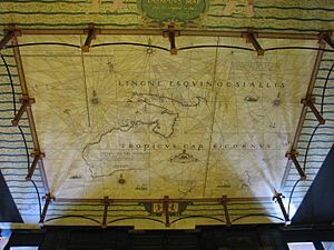
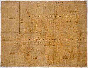
The State Library of New South Wales has a special map called the Tasman map. It is believed that Isaack Gilsemans drew it, or it was finished under the guidance of Franz Jacobszoon Visscher. This map is also known as the Bonaparte map because it once belonged to Prince Roland Bonaparte, who was a great-nephew of Napoleon. The map was finished sometime after 1644. It is based on the original charts drawn during Tasman's first and second voyages. Since no journals or logs from Tasman's second voyage have survived, the Bonaparte map is a very important historical item. It shows what was known about Tasman's journey to the northern coast of Australia.
The Tasman map shows how much the Dutch understood about the Australian continent at that time. It includes the western and southern coasts of Australia. These were accidentally found by Dutch sailors traveling to the VOC headquarters in Batavia. The map also shows the routes of Tasman's two voyages. For his second voyage, the map shows the Banda Islands, the southern coast of New Guinea, and much of the northern coast of Australia. However, the areas near the Torres Strait are shown as unexplored. This is interesting because Tasman had been ordered by the VOC to look for a channel between New Guinea and Australia.
There is some discussion about where the map came from. Many believe it was made in Batavia. However, some argue it was made in Amsterdam. The person who created the map is also debated. While it's often linked to Tasman, it's now thought to be a team effort. This likely included Franchoijs Visscher and Isaack Gilsemans, who were both on Tasman's voyages. Whether the map was made in 1644 is also debated. A VOC report from December 1644 suggested that no maps showing Tasman's voyages were complete at that time.
In 1943, a mosaic version of the map was placed in the floor of the Mitchell Library in Sydney. It was made of colored brass and marble. The librarian, William Ifould, asked for this work to be done. It was completed by the Melocco Brothers, who also worked on other famous buildings in Sydney.
See Also
 In Spanish: Abel Tasman para niños
- Dieppe maps
- Willem Janszoon
- Janszoon voyage of 1605–06
- Theory of Portuguese discovery of Australia
 | Selma Burke |
 | Pauline Powell Burns |
 | Frederick J. Brown |
 | Robert Blackburn |


