
Golden Bay / Mohua facts for kids
Quick facts for kids Golden Bay / Mohua |
|
|---|---|
| Massacre Bay, Coal Bay | |

Landsat image of Golden Bay / Mohua
|
|

Golden Bay / Mohua
Location in New Zealand
|
|
| Location | Upper South Island, New Zealand |
| Coordinates | 40°40′S 172°50′E / 40.667°S 172.833°E |
| Type | Bay |
| Native name | Te Tai Tapu (Māori) |
| Etymology | Named after the Mohua and for the discovery of gold in the area |
| Part of | Tasman Sea |
| Primary inflows | Aorere River, Tākaka River, Motupipi River, Wainui River |
| Max. length | 28 kilometres (17 mi) |
| Max. width | 35 kilometres (22 mi) |
| Shore length1 | 104 kilometres (65 mi) |
| Islands | Tata Islands |
| Sections/sub-basins | Ruataniwha Inlet, Parapara Inlet, Wainui Bay |
| 1 Shore length is not a well-defined measure. | |
Golden Bay / Mohua is a large, shallow bay in New Zealand. It is located in the Tasman District, at the northern tip of the South Island. This bay is part of the Tasman Sea. It sits northwest of Tasman Bay / Te Tai-o-Aorere and Cook Strait.
A long sandspit called Farewell Spit protects the bay to the north. This sandspit is 26 km long. It is the longest sandspit in New Zealand. The Aorere and Tākaka rivers flow into the bay. These rivers come from the south and west.
The bay was once a resting place for migrating whales and dolphins. These included southern right whales and humpback whales. Sometimes, pygmy blue whales can be seen off the bay.
The western and northern parts of the bay are mostly empty. Along the southern coast, you will find the towns of Tākaka and Collingwood. The Abel Tasman National Park is also along this coast. Separation Point / Te Matau marks the natural border between Golden and Tasman Bays. It is inside the park. Parts of Kahurangi National Park are also in Golden Bay.
Golden Bay is a popular place for tourists. People love its good weather and friendly, relaxed way of life. Beaches like Tata Beach are popular for people who have retired and for holiday homes.
Contents
What's in a Name?
.jpg)
Golden Bay / Mohua has had many names over time. Local Māori called the bay and nearby area Mohua. This name came from a bird, the mohua, which used to be common there.
In 1642, Dutch explorer Abel Tasman arrived. He named the bay Moordenaarsbaai. This means "Killers' Bay" or "Murderers' Bay". He chose this name because four of his crew were killed. This happened during a clash with local Māori.
In 1770, James Cook visited. He included it as part of Tasman Bay, which he called "Blind Bay." Fifty years later, Dumont d'Urville gave it the name Massacre Bay. This helped tell it apart from Tasman Bay.
The bay was renamed "Coal Bay" in 1842. This was after coal was found in Tākaka. But the name Massacre Bay was still used. In the late 1850s, gold was discovered near Parapara. This led to another name change, to Golden Bay. This name became very popular. By the 1920s, it was used more than Massacre Bay.
In 2014, the bay got its official dual name: Golden Bay / Mohua. This combines the Māori name with its more recent English name.
A Look Back in Time

Māori people lived along Golden Bay's shores for a long time. The earliest proof found is from about 1450. Scientists have studied many early Māori sites. These include fortified villages called pā and settlements called kāinga. They also found places where kūmara (sweet potatoes) were likely grown. These sites stretch along the coast for 60 km.
Some of the first people in the area were Waitaha, Ngāi Tara, and Ngāti Wairangi. In the early 1600s, they were replaced by Ngāti Tūmatakōkiri.
European Explorers Arrive
Dutch explorer Abel Tasman anchored in the bay in 1642. The Ngāti Tūmatakōkiri people attacked his small boat. Four Dutch sailors were killed. This led Tasman to name it Moordenaar's Bay (Murderers Bay).
Archaeological research shows the Dutch tried to land in a major farming area. The Māori people may have been trying to protect it. Tasman saw at least 22 waka (canoes). He wrote that most of the 11 waka chasing his ship had 17 men. This means about 200 men were involved. The total population was likely around 500 people.
In 1770, English explorer James Cook visited. He first called the bay part of Blind Bay. On his second trip in 1773, he realized it was Murderers Bay. The French explorer Jules Dumont d'Urville later changed the name to Massacre Bay.
After the Ngāti Tūmatakōkiri were defeated in the 1810s, Golden Bay became part of the land of Ngāti Apa ki te Rā Tō.
European Settlement
European people started settling in October 1842. The Lovell family settled near Motupipi. Coal had been found on the beach there earlier that year. People tried to rename the bay "Coal Bay," but it didn't stick.
In 1846, Charles Heaphy and Thomas Brunner traveled through Golden Bay. Their Māori guide was Kehu. In 1850, the first sawmill was started in Tākaka. Between 1852 and 1856, land was sold to European immigrants. In 1855, William Gibbs bought land. He started the town of Gibbstown, which later became Collingwood.
In the late 1850s, gold was found at Aorere. This led to the name change to Golden Bay. During the Great Depression, miners returned to look for gold. This was part of a government plan to help unemployed people. About 40 miners lived in huts around Waingaro Forks.
The road over Tākaka Hill was finished in 1888. Before this, people usually traveled to Golden Bay by sea.
A coal mine started at Pūponga in 1895. A tramline and a wharf were built to move the coal. By 1910, 73 men worked there. Over 30,000 tons of coal had been mined. The mine closed in 1974 because it was no longer profitable.
An iron works was built at Onekaka. It used iron ore and coal found nearby. The Onekaka Ironworks opened in 1924. It had its own power plant, wharf, and tramway. The ironworks closed in 1935 during the Great Depression. It reopened later but finally closed for good in 1954.
Protecting Nature
The Abel Tasman National Park was created on December 16, 1942. This was exactly 300 years after Abel Tasman visited Golden Bay. Pérrine Moncrieff worked hard to create the park. She was worried about logging and a plan to build a road through the area. The park has beech forests, tussock grasslands, and many animals. These include penguins, wading birds, and seals.
In the 1960s and 1970s, there was a plan to build a road. It would link Golden Bay with Karamea along the Heaphy Track. But the public opposed it, and there wasn't enough money. So, the road was never built.
The Northwest Nelson Forest Park was formed in 1970. In 1996, it became the Kahurangi National Park. This park has the highest level of protection. It is New Zealand's second largest national park. It protects many unique plants and animals. These include the great spotted kiwi, wētā, and special snails and spiders.

In 1974, the Milnethorpe Park project began. It aimed to regrow plants on poor soil. Australian gum trees and acacias were planted first. As the soil improved, native plants were added. By 2020, it looked like a forest with many walking tracks.
Recent Events
On December 14, 2011, Golden Bay had heavy rain and flooding. This was a very rare event for Tākaka. Many homes were affected. State Highway 60 was badly damaged. The road to Totaranui, a popular tourist spot, was also damaged. It reopened in June 2012.
Ex Cyclone Gita hit Golden Bay in February 2018. It damaged State Highway 60 over the Tākaka Hill. This cut off Golden Bay from the rest of the South Island. Sixteen landslides closed the road. Tākaka lost electricity, and roads and bridges were damaged. Barges had to bring in food supplies. They also helped keep the Fonterra dairy factory running. The road was fully repaired by the end of 2021.
People of Golden Bay
Golden Bay/Mohua includes towns like Collingwood, Parapara, Tākaka, Pōhara, and Tata Beach. The area covers about 2,587 square kilometers. Around 5,226 people lived here in 2018.
The population grew by 4.8% from 2013 to 2018. There were 2,124 households. There were slightly more females than males. About 17% of the people were under 15 years old. About 22% were 65 or older.
Most people (94.9%) were European/Pākehā. About 8.0% were Māori. Other groups included Pasifika, Asian, and other ethnicities. About 21.6% of people were born outside New Zealand.
Many people (65.9%) said they had no religion. About 21.9% were Christian. Smaller numbers followed Māori religious beliefs, Hinduism, Islam, or Buddhism.
During the summer holidays, the population of Golden Bay grows a lot. Many holidaymakers come to enjoy the beaches. The population can swell to as many as 25,000 people during peak season.
What People Do for Work
In the past, mining and resource extraction were very important in Golden Bay. Today, the biggest employer is HealthPost. This is an online store based in Collingwood.
Power from Water
The Cobb Valley is home to the Cobb Hydroelectric Power Station. It was built between 1936 and 1956. A reservoir sits high up, 794 meters above sea level. The power station is 600 meters below it. It produces 32 megawatts of power. On average, it makes 192 GWh of electricity each year.
Building the power station was hard. The area gets over 2,200 mm of rain each year. Winters have snow and heavy frosts. The dam was first planned to be concrete. But an earth dam was built instead. It started making power in 1944.
Mining History
Asbestos was found in Golden Bay in 1882. It was in the mountains behind Takaka. It was hard to get the asbestos out because the area was so isolated. In 1917, 100 tons were brought down by packhorse.
When the Cobb Valley hydroelectricity scheme was built, it created an access road. This made asbestos mining easier. Forty tons were taken out each month until the mine closed in 1945. It reopened in 1949 with government help. Mining continued until 1964.
Making Cement
All the materials needed for Portland cement were found in Golden Bay. In the early 1880s, a cement factory was started near Collingwood. But it was never finished due to money problems.
In 1909, a cement plant was built at Tarakohe. There was plenty of limestone nearby. It was also close to a safe harbor. The cement was shipped to the North Island, where there was high demand. A wharf was built in 1910. Later, a road was built from the factory to Pōhara. By 1928, the factory made 50,000 tons of cement each year.
In 1988, the new owners, Fletcher Challenge, closed the cement works. The name Golden Bay Cement was moved to their other plant. In 1994, the harbor facilities were sold.
Dairy Farming
In 2009, there were 83 dairy farms in Golden Bay. They supplied milk to the Fonterra factory in Tākaka. The factory turned about 525,000 liters of milk daily into skim milk powder.
Images for kids
-
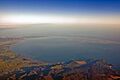
Golden Bay and Farewell Spit from the air
-
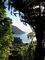
One of many beaches in Abel Tasman National Park


See also
 In Spanish: Golden Bay / Mohua para niños
