Karamea facts for kids
Quick facts for kids
Karamea
|
|
|---|---|
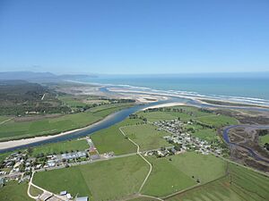
Market Cross, Karamea, and the Ōtūmahana Estuary
|
|
| Country | New Zealand |
| Region | West Coast |
| District | Buller District |
| Ward | Seddon |
| Electorates |
|
| Area | |
| • Total | 66.08 km2 (25.51 sq mi) |
| Population
(June 2023)
|
|
| • Total | 410 |
| • Density | 6.20/km2 (16.07/sq mi) |
Karamea is a small town located on the West Coast of New Zealand's South Island. It is the northernmost town of its size on the West Coast. You'll find it about 96 kilometres (60 mi) northeast of Westport by road.
Karamea is special because it's almost completely surrounded by Kahurangi National Park. This huge park covers the south, east, and north sides of the town. The town itself sits on a flat area near the Karamea River and the Ōtūmahana Estuary.
Karamea is a great place to start exploring Kahurangi National Park. Many visitors come here to hike or mountain bike on the famous Heaphy Track. You can also visit local spots like the Ōpārara Basin, see the amazing Ōpārara Arches, explore the Fenian Track and its caves, or walk the Big Rimu Walk. The beautiful coastal scenery north of Kōhaihai is also a must-see.
Contents
What's in a Name?
The name Karamea comes from the Māori people. Some people joke it was named by an Italian, but that's not true! It's thought to mean "red ochre," which is a type of reddish earth. Another idea is that it's a shorter version of Kakara taramea, which means "the smell of speargrass leaves." The name is used for both the town and the wider area around it.
A Look Back in Time
People have lived in the Karamea area for a very long time. Large piles of shells, called middens, have been found here. These middens show that Māori people lived in the area between the years 1400 and 1600 AD. It seems they used the spot as a temporary camp while traveling down the coast to collect pounamu, a precious greenstone.
The mouth of the Heaphy River was also an important Māori camp, possibly as early as 1380 AD. It was one of the few places in the northwest South Island where people stayed for long periods. They worked with stones, including local pounamu and other types of stone brought from different parts of New Zealand. This area is very important to the Ngāi Tahu Māori tribe, which is why it was kept separate from Kahurangi National Park.
The first Europeans and Chinese people arrived in the 1860s, looking for gold.
Early Settlers and the Earthquake
In the 1870s, the government wanted to develop remote parts of the Nelson Province and attract new people to New Zealand. They created "Special Settlement Areas" where immigrants could get land and jobs. Karamea was chosen because it was known from the gold rush and had a harbour for ships.
The first settlers arrived in Karamea by steamer ship in November 1874. Many of these 20 men had never worked on new land before. They were given small plots of land, and later, better land was found on the river flats. Women and children joined them in January 1875.
Getting to Karamea was hard. A road over the hills, known as the Karamea bluffs, wasn't fully opened until 1916. Before that, people used a difficult and dangerous coastal track.
The Big Earthquake of 1929
On June 17, 1929, a huge earthquake, known as the Murchison earthquake, hit the Karamea area. It caused a lot of damage. All the roads were closed, and most bridges were broken. Houses were badly damaged, and many chimneys fell down. Some houses even burned. The town's wharf was also badly damaged.
The earthquake caused big landslides that cut off the road from Westport, completely isolating Karamea. Telephone lines were also broken. People had to walk all the way from Karamea to Westport to report the damage. The earthquake also made it harder to deal with a sickness outbreak in the town, so medicine had to be flown in by plane.
The earthquake changed the Karamea harbour, making it shallower. It also cut off the road for about two years. Many workers were needed to rebuild the road. During this time, small ships carried people and supplies between Westport and Karamea.
Dairy Farming in Karamea
Dairy farming started in Karamea when the first Karamea Co-operative Dairy Company opened in 1893. This first company didn't last long, but a new one started in 1911. They bought a butter factory and began making butter. In their first year, they produced about 40 tonnes of butter!
Since there was no road out of Karamea back then, all the butter had to be shipped out by sea. By 1935, the factory was making 300 tonnes of butter each year. The dairy industry grew, and from the 1970s, they also made milk powder. Today, milk is no longer processed in Karamea; it's transported by road to Hokitika.
Karamea's Surroundings
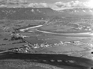
Karamea is about 96 kilometres (60 mi) north of Westport on State Highway 67. The town is on a flat coastal area next to the Karamea River and the Ōtūmahana Estuary. This estuary is part of the Karamea Bight, a large bay that stretches for 100 kilometres (62 mi) north from Cape Foulwind. As mentioned, Karamea is mostly surrounded by Kahurangi National Park.
There are two main parts to Karamea on the north side of the river: Market Cross and Karamea itself. They are about 1 kilometre (0.62 mi) apart. On the south side of the river, about 3 kilometres (1.9 mi) inland, you'll find the small settlements of Arapito and Umere. These places were once called Promised Land and Land of Promise when settlers arrived around 1880.
The mouth of the Ōpārara River is about 5 kilometres (3.1 mi) north of central Karamea. About 17 kilometres (11 mi) south of Karamea is Little Wanganui, a small farming village known for surfing and fishing.
The Ōtūmahana Estuary
The Ōtūmahana Estuary is a large area where the Karamea River, Baker Creek, and Granite Creek meet the sea. It's a shallow area with mudflats and salt marshes, covering about 400 hectares (990 acres). This type of environment is rare in New Zealand and is very important for birds and fish to feed and breed.
It's the third-largest tidal estuary on the West Coast. The West Coast Regional Council has called it a "Significant Wetland." A small protected area, the Ōtūmahana Reserve, was set up in 1983 to help protect this special place.
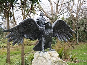
In 2020, a life-size bronze statue of the extinct Haast's eagle (also called hōkioi) was put up in Karamea. This huge eagle was once the largest in the world! The statue is called Te Maia Kahurangi. It shows an ancestor named Te Maia riding an eagle he had raised. This statue represents the spiritual guardian of the estuary and was created by local Māori tribes and a local environmental group.
The Karamea River
The Karamea River and its smaller streams drain an area of about 1,210 km2 (470 sq mi). This is about 23% of the entire Kahurangi National Park.
The river has a history of causing floods in the town. In 1899, a big flood washed away a new bridge and damaged homes and farms. Another major flood in January 1915 covered the main street and most houses.
The 1929 Murchison earthquake caused debris to block the river's mouth. A new path to the sea formed about 1.6 kilometres (0.99 mi) south. This made the riverbed higher, increasing the risk of flooding in Karamea and Market Cross. There were more floods in 1929 and 1931, causing damage to homes.
To protect the town, walls were built along the river. In 1937, a large flood caused the river to break through to the sea at its old mouth. This created a new channel that greatly reduced the flood risk for the town. More protection work was done between 1938 and 1940, which helped during a heavy flood in 1940.
The river's path to the sea has changed a lot over the years. Sometimes there are one or two openings, and they have moved over 4.5 kilometres (2.8 mi) of coastline. In recent years, the channel moved far south, increasing flood risk again. In 2017, new channels were dug to help the river flow directly to the sea, reducing the flood risk.
Protecting the Environment
In July 2020, a local environmental group called Clean Streams Karamea received funding. This money will help them plant 315,000 trees along 80 kilometres (50 mi) of waterways on farms. This project aims to improve the health of the rivers and streams in the area.
Karamea's Weather
| Climate data for Arapito, 3 m (4km SE of Karamea, 1991–2020) | |||||||||||||
|---|---|---|---|---|---|---|---|---|---|---|---|---|---|
| Month | Jan | Feb | Mar | Apr | May | Jun | Jul | Aug | Sep | Oct | Nov | Dec | Year |
| Record high °C (°F) | 33.0 (91.4) |
29.2 (84.6) |
30.2 (86.4) |
26.0 (78.8) |
24.5 (76.1) |
20.3 (68.5) |
19.4 (66.9) |
19.3 (66.7) |
20.7 (69.3) |
23.9 (75.0) |
25.8 (78.4) |
28.0 (82.4) |
33.0 (91.4) |
| Mean daily maximum °C (°F) | 21.0 (69.8) |
21.6 (70.9) |
20.4 (68.7) |
18.1 (64.6) |
15.9 (60.6) |
13.4 (56.1) |
12.9 (55.2) |
13.6 (56.5) |
14.8 (58.6) |
16.0 (60.8) |
17.4 (63.3) |
19.5 (67.1) |
17.1 (62.8) |
| Daily mean °C (°F) | 16.3 (61.3) |
16.7 (62.1) |
15.3 (59.5) |
13.2 (55.8) |
11.2 (52.2) |
8.9 (48.0) |
8.2 (46.8) |
9.0 (48.2) |
10.3 (50.5) |
11.7 (53.1) |
13.0 (55.4) |
15.2 (59.4) |
12.4 (54.3) |
| Mean daily minimum °C (°F) | 11.7 (53.1) |
11.8 (53.2) |
10.3 (50.5) |
8.4 (47.1) |
6.5 (43.7) |
4.5 (40.1) |
3.4 (38.1) |
4.4 (39.9) |
5.9 (42.6) |
7.4 (45.3) |
8.7 (47.7) |
10.9 (51.6) |
7.8 (46.0) |
| Record low °C (°F) | 3.8 (38.8) |
3.8 (38.8) |
1.5 (34.7) |
1.0 (33.8) |
−2.4 (27.7) |
−4.0 (24.8) |
−3.1 (26.4) |
−4.0 (24.8) |
−2.1 (28.2) |
−0.8 (30.6) |
2.3 (36.1) |
−4.0 (24.8) |
−4.0 (24.8) |
| Average rainfall mm (inches) | 177.3 (6.98) |
127.1 (5.00) |
146.5 (5.77) |
175.1 (6.89) |
196.7 (7.74) |
199.3 (7.85) |
183.4 (7.22) |
185.9 (7.32) |
212.4 (8.36) |
239.2 (9.42) |
190.2 (7.49) |
211.4 (8.32) |
2,244.5 (88.37) |
| Mean monthly sunshine hours | 210.3 | 183.4 | 187.5 | 155.7 | 126.7 | 104.1 | 119.6 | 141.7 | 141.7 | 157.5 | 172.4 | 180.1 | 1,880.7 |
| Source: NIWA | |||||||||||||
Who Lives in Karamea?
Karamea town covers about 66.08 km2 (25.51 sq mi). In 2018, about 410 people lived there. The population has seen some changes over the years.
| Historical population for Karamea town | ||
|---|---|---|
| Year | Pop. | ±% p.a. |
| 2006 | 423 | — |
| 2013 | 375 | −1.71% |
| 2018 | 354 | −1.15% |
In 2018, there were 354 people living in Karamea. There were more males (195) than females (159). About 14% of the people were under 15 years old, and 28% were 65 or older.
Most people in Karamea are of European (Pākehā) background (93.2%). Some people also identify as Māori (6.8%), Pasifika (3.4%), or Asian (2.5%).
When asked about religion, most people (61.9%) said they had no religion. About 24.6% were Christian.
For those aged 15 and over, about 9.9% had a university degree or higher. About 37.6% worked full-time, and 20.8% worked part-time.
How Karamea Makes a Living
In 2020, Karamea's economy produced $26.8 million, with 199 jobs in 111 businesses. The main ways people earn money in Karamea are through dairy farming and tourism. About a quarter of the jobs are in service industries, like shops and cafes.
Other jobs in the past included collecting sphagnum moss, controlling possums, fishing, and making fine furniture. Today, some people also grow tomatoes and run plant nurseries. The area has a special mild climate, which means they can even grow fruits like tamarillo.
In 2020, more people were moving to Karamea. This led to a higher demand for houses and more students at the Karamea Area School.
Fun Things to Do in Karamea
Tourists visit Karamea all year round to enjoy the many beautiful sights, especially in Kahurangi National Park. Tourism is growing fast here, and some people call Karamea "New Zealand's best-kept secret."
Amazing Walking Tracks
The southern end of the Heaphy Track, one of New Zealand's nine "Great Walks," is near the Kohaihai River. This is about 20 kilometres (12 mi) north of Karamea. The western end of the Wangapeka Track is also nearby, about 18 kilometres (11 mi) south of Karamea, near Little Wanganui.
Other popular places to visit include the Ōpārara Basin (with its amazing Ōpārara Basin Arches), the Honeycomb Hill Cave, the Fenian Track and its caves, and the Big Rimu Walk.
Mountain Biking Adventures
Karamea is a great starting point for mountain biking trips. Before Kahurangi National Park was created in 1996, mountain biking was very popular on the Heaphy Track. About 2,000 mountain bikers rode the track in the year before it became a National Park.
At first, mountain biking wasn't allowed in National Parks. But people worked hard to bring it back to the Heaphy Track. In 2011, a three-year trial began, allowing mountain biking during the winter months (May to September). This trial was successful, and mountain biking became a permanent option. Now, you can mountain bike the Heaphy Track each year from May 1 to November 30, in groups of up to six riders.
Getting Around Karamea
Karamea is located 96 kilometres (60 mi) north of Westport on State Highway 67. This is the only road connecting the town to the south. The road ends about 20 kilometres (12 mi) north of Karamea, at the Kohaihai River, which is the start of the Heaphy Track.
You can also travel to Karamea by air. Karamea Aerodrome has flights from Karamea to Wellington, Takaka, and Nelson, offered by Golden Bay Air. There's also a helicopter service available at the aerodrome.
What Karamea Offers
Karamea town has many useful services. You'll find a general store, a supermarket, petrol pumps, an information centre, a cafe, a hotel, a camping ground, motels, backpacker hostels, and an art and craft shop.
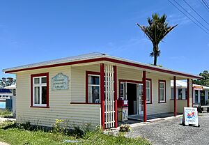
The Karamea War Memorial Library opened in 1954. For many years, it shared its building with the Plunket Society, which helps families with young children. In the 1990s, the library took over the whole building. Today, it's run entirely by volunteers and has about 50 members.
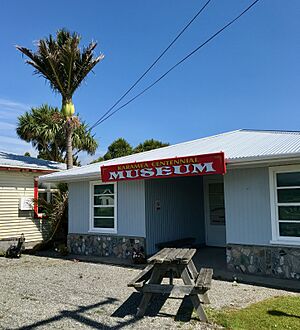
The Karamea Centennial Museum is a small museum that opened in 1974. It has photos and displays about the local industries from the past, like sawmilling (cutting wood), dairying (farming cows for milk), gold mining, flax milling, and shipping.
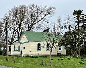
Before 1908, there wasn't a church in Karamea. Services were held in people's homes, and a minister would visit from other towns, often having a difficult journey along the coast. After a sad accident in 1906 where a ship's crew drowned, the local vicar suggested building a memorial. The people of Karamea decided to build a church instead. The Holy Trinity Church was built in three months and opened on June 24, 1908. It has been a community church for everyone ever since.
Learning in Karamea
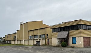
Karamea Area School is a school for all ages, from year 1 to year 13. It has a roll of 87 students. The Ministry of Education considers it one of the four most isolated schools in New Zealand. In 2000, the school celebrated 125 years of schooling in the area. A big rebuild project for the school, costing $11 million, was underway in 2020. This project won a top award for education buildings in 2023.
Famous People from Karamea
Some notable people who have connections to Karamea include:
- Atholl Anderson (born 1943), an archaeologist, who was a teacher at Karamea Area School from 1968 to 1970.
- Sophia Anstice (1849–1926), a businesswoman, lived in Karamea from 1874 to 1878 and started her dressmaking business there.
- Anna Harrison (born 1983), a netball player, grew up in Karamea.
- Owen Jennings (born 1945/46), a Member of Parliament from 1996 to 2002, and a former President of New Zealand Federated Farmers.
 | Frances Mary Albrier |
 | Whitney Young |
 | Muhammad Ali |


