Cook Strait facts for kids
Quick facts for kids Cook Strait |
|
|---|---|
| Māori: Te Moana-o-Raukawa | |
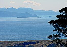
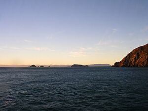
A view from the summit of Mount Kaukau across Cook Strait to the Marlborough Sounds in the distance.
|
|
| Coordinates | 41°13′46″S 174°28′59″E / 41.22944°S 174.48306°E |
| Basin countries | New Zealand |
| Min. width | 22 km (14 mi) |
| Average depth | 128 m (420 ft) |
Cook Strait (called Te Moana-o-Raukawa in Māori) is a famous strait in New Zealand. It separates the North Island from the South Island. This important waterway connects the Tasman Sea in the northwest with the South Pacific Ocean in the southeast. At its narrowest point, the strait is about 22 kilometers (14 miles) wide. It is known for its strong currents and unpredictable weather, making it one of the most challenging waters in the world. Regular ferry services cross the strait, linking Picton in the Marlborough Sounds with Wellington, New Zealand's capital city.
The strait is named after James Cook, a European explorer who sailed through it in 1770. Its Māori name, Te Moana-o-Raukawa, means "The Sea of Raukawa." Raukawa is a type of native New Zealand plant.
Contents
Exploring Cook Strait's Past
Cook Strait has a rich history, from ancient times to modern events.
How Cook Strait Formed
About 18,000 years ago, during the last Ice Age, sea levels were much lower. At that time, Cook Strait was a deep harbor connected to the Pacific Ocean. The North and South Islands were joined by wide coastal plains. As the Earth warmed and sea levels rose about 7,000 years ago, the islands became separated. This created the strait we know today, linking it to the Tasman Sea.
Māori Legends and Discoveries
In Māori legends, the great navigator Kupe is said to have discovered Cook Strait. He chased a giant octopus named Te Wheke-a-Muturangi across the strait in his canoe. He finally defeated the octopus in Tory Channel.
The first European to see New Zealand was Dutch explorer Abel Tasman in 1642. He thought Cook Strait was a bay and named it Zeehaen's Bight. Later, in 1769, James Cook proved it was a strait, a navigable waterway.
Early European Settlements
In the early 1800s, European settlers were drawn to Cook Strait. It was a route for whales, so whalers set up bases in the Marlborough Sounds. Arapaoa Island was a major whaling spot from the 1820s to the 1960s.
Around the 1820s, Te Rauparaha led a Māori migration to the Cook Strait area. More permanent settlements began in 1840, including Wellington and Nelson. For early settlers, Cook Strait was the central waterway of the new colony.
Important Events and Milestones
- 1866: The first telegraph cable was laid across Cook Strait. This connected the South Island to Wellington.
- 1888-1912: A friendly Risso's dolphin named Pelorus Jack became famous. He would meet and guide ships through the strait. He was even protected by a New Zealand law in 1904.
- World War II Defenses: During the Second World War, forts were built to protect Cook Strait. Large guns were placed on Wrights Hill Fortress near Wellington. Many of these old fortifications can still be seen today.
- Lighthouses: The Pencarrow Head Lighthouse was New Zealand's first permanent lighthouse. Its first keeper, Mary Jane Bennett, was the only female lighthouse keeper in the country's history.
- Shipwrecks: Cook Strait has seen many shipwrecks over the years. Notable disasters include the Maria (1851), the City of Dunedin (1865), the SS Penguin (1909), and the TEV Wahine (1968). These events led to significant loss of life.
Cook Strait Timeline
- 1642: Abel Tasman mistakenly thought Cook Strait was a bay.
- 1769: James Cook confirmed it was a strait.
- 1822: The Ngāti Toa tribe moved to the Cook Strait region, led by Te Rauparaha.
- 1831: A whaling station was set up in Tory Channel.
- 1855: A severe earthquake hit both sides of Cook Strait.
- 1866: The first submarine telegraph cable was laid across the strait.
- 1904: Pelorus Jack the dolphin was protected by New Zealand law.
- 1909: The SS Penguin sank in Cook Strait, killing 75 people.
- 1920: The first airplane flight crossed Cook Strait.
- 1962: The Cook Strait rail ferry service began.
- 1962: Barrie Devenport became the first person to swim the strait.
- 1964: Electric power cables were laid across Cook Strait.
- 1968: The TEV Wahine sank at the entrance to Wellington Harbour, killing 53 people.
- 1975: Lynne Cox became the first woman to swim the strait.
- 1979: Paul Caffyn crossed the strait in a sea kayak.
- 1984: Philip Rush swam the strait both ways.
- 1991: Five new power and communication cables were laid.
- 2013: Two large earthquakes (magnitudes 6.5 and 6.6) struck Cook Strait.
- 2021: The first electric aircraft flight crossed Cook Strait.
Geography of Cook Strait
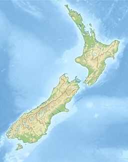
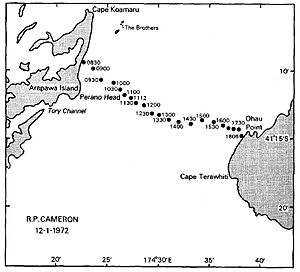
Cook Strait generally runs from northwest to southeast. The South Island is on the west side, and the North Island is on the east. The narrowest part is 22 kilometers (14 miles) wide, between Cape Terawhiti (North Island) and Perano Head on Arapaoa Island (South Island). On a clear day, you can easily see across the strait.
The South Island coast stretches about 30 kilometers (19 miles) along Cloudy Bay and past the Marlborough Sounds. The North Island coast runs about 40 kilometers (25 miles) along Palliser Bay, past Wellington Harbour, and continues to Mākara Beach.
Islands and Underwater Features
The Brothers are a group of small islands off Arapaoa Island. North Brother island is a special home for the rare Brothers Island tuatara, a reptile unique to New Zealand. The largest of these islands has the Brothers Island Lighthouse.
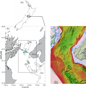
The shores of Cook Strait are mostly steep cliffs. The seafloor is complex. To the east is the Cook Strait Canyon, which drops steeply into the deep Hikurangi Trench. To the northwest is the Narrows Basin, where the water is 300 to 400 meters (980 to 1,300 feet) deep. The average depth of the strait is 128 meters (420 feet).
Oceanography: Understanding the Waters
The waters of Cook Strait are known for their very strong tidal flows. The tides at each end of the strait are almost exactly opposite. This means when it's high tide on one side, it's low tide on the other. This difference in sea level creates powerful currents, which can reach speeds of 2.5 meters per second (5 knots).
Even with these strong currents, the tidal height change in the middle of the strait is almost zero. Sometimes, a strong current might flow in one direction for many hours, even longer than usual. This makes the strait's currents very complex and sometimes unpredictable.
Tidal Power: Harnessing the Ocean's Energy
Cook Strait is considered an excellent place to generate tidal energy. This is because the power generated by tidal turbines increases greatly with faster currents.
In 2008, a company called Neptune Power received permission to install an experimental underwater tidal stream turbine. This turbine was designed to produce one megawatt of power. It was planned for an area known as the "Karori rip," south of Sinclair Head. The company believed there was enough tidal movement in Cook Strait to generate a huge amount of power, more than New Zealand's needs at the time. However, this turbine has not yet been built.
Another company, Energy Pacifica, also planned to install up to 10 marine turbines near the entrance to Tory Channel. They claimed this area had very fast tidal currents, making it ideal for power generation. But this project also did not move forward.
Cables: Connecting the Islands
Electric power and communication cables cross Cook Strait, connecting the North and South Islands. These are managed by Transpower.
Power Cables
Three large submarine power cables cross the strait. They are part of the HVDC Inter-Island link, which carries electricity between Benmore in the South Island and Haywards in the North Island. Each cable can carry a lot of power, and the total capacity of the link is 1200 megawatts. These cables lie on the seabed within a special "cable protection zone" (CPZ). Fishing and anchoring boats are not allowed in this zone to protect the cables.
Communication Cables
Fibre optic cables also run across Cook Strait. These cables carry telecommunications for New Zealand's main phone and internet companies. They also help Transpower control the electricity link.
Marine Life: Who Lives in the Strait?
Cook Strait is a vital home for many sea creatures, especially cetaceans (whales and dolphins).
Dolphins and Whales
Several types of dolphins, like bottlenose, common, and dusky dolphins, are often seen here. Killer whales and the unique Hector's dolphin also live in these waters. Long-finned pilot whales sometimes get stranded in large groups in Golden Bay.
The famous Pelorus Jack was a Risso's dolphin who guided ships between 1888 and 1912. Large migratory whales, like humpback whales, used to attract many whalers to the area in winter. Today, the Department of Conservation conducts annual surveys to count humpback whales. Other occasional visitors include southern right whales, blue whales, and sperm whales.
Other Sea Creatures
Giant squid have been found washed ashore around Cook Strait or in the stomachs of sperm whales. A group of male fur seals lives near Red Rocks on the south Wellington coast. Cook Strait is also a good place for game fishing. You can catch albacore tuna, broadbill swordfish, bluenose, mako sharks, and sometimes marlin and white sharks.
Transport: Crossing the Strait
Regular ferry services operate between Picton and Wellington. These are run by KiwiRail (the Interislander) and StraitNZ (Bluebridge). Both companies offer several trips each day. The journey covers about 70 kilometers (43 miles) and takes around three hours. About half the trip is in the open strait, and the rest is within the calmer Marlborough Sounds.
Challenging Conditions
Cook Strait often experiences rough water and strong winds, especially from the south. New Zealand's location in the "Roaring Forties" means the strait funnels westerly winds, turning them into strong northerlies. Because of this, ferry crossings can be disrupted, and Cook Strait is known as one of the most dangerous and unpredictable waters in the world.
In 1968, the ferry TEV Wahine sank at the entrance to Wellington Harbour. Of the 733 people on board, 53 died. In 2006, 14-meter (46-foot) waves caused the Interislander ferry DEV Aratere to tilt sharply. Several passengers and crew were injured, and vehicles were damaged.
Airlines like Straits Air Freight Express and Sounds Air also operate flights across Cook Strait.
Swimming the Strait
According to Māori oral tradition, the first woman to swim Cook Strait was Hine Poupou. She swam from Kapiti Island to D'Urville Island with the help of a dolphin.
In modern times, Barrie Devenport was the first person to swim the strait in 1962. Lynne Cox was the first woman to complete the swim in 1975. The swimmer who has crossed the strait the most times is Philip Rush, with eight crossings, including two double crossings (swimming both ways).
The youngest swimmer was Aditya Raut, at 11 years old. Caitlin O'Reilly was the youngest female swimmer and youngest New Zealander, at 12 years. Pam Dickson was the oldest swimmer at 55 years. John Coutts was the first person to swim the strait in both directions. By 2010, 74 single crossings had been made by 65 people, and three double crossings by two people. In 2016, Marilyn Korzekwa became the first Canadian and oldest woman (at 58) to swim the strait.
The strong and unpredictable currents in Cook Strait greatly affect how long it takes swimmers to cross.
Images for kids
See also
 In Spanish: Estrecho de Cook para niños
 | Madam C. J. Walker |
 | Janet Emerson Bashen |
 | Annie Turnbo Malone |
 | Maggie L. Walker |


