
Mount Kaukau facts for kids
Quick facts for kids Mount Kaukau |
|
|---|---|
 |
|
| Highest point | |
| Elevation | 445 m (1,460 ft) |
| Naming | |
| Native name | Tarikākā (Māori) |
| Geography | |
| Country | New Zealand |
| State/Province | Wellington |
Mount Kaukau is a well-known hill in the northern part of Wellington, New Zealand. It's close to suburbs like Johnsonville, Khandallah, and Ngaio. The top of Mount Kaukau is 445 meters (about 1,460 feet) above sea level. It's easy to spot because of Wellington's main television tower, which stands 122 meters tall near the summit.
From the top, you can see amazing views of the city, the harbour, and distant mountain ranges like the Remutaka and Tararua. On a clear day, you might even see the Kaikoura Ranges in the South Island. To the northwest, you can see the Porirua Basin and the Tasman Sea.
Contents
What's in a Name? The History of Mount Kaukau
The original Māori name for this hill is Tarikākā. This name means 'where the parrots rested'. A nearby area in Ngaio, at the base of the mountain, shares this name. Long ago, before the native Totara forest was cleared, a native parrot called the kaka was very common here.
Today, more than a hundred years later, the kaka population is growing again. This is thanks to efforts at places like Zealandia. You can now see these parrots more often around Wellington and in the regrowing native forests on Mount Kaukau.
Exploring Mount Kaukau's Slopes and Surroundings
A large part of the eastern side of Mount Kaukau is called Khandallah Park. This park is one of New Zealand's oldest, started in 1888. It became an official park in 1909. Khandallah Park has over 60 hectares (about 150 acres) of native forest.
When you walk through the forest, you might see native birds like the kereru (New Zealand pigeon), tui, and fantail. You can also spot the old stumps of large totara trees, especially in the lower parts of the forest. Mount Kaukau is also part of the Northern Skyline track, a walking path that goes from Johnsonville to Karori and Makara.

Fun Activities on Mount Kaukau
Khandallah Park offers 9 kilometers (about 5.6 miles) of walking tracks. These tracks let you reach the peak of Mount Kaukau from different suburbs like Khandallah, Johnsonville, Ngaio, and Crofton Downs. Some of these tracks are also open for mountain biking and e-biking, which is a great way to explore the area.
-
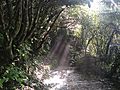
View of Northern Walkway (descending Mt Kaukau)
-
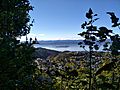
View of Matiu / Somes Island from Mt Kaukau track
-
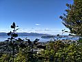
View of Miramar Peninsula from Mt Kaukau track
.jpg)
_Island_from_Mt_Kaukau_track.jpg)

The Mount Kaukau Television Tower

The tall 122-meter (about 400-foot) television tower on Mount Kaukau was built in 1965. It was made to send out signals for the television channel WNTV1. This new tower greatly improved TV coverage compared to the older one at Mount Victoria. Today, this tower is super important. It's the main place that sends out television and FM radio signals for the whole Wellington area.
The Kaukau Challenge Race
Every year, Khandallah School, which is located at the base of Mount Kaukau, organizes a fun event called the Kaukau Challenge. This event is a fun walk or run from the school all the way to the summit of Mount Kaukau and back down. The Kaukau Challenge has been an annual event since 2006, with around 500 people joining in each year. It's a great way for the community to get active and enjoy the mountain.
Rare Snowfall on Mount Kaukau
In August 2011, something very unusual happened: it snowed a lot in Wellington! Two local men, Nick Fone and Daniel McFadyen, took advantage of this rare event. They claimed to be the first people to ski and snowboard down Mount Kaukau. Wellington usually has mild weather, so snow falling close to sea level is extremely rare. It happens less often than once every 15 years.
Images for kids
-
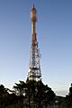
Close-up of the Mount Kaukau television transmitter
