
Matiu / Somes Island facts for kids
|
Matiu (Māori)
|
|
|---|---|

Matiu/Somes Island as seen from Mount Kaukau
|
|

Matiu/Somes Island
Location in New Zealand Wellington
Matiu / Somes Island (New Zealand Wellington)
|
|
| Geography | |
| Location | Wellington Harbour |
| Coordinates | 41°15′29.7″S 174°51′55.4″E / 41.258250°S 174.865389°E |
| Area | 0.249 km2 (0.096 sq mi) |
| Administration | |
Matiu/Somes Island is the biggest of three islands in the northern part of Wellington Harbour, New Zealand. It is about 24.9 hectares (61.5 acres) in size. The island lies 3 kilometers (1.9 miles) south of Petone and the mouth of the Hutt River. It is also about 5 kilometers (3.1 miles) northwest of the smaller Makaro/Ward Island.
Contents
The Names of Matiu/Somes Island

Long ago, Māori legends say that both Matiu and Makaro Islands got their names from Kupe. He was a famous navigator who first reached New Zealand. He named the islands after his two daughters (or nieces) when he sailed into the harbour about 1000 years ago.
After Europeans arrived, the island was called Somes Island for over 100 years. In 1839, it became part of the New Zealand Company's land. They named it after Joseph Somes, who helped fund the company. But in 1997, the New Zealand Geographic Board gave it the official name Matiu/Somes. This name honors both its Māori and European past.
Matiu/Somes Island's History
Matiu/Somes Island has a long and interesting history. It includes important Māori stories and a varied European past.
Māori History on the Island
Before the mid-1600s, there were two Māori pā (fortified villages) on the island. These pā were not lived in all the time. They were "pā of refuge" where people could go for safety during wars.
One pā was in the middle of the island. Today, only small remains of old food waste (middens) are left there. The other pā was at the northern tip of the island. It was a great spot for defense because it had cliffs on three sides.
European History on the Island


A lighthouse was built on the island's southwest side in 1866. It was the first harbour light in New Zealand. The lighthouse you see today was built in 1900 and later became automatic.
For many years, the island was used for different things. During wars, it held people who were considered "enemy aliens." It also had quarantine facilities. These were places where new arrivals, both people and animals, had to stay. This was to make sure they did not bring diseases into the country. This use continued for animals until 1995.
For example, in 1872, a ship arrived with people who had smallpox. These passengers and crew had to stay on the island in temporary shelters.
During World War I, the island became an internment camp. About 300 "enemy aliens" were held there. These were often German prisoners of war or people suspected of being a threat.
In 1942, during World War II, the island was made stronger. Heavy anti-aircraft guns were placed on the top. However, these guns were never used in the war. To build these, 17 meters (56 feet) was removed from the island's highest point. A special station was also built to protect ships from magnetic mines. You can still see many of these old sites on the island today.
In 1989, Matiu/Somes became part of Lower Hutt. In August 1995, the New Zealand Department of Conservation ("DOC") took full control. It is now a special scientific and historic reserve.
You can take a ferry to Matiu/Somes Island from the Wellington CBD and Days Bay every day. On weekends, ferries also go from Seatoun.
Island Geography and Ecology

A clear gully (a small valley) runs from the south of the old quarantine station to the sea. This area is often swampy. When it rains a lot, a small creek flows down it.
The island is a safe home for many native animals. These include the little blue penguin, several types of shag (a type of bird), and the spotted skink (a lizard). You can also find the silver gull and several rare and endangered plant species here.
The Royal Forest and Bird Protection Society of New Zealand has been planting new trees and plants on the island since 1984. They successfully removed rats and mice between 1988 and 1989. This made the island safer for native wildlife.
In 2004, eleven male red-crowned kākāriki (parakeets) were brought to the island. They started breeding right away! Another eleven were released in 2005. The island is also home to over 500 types of invertebrates (animals without backbones). These include two kinds of wētā (large insects): Wellington tree wētā and Cook Strait giant wētā. These wētā were moved from Mana Island. Many endangered plants have also found a safe place on the island.
Today, the island has six types of native reptiles. These are the common skink, spotted skink, copper skink, and the common gecko. Brothers Island tuatara were released in 1998. Forest geckos were moved to the island in 2006. North Island robins from Kapiti Island were released in April 2006. They started breeding that September, which is great news for conservationists. It shows the island is a good home for them. A special solar-powered speaker system was also set up to attract fluttering shearwaters (seabirds).
Many of these projects have been helped by the local community and the iwi (Māori tribe), Te Ati Awa. The Matiu/Somes Island Charitable Trust was started in 1998. It works with Te Ati Awa and the community to protect the island. They raise money for projects that help nature and make visits more enjoyable.
Visiting Matiu/Somes Island
Matiu/Somes Island is becoming a very popular place to visit. About 15,000 people come each year. It is also used as a learning place for local schools.
The island is free of introduced animal pests like stoats (a type of weasel). This is very important for the native wildlife. Visitors must make sure they do not bring any pests with them. Before arriving, you need to check, clean, and seal all your bags and gear. This stops any pests, soil, or seeds from getting onto the island.
Close by, to the north, is a much smaller island called Mokopuna Island. To protect the special wildlife there, especially nesting seabirds, people are not allowed to land on Mokopuna Island.
Images for kids
-
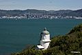
Lighthouse with Wellington City in the background
.jpg)
