Petone facts for kids
Quick facts for kids
Petone
|
|
|---|---|
|
Suburb
|
|
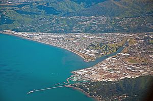
Aerial view of Petone and Seaview
|
|
| Country | New Zealand |
| Local authority | Lower Hutt |
| Electoral ward | Harbour |
| Established | 1840 |
| Area | |
| • Land | 390 ha (960 acre) |
| Population
(June 2023)
|
|
| • Total | 8,330 |
| Postcode(s) |
5012
|
| Train station(s) | Petone Railway Station Ava Railway Station |
|
|
||
Petone (in Māori: Pito-one) is a large suburb in Lower Hutt, Wellington. It is located at the southern end of the Hutt Valley, on the northern shore of Wellington Harbour. European settlers first arrived in Petone in January 1840. This makes it the oldest European settlement in the Wellington Region.
Petone became a borough in 1888. It later joined with Lower Hutt (also known as "Hutt City") in 1989. In November 2023, the Hutt City Council decided to ask the New Zealand Geographic Board about changing the suburb's name to "Pito-one." This is the area's original Māori name.
Contents
- Understanding the Name Petone
- Petone's Location and Landscape
- A Look Back at Petone's Past
- Petone's Population and People
- Places to Visit in Petone
- Petone Rotary Fair: A Community Event
- Schools and Learning in Petone
Understanding the Name Petone
The Māori name Pito-one means "an umbilical cord (pito) buried in the sand (one)." This name is a symbol of connecting a newborn to the whenua (land) in Māori culture.
On September 6, 2024, the Hutt City Council voted to officially rename the suburb "Pito One." This proposed name change was supported by the New Zealand Geographic Board. It also had support from the Wellington Tenths Trust and the Palmerston North Māori Reserve Trust. However, on December 19, 2024, Minister for Land Information Chris Penk stopped the council's decision. He said that "people feel strongly about the name of their home."
Petone's Location and Landscape
Petone is built on flat land. It sits between the Hutt River to the north and east, hills to the west, and Wellington Harbour to the south. The land along the shore rose by about a metre or more during the 1855 Wairarapa earthquake. This helped improve drainage around the Hutt River mouth.
The shore has a shallow, sandy beach. It is formed by sand and dirt from the Hutt River. This beach is a popular place for families to swim. The Korokoro Stream flows down from the hills on the western side of Petone. Because Petone is low-lying, it can be affected by tsunamis and floods. During a big storm on December 20, 1976, the Korokoro Stream caused floods almost a metre deep. This happened in the industrial area of Petone near Cornish Street. More than 40 people had to be rescued from factory roofs.
A Look Back at Petone's Past
When the first European settlers arrived, there were two Māori pā (fortified settlements) belonging to Te Āti Awa near the beach at Pito-one. The Pito-one pā was at the western end of the beach. The Hikoikoi pā was at the other end, near the Hutt River mouth. In 1850, the Pito-one pā was described as "the largest and best fortified" in the Wellington area. Its people grew kumara (sweet potato) and maize. They were considered "better off" than other local Māori. The total population of this pā was 136 people.
Edward Jerningham Wakefield described the area as a "sandy beach, which is about two miles long." He noted the Hutt River at the eastern end and the "merry brawling stream" called the Korokoro. The valley was surrounded by wooded hills. It was covered with thick forest, except for swamps and sand dunes near the beach.
Petone was the very first European settlement in the Wellington region. It still has many historic buildings and landmarks. The first large group of European settlers arrived on January 22, 1840, on the ship Aurora. This ship brought 25 married couples, 36 single people, and 40 children. The Aurora is remembered at the Petone Settlers Museum. The museum has a sculpture shaped like the front of a ship sticking out from its building. Māori from the nearby Pito-one pā came to meet the new arrivals. One passenger wrote in his diary about meeting Chief Te Puni and his family.
A small settlement of wooden houses and tents was built on the beach. It was first called Britannia. Life was hard for the early European settlers. However, the settlement grew. In 1845, the population of "Pito-one and Hutt" was 649. This was smaller than the "Town of Wellington," which had 2,667 people. Horse races were held at Pito-one Beach on October 20, 1842. Five or six hundred people from Wellington came to watch.
After many floods, most settlers moved south around the harbour to Thorndon. Thorndon is now part of the city of Wellington, New Zealand's capital.
From the late 1800s and for most of the 1900s, Petone was a busy town. Many working-class families lived there. It had several large factories. These included car assembly plants, a meat processing plant, and factories for wool, tobacco, soap, and toothpaste. Most of these factories closed in the 1970s and 1980s. This led to a slow economic decline in the area.
Railway worker and photographer Albert Percy Godber (1875-1949) took many photos of Petone. He captured images of railway lines, trains, factories, Māori artworks, and workers. His photos show what Petone was like in an earlier time. The Alexander Turnbull Library has a collection of his photographs.
Factories That Once Thrived
Many large industries once operated in Petone, providing jobs and shaping the town. Here are some of the major ones that have since closed:
- Petone Railway Workshops (1876–1929)
- Gear Meat Company (1882–1981)
- Wellington Woollen Manufacturing Company (1883–1968)
- Lever Brothers soap factory (later Unilever) (1919–2015)
- W.D. & H.O. Wills tobacco factory (1919–2020)
- New Zealand Motor Bodies vehicle assembly plant (1926–1978)
- General Motors vehicle assembly plant (1926–1984)
- Todd Motors vehicle assembly plant (1935–1974)
- Colgate-Palmolive toothpaste and toiletries factory (1939–2007)
- Austin Motor Industries vehicle assembly plant (later New Zealand Motor Corporation) (1946–1983)
Petone became a borough in 1888. The borough's first coat of arms showed images of the Gear Meat Company, the woollen mills, and the railway workshops. This shows how important these businesses were to the local economy. Petone Borough joined with Lower Hutt in 1989 due to local government changes. Since then, the suburb has seen new economic growth. It uses its early European history to attract tourists and now has many cafes and shops.
Petone is also home to the Petone Rugby Club, which started in 1885.
New Zealand's First State Homes
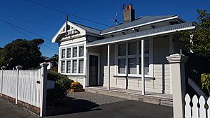
New Zealand's first state housing was built in Petone in 1906. Some of these original houses are still in good condition today. The local tourist office offers a guide showing where these houses are located. Star Flats (apartment blocks built in the 1960s) are found on Jackson Street and East Street. Historian Ben Schrader believes this housing might have been the first national government-led housing development in the world.
Petone's Population and People
Petone includes the areas of Petone Central, Petone East, and Petone Esplanade. It covers about 3.90 square kilometres. As of 2023, it has an estimated population of 8330 people. This means there are about 2136 people per square kilometre.
| Historical population | ||
|---|---|---|
| Year | Pop. | ±% p.a. |
| 2006 | 6,546 | — |
| 2013 | 6,675 | +0.28% |
| 2018 | 7,491 | +2.33% |
In the 2018 New Zealand census, Petone had 7,491 people. This was an increase of 816 people (12.2%) since the 2013 census. There were 2,955 households. The population included 3,753 males and 3,738 females. About 15.6% of people were under 15 years old.
The ethnic makeup of Petone was:
About 28.0% of people were born overseas. This is similar to the national average of 27.1%.
Regarding religion, 48.4% had no religion. 35.0% were Christian. Other religions included Māori religious beliefs (1.2%), Hindu (4.9%), Muslim (0.8%), and Buddhist (0.9%).
Of those aged 15 or older, 32.4% had a bachelor's degree or higher. 13.5% had no formal qualifications. About 22.8% earned over $70,000, which is higher than the national average of 17.2%. Most people (54.8%) were employed full-time.
Places to Visit in Petone
Exploring Jackson Street
Jackson Street is Petone's main street. It has over 220 businesses, many of which are unique local shops. It's a great place for food and drinks, and parking is free. Heritage New Zealand lists Jackson Street as a historic area.
Petone's old police station and jail, built in 1908, were moved to Jackson Street in 1994. The old police station is now the office for the Jackson Street Programme Inc. (JSP). This group helps visitors learn about Jackson Street and Petone. The Old Jail is now a museum. It has exhibits about policing in Petone and the history of the street.
Jackson Street also has a 'Walk of Champions'. Over 140 bronze plaques are set into the footpath. They celebrate 200 local sportspeople who have represented New Zealand or become national champions.
Historic Churches of Petone
St David's Church
St David's is a Presbyterian church located at 4 Britannia Street. It is listed as a Heritage New Zealand Category 2 building. It was built in 1889 in a simple Colonial Gothic style, designed by Christian Toxward. The church originally had a tall steeple, but it was removed after being damaged by weather. In 1993, the steeple was restored. The church has a decorated pipe organ and a large stained glass memorial window. Today, the church is used for services by the Samoan community.
St Augustine's Church
St Augustine's is an Anglican church at 12 Britannia Street. It also has a Heritage New Zealand Category 2 listing. The church is made of wood and was designed by Frederick de Jersey Clere in a gothic style. When it was built in 1902-1903, it had the tallest spire in New Zealand. However, the spire was removed in 1954 after a storm damaged it.
Te Puna Wai Ora: The Spring of Life
The Te Puna Wai Ora (Spring of Life) in Buick Street offers pure, untreated artesian water from taps. This water comes from the Hutt River at the Taita Gorge. It is naturally filtered through the gravel and sands of the Hutt Valley over several years. This makes it safe to drink in its natural form. The water is free, and many people travel long distances to collect it for drinking.
Petone Settlers Museum: A Glimpse into History
The Petone Settlers Museum is located in the Wellington Provincial Centennial Memorial Building. This building is on the Petone foreshore, across from Buick Street. It opened on Wellington Anniversary Day in 1940. It was built to remember the arrival of the ship Aurora and the first European settlement in Wellington. It is a very important historical building.
Iona Cross: A Memorial
In February 1940, a stone cross was put up on the Petone foreshore near the Settlers Museum. It marks 100 years since the first Presbyterian church service in New Zealand. This service was held on board the settler ship Bengal Merchant at Petone on February 23, 1840. The cross is 2.7 metres (about 9 feet) high and has carvings on one side. It was meant to be a copy of the MacLean Cross in Scotland. However, because of World War 2, this was not possible. Instead, the cross was carved in New Zealand from a type of rock called Coromandel Tonalite. This cross is listed as a 'Historic Place Category 2' by Heritage New Zealand.
Hōniana Te Puni-kōkopu Memorial
The Hōniana Te Puni-kōkopu memorial can be found in the Te Puni Street urūpa (burial ground).
Hōniana Te Puni Reserve
Hōniana Te Puni Reserve is a 5-hectare grassy area at the western end of the Petone foreshore. This reserve was once known as 'Korokoro Gateway'. In 2009, it was given to Taranaki Whānui ki Te Upoko o Te Ika as part of a Treaty settlement. The Hutt City Council now manages it. The Wellington Rowing Association and Wellington Water Ski Club have buildings here. The reserve is popular for walking and as a dog exercise area.
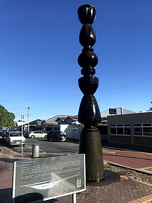
A pouwhenua (carved pole) was put up in the reserve in 2000. The pouwhenua represents Chief Honiana Te Puni. It also remembers the arrival of the first European settlers in Petone. It was carved by Bryce Manukonga of Te Āti Awa. The pouwhenua was repaired and put back in the reserve in 2019. As of 2023, the reserve is being used by workers building Te Ara Tupua. This is a cycleway connecting Petone and Wellington.
Hikoikoi Reserve
The Hikoikoi Reserve is a park and walkway at the mouth of the Hutt River. It has a disc-golf course. This reserve was once the site of Ngati Awa's Hikoikoi Pa.
Petone Wharf: A Link to the Past
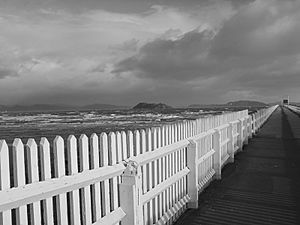
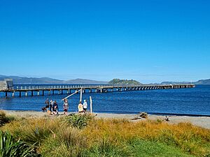
One remaining part of Petone's industrial history is the Petone Wharf. The first wharf was built so the Gear Meat Works could quickly move its products to Wellington for export. That wharf was taken down, and the current wharf was built a bit further north along the shore in 1908-1909.
The wharf was popular for walking and fishing. However, it was closed to the public in January 2021. This was after it was damaged by the 2016 Kaikōura earthquake and two smaller earthquakes. In May 2021, the Hutt City Council voted to repair the wharf. But as of November 2023, the Hutt City Council announced that it would be taking the wharf down.
Petone Rotary Fair: A Community Event
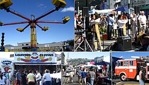
The Petone Rotary Fair is a well-known local event. It has been held every year since 1992. People from all over the greater Wellington region come to Jackson Street for the fair. Jackson Street is closed to traffic for the event.
The fair aims to make Petone more famous and provide a fun day out. It also raises money for charity. The fair has many stalls selling things like plants, artwork, jewellery, CDs & DVDs, and food and drinks. There are also musicians, carnival rides, and displays from groups like the New Zealand Fire Service.
Schools and Learning in Petone
Petone has three schools for younger students:
- Petone Central School is a state primary school (Year 1–8) in central Petone. It has 129 students.
- Sacred Heart School is a state-integrated Catholic primary school (Year 1–8) in central Petone. It has 154 students.
- Wilford School is a state primary school (Year 1–8) in north-eastern Petone. It has 196 students.
Petone College (formerly Hutt Valley Memorial Technical College) closed in 1998. Now, Hutt Valley High School in central Lower Hutt is the closest state secondary school for Petone students.
The main campus of the Wellington Institute of Technology (Weltec) is also located in Petone.
 | Aaron Henry |
 | T. R. M. Howard |
 | Jesse Jackson |


