
1855 Wairarapa earthquake facts for kids

 |
|
| Local date | 23 January 1855 |
|---|---|
| Local time | 21:00 |
| Magnitude | 8.2 Mw |
| Depth | 33 km |
| Epicenter | 41°12′S 175°12′E / 41.20°S 175.20°E |
| Areas affected | New Zealand, North Island |
| Casualties | 7–9 deaths |
The 1855 Wairarapa earthquake was a very powerful earthquake that shook a large part of New Zealand on January 23, 1855. It happened around 9 p.m. and affected areas like Wellington and Wairarapa in the North Island, and Marlborough in the South Island. Near Wellington, where the earthquake started, the ground shook for at least 50 seconds.
Scientists believe this earthquake had a magnitude of 8.2. This makes it the strongest earthquake recorded in New Zealand since Europeans began settling there in 1840. This event caused the ground to move a huge distance, up to 18 meters, along a fault line. It even helped a famous scientist, Charles Lyell, understand how earthquakes are linked to sudden movements of the Earth's crust.
Contents
Understanding New Zealand's Earthquakes
New Zealand sits on the edge of two huge pieces of the Earth's crust called tectonic plates. These are the Australian Plate and the Pacific Plate. These plates are always moving, but very slowly.
In the South Island, most of this movement happens along a big fault called the Alpine Fault. In the North Island, the movement is mainly taken up by the Kermadec subduction zone. This is where one plate slides under another. The remaining movement happens along a group of faults called the North Island Fault System (NIFS). The 1855 earthquake happened on the Wairarapa Fault, which is part of the NIFS.
What Happened During the Earthquake?

The 1855 earthquake caused a long section of the Wairarapa Fault to break. This break was about 150 kilometers (93 miles) long. The ground moved sideways by up to 18 meters (59 feet). This is a very large movement for an earthquake.
At the same time, the Rimutaka Range on one side of the fault was lifted up. The ground rose about 6 meters (20 feet) near the fault. This uplift slowly decreased closer to the western coast of Wellington. Scientists think the earthquake was so big because the fault rupture went deep down. It connected to where the Pacific Plate slides under the Australian Plate.
Evidence from the land, like old uplifted beach ridges at Turakirae Head, shows that similar big earthquakes have happened here before. They seem to occur about every 2200 years.
Damage and Changes to the Land
Wellington felt very strong shaking during the earthquake. However, the damage was not as bad as it could have been. This is because the city had been rebuilt with mostly wooden buildings after another earthquake in 1848. Only one person died in Wellington, in a brick building. Reports say that at least four, and possibly up to eight, other people died in the countryside nearby. Many landslides also happened along the hills of the Rimutaka Range. Some minor damage was even reported far away in places like Lyttelton and Christchurch.
The earthquake also lifted up the northwestern side of Wellington Harbour. This made many of the docks unusable. But this new land was also helpful. It created a new path for roads and railways to the north. Today, much of Wellington's city center is built on land that was lifted out of the harbor by this earthquake. You can see special plaques around the city that show the original 1840 shoreline.
The Tsunami That Followed
The 1855 earthquake also caused New Zealand's largest historical tsunami that was created locally. A tsunami is a series of very large ocean waves caused by an earthquake or other underwater disturbance. These waves reached a height of 10 to 11 meters (33 to 36 feet) in some places.
New Zealand's National Institute of Water and Atmospheric Research (NIWA) created a computer model to show what the 1855 tsunami would have looked like. This simulation was even shown on a TV show called "Aftershock."
Images for kids
-
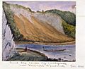
1855 painting of landslip near Newlands by Charles Emilius Gold

