
Wellington Region facts for kids
Quick facts for kids
Greater Wellington
(Wellington Region) Te Upoko o te Ika a Māui (Māori)
|
|
|---|---|
|
Region
|
|

Greater Wellington within the North Island, New Zealand
|
|
| Country | New Zealand |
| Island | North Island |
| Established | 1989 |
| Seat | Wellington |
| Territorial authorities | |
| Government | |
| • Body | Greater Wellington Regional Council |
| Area | |
| • Land | 8,049.44 km2 (3,107.91 sq mi) |
| Population
(June 2023)
|
|
| • Region | 550,500 |
| GDP | |
| • Total | NZ$ 44.987 billion (2021) |
| • Per capita | NZ$ 82,772 (2021) |
| Time zone | UTC+12:00 (NZST) |
| • Summer (DST) | UTC+13:00 (NZDT) |
| ISO 3166 code | NZ-WGN |
| HDI (2021) | 0.958 very high · 1st |
| Website | GW.govt.nz |
Greater Wellington, also known as the Wellington Region, is a large area at the very bottom of New Zealand's North Island. In the Māori language, it is called Te Upoko o te Ika, which means "the head of Māui's fish."
This region covers about 8,049 square kilometers. It is home to over 520,000 people. The region gets its name from Wellington, which is New Zealand's capital city and the main city in the region.
Most people in Greater Wellington live in the main urban area. This includes the cities of Wellington, Porirua, Lower Hutt, and Upper Hutt. Other important towns are along the Kāpiti Coast and Masterton.
Contents
Understanding the Wellington Region
The terms "Wellington region" and "Greater Wellington" can sometimes be a bit confusing. People often use them to mean just the main cities and towns. Areas further out, like the Wairarapa to the east, are sometimes seen as separate.
The Kāpiti Coast is another area sometimes thought of differently. For example, the town of Ōtaki has strong links to the Horowhenua district, which is to its north.
History of Wellington
The Māori people were the first to live in this area. They called it Te Upoko o te Ika a Māui, meaning "the head of Māui's fish." A legend says that the explorer Kupe found and explored this region around the 10th century.
Europeans began to settle here in 1839. This happened when the New Zealand Company arrived. Wellington became the capital of the Wellington Province in 1853. Later, in 1865, Wellington became the capital city of all New Zealand. It was the third capital, after Russell and Auckland.
Exploring Wellington's Geography


The Wellington region is at the southern tip of the North Island. It has the Tasman Sea to the west and the Pacific Ocean to the east. These two seas meet at the Cook Strait, which is a narrow and often rough stretch of water. At its narrowest, the Cook Strait is about 28 kilometers wide.
The region stretches north to Ōtaki and almost to Eketāhuna in the east. It covers about 7,860 square kilometers.
The land in the region is made up of four main areas that run from northeast to southwest:
- The Kāpiti Coast: This is a narrow flat area along the coast. It has many small towns with popular beaches. People often visit these towns for tourism.
- Inland Hills: Behind the Kāpiti Coast are rough hills. These are part of the Remutaka and Tararua ranges. The cities of Wellington and the Hutt Valley are located in valleys at the southern end of these ranges.
- The Wairarapa: This area has rolling hills around the Ruamahanga River. In the south, it becomes flatter and has rich farmland and wetlands around Lake Wairarapa.
- Eastern Hills: These hills are lower than the Tararua Range. They are mostly covered in forests.
People and Population
The Wellington Region covers about 8,049 square kilometers. It had an estimated population of 520,971 people in 2023. This means there are about 65 people per square kilometer.
The population has been growing steadily. In 2023, there were 14,157 more people than in 2018.
Different Backgrounds
People from many different backgrounds live in Wellington.
- In 2023, about 72.6% of people were European/Pākehā.
- About 15.5% were Māori.
- About 9.1% were Pasifika.
- About 15.2% were Asian.
- Smaller groups included people from the Middle East, Latin America, and Africa.
Many people in Wellington were born overseas. In 2018, about 26.9% of the population was born outside New Zealand. The largest groups of people born overseas come from:
Where People Live
Most of the region's population lives in the four main cities in the southwest: Wellington, Lower Hutt, Porirua, and Upper Hutt.
Along the Kāpiti Coast, there are several smaller towns close together. These include Ōtaki, Waikanae, Paraparaumu, Raumati Beach, Raumati South, and Paekākāriki. Each of these towns has a population of 2,000 to 10,000 people.
In the Wairarapa, the largest town is Masterton, with over 20,000 people. Other towns there include Featherston, Martinborough, Carterton, and Greytown.
Economy and Jobs
The Wellington region has a strong economy. In 2019, its total economic output was estimated at NZ$39 billion. This was about 12.9% of New Zealand's entire economy. The average income per person in Wellington was also the highest in New Zealand.
Most of the region's economy comes from service industries. These include jobs in government, technology, and other services.
Getting Around: Transport
Public transport in Wellington is very good compared to other parts of New Zealand.
- You can travel by buses, trains, and ferries.
- There is also a special funicular railway called the Wellington Cable Car.
- All these services are managed under the name Metlink.
Wellington has the lowest rate of car ownership in New Zealand. This means fewer households own cars compared to other regions.
The main port for the region is in Wellington Harbour. This port handles cargo like containers, logs, and vehicles. It also manages fuel imports. Two ferry services, Interislander and Bluebridge, use the port to travel across Cook Strait to Picton in the South Island. Cruise ships also visit Wellington's port.
Nature and Wildlife
Biodiversity in Greater Wellington
Over the years, the number and types of native forest birds in Greater Wellington have increased. They are also spreading to more areas.
A special wetland area at Foxton Beach is recognized internationally. It is called a Ramsar site. This place has one of the most diverse ranges of wetland birds in New Zealand. About 95 different bird species have been seen there.
The estuary is an important feeding ground for many birds. This includes the Eastern bar-tailed Godwit, which flies all the way from Siberia to New Zealand to escape the cold winter. The estuary is also home to 13 bird species, six fish species, and four plant species that are all threatened.
Images for kids
-
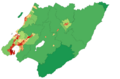
Population density at the 2006 census

See also
 In Spanish: Región de Wellington para niños
