South Wairarapa District facts for kids
Quick facts for kids
South Wairarapa District
|
||
|---|---|---|
|
Territorial authority district
|
||
 |
||
|
|
||
 |
||
| Country | New Zealand | |
| Region | Wellington | |
| Seat | Martinborough | |
| Wards | ||
| Area | ||
| • Total | 2,387.75 km2 (921.92 sq mi) | |
| Population
(June 2023)
|
||
| • Total | 11,900 | |
| • Density | 4.984/km2 (12.91/sq mi) | |
| Time zone | UTC+12 (NZST) | |
| • Summer (DST) | UTC+13 (NZDT) | |
| Postcode(s) |
5710, 5711, 5712, 5740, 5741, 5742, 5771, 5772, 5773, 5781, 5782, 5783, 5784, 5794
|
|
| Area code(s) | 06 | |
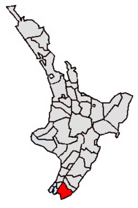
The South Wairarapa District is a special area in the south-east part of New Zealand's North Island. It is managed by the South Wairarapa District Council. This district is the southernmost part of the Wairarapa region. It is also part of the larger Wellington Region.
Contents
Exploring South Wairarapa's Geography
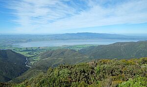
The South Wairarapa District has many interesting natural features. It includes the flat lands around the Ruamahanga River. This area is often flooded by the river, which helps create rich soil. You'll also find Lake Wairarapa here, a large lake connected to the river.
Coastal Views and Mountain Ranges
Along the coast, there is a long stretch of Palliser Bay. To the west, you can see the eastern slopes of the Remutaka Range. The top of this mountain range forms the district's western border. To the south-east, the Aorangi Range stands tall. The very tip of the North Island, called Cape Palliser, is located in the South Wairarapa District.
Main Towns in the District
Even though most of the district is countryside, there are three main towns.
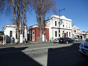
- Greytown and Featherston are the two largest towns. They have almost the same number of people living in them. Greytown is famous for being the first place in New Zealand to celebrate Arbor Day. This is a day dedicated to planting trees.
- In Featherston, you can visit the Fell Locomotive Museum. This museum shows off the world's only Fell locomotive. This is a special type of train engine.
- Martinborough is the third-largest town. It is also where the district council has its main office. Martinborough is well-known for its vineyards and is an important area for making wine in New Zealand.
More people are expected to move to these towns. This is because house prices in Wellington are rising. South Wairarapa is also close to good transport links.
Who Lives in South Wairarapa?
The South Wairarapa District covers about 2,387.75 square kilometres. In 2023, about 11,811 people lived here. This means there are about 4.9 people for every square kilometre.
Population Changes Over Time
The number of people living in South Wairarapa has been growing.
- In 2006, there were 8,892 people.
- By 2013, the population grew to 9,528.
- In 2018, it reached 10,575.
- By 2023, the population was 11,811. This was a jump of 1,236 people since 2018.
Age and Background of Residents
The average age of people in South Wairarapa in 2023 was 47.5 years. This is a bit older than the national average of 38.1 years.
- About 17.2% of the people were under 15 years old.
- About 12.3% were aged 15 to 29.
- About 47.2% were aged 30 to 64.
- About 23.1% were 65 years or older.
Most people in the district are of European or Pākehā background, about 90.1%. Other groups include:
- Māori: 15.4%
- Pasifika: 2.7%
- Asian: 3.5%
- Middle Eastern, Latin American, and African New Zealanders: 0.7%
- Other backgrounds: 1.2%
Some people identify with more than one ethnic group.
Work and Education
In 2018, about 17.2% of people were born outside New Zealand. This is less than the national average of 27.1%.
When it comes to religion, many people (55.6%) said they had no religion. About 33.4% were Christian. Smaller numbers followed Māori religious beliefs, Hinduism, Islam, or Buddhism.
Many adults in South Wairarapa have good qualifications. About 23.9% of people aged 15 or older had a university degree or higher. The average income was $32,900. About 49.0% of people aged 15 or older worked full-time.
Getting Around South Wairarapa
South Wairarapa is quite close to Wellington, New Zealand's capital city. This means there are strong connections between the two areas. For example, some people live in South Wairarapa and travel to Wellington for work every day. Others live and work in Wellington but spend their weekends enjoying South Wairarapa.
Train and Bus Services
The Wairarapa Line train passes through the district. This train line is part of the Metlink public transport system for the Wellington region. There are two train stations in the district: Featherston and Woodside. Taking the train is a faster way to get into Wellington than driving over the Remutaka pass road. Metlink buses also run services to Greytown and Martinborough. These buses connect with the train stations and the town of Masterton.
 | Leon Lynch |
 | Milton P. Webster |
 | Ferdinand Smith |


