
Martinborough facts for kids
Quick facts for kids
Martinborough
Wharekaka (Māori)
|
|
|---|---|

Martinborough's Memorial Square
|
|
| Region | Wellington Region |
| Territorial authority | South Wairarapa District |
| Ward | Martinborough Ward |
| Community | Martinborough Community |
| Electorates |
|
| Area | |
| • Total | 4.86 km2 (1.88 sq mi) |
| Population
(June 2023)
|
|
| • Total | 2,060 |
| • Density | 423.9/km2 (1,098/sq mi) |
| Time zone | UTC+12 (NZST) |
| • Summer (DST) | UTC+13 (NZDT) |
| Postcode(s) |
5711
|
| Area code(s) | 06 |

Martinborough is a lovely town in the South Wairarapa District of New Zealand's Wellington Region. Its Māori names are Wharekaka or Huangarua. The town is about 65 kilometres east of Wellington and 35 kilometres south-west of Masterton. Around 2,060 (June 2023). people live here. Martinborough is also where the South Wairarapa District Council has its main office.
Contents
History and Culture of Martinborough
How Martinborough Started
John Martin is known as the founder of Martinborough. In the 1800s, he planned the town's streets in a special pattern that looks like the Union Flag. Before Martinborough was built, this area was called Waihenga. One cool thing about the town is its old buildings, like the historic Martinborough Hotel, which was built way back in 1882. For a long time, Martinborough was mainly a small town that helped out the nearby farms. Later, growing grapes for wine became a big part of its economy.
Past Mayors of Martinborough
From 1928 to 1989, Martinborough had its own mayor and town council. This council was called the Martinborough Borough Council. In 1989, Martinborough joined with other nearby towns like Greytown and Featherston. They all became part of the larger South Wairarapa District Council. This change was part of a big government reform in New Zealand.
Here are the people who served as mayor of Martinborough:
| Number | Name | Years in Office |
|---|---|---|
| 1 | W.B. Martin | 1928-1938 |
| 2 | C.W.F. Skill | 1938-1941 |
| 3 | C.R. Holmes | 1941-1946 |
| 4 | J. Martin | 1946–1953 |
| 5 | L.A. Campbell | 1953–1965 |
| 6 | S.H. Ussher | 1965-1973 |
| 7 | Dawson Wright | 1973–1989 |
Local Māori Culture
Martinborough is home to the Hau Ariki Marae and Te Whare Wananga o Tupai meeting house. These important places are connected to the Ngāti Kahungunu hapū (sub-tribe) called Ngāti Hikawera o Kahungunu. A marae is a special meeting ground for Māori people. In 2020, the New Zealand government helped fund upgrades to the marae. This project also created 37 jobs for people in the area.
Population of Martinborough
Martinborough covers an area of about 4.86 square kilometres. As of June 2023, the estimated population is 2,060. This means there are about 424 people living in each square kilometre.
The town's population has been growing. In 2018, there were 1,767 people living in Martinborough. This was a good increase from 1,473 people in 2013 and 1,329 people in 2006. The average age in Martinborough in 2018 was 49.3 years. About 16% of the people were under 15 years old.
Most people in Martinborough identify as European/Pākehā (84.9%). There is also a significant Māori population (18.5%). Other groups include Pasifika, Asian, and other ethnicities. Many people in New Zealand identify with more than one ethnic group. About 19.5% of Martinborough's residents were born overseas.
When it comes to beliefs, 57% of people said they had no religion in 2018. About 31% were Christian. Other religions included Māori religious beliefs, Hindu, Muslim, and Buddhist.
Martinborough's Economy
.jpg)
.jpg)
.jpg)
Martinborough is famous for its many vineyards. These vineyards grow grapes to make delicious wines, especially Pinot noir. Martinborough has a special climate that is warm and sunny. This is because hills to the east and west protect the town. Most of the vineyards are found along old riverbeds. These areas have the perfect soil for growing grapes.
Some well-known wineries here include Schubert Wines, Te Kairanga, and Ata Rangi. Every November, the town celebrates its wines with the Toast Martinborough wine festival. This event is very popular and brings about 10,000 visitors to the town!
Besides wine, other important industries in Martinborough include traditional beef and sheep farming. People also grow olives, lavender, and nuts. Fishing is important in nearby coastal towns like Ngawi and Cape Palliser. Tourism is a big part of Martinborough's economy. The local i-site (information centre) helps visitors find places to stay, fun activities, wineries, and restaurants. You can also take tours of the vineyards. Martinborough even has its own brewery.
Wairarapa Dark Sky Reserve
Imagine a place where the night sky is incredibly clear and full of stars! In January 2023, a huge area of 3,665 square kilometres was named the Wairarapa Dark Sky Reserve. This means it's a special place protected from light pollution. It's only the second dark sky reserve in New Zealand.
Getting this special status took five years of hard work by volunteers. The reserve includes the Aorangi Forest Park and parts of the South Wairarapa and Carterton Districts. Martinborough is right in the middle of this amazing dark sky area. The first public meeting to talk about creating this reserve was held in Martinborough.
Education in Martinborough
Martinborough School is a primary school for students from Year 1 to Year 8. It teaches both boys and girls. As of February 2024, the school has a roll of 229 students.
For high school, students usually go to Kuranui College, which is the closest option. There was a plan for a cooking school, Le Cordon Bleu, to open a campus in Martinborough. However, they decided to open in Wellington instead. Many locals were disappointed, as they hoped it would help the town's economy.
Climate
| Climate data for Martinborough (1991–2020 normals, extremes 1968–1969, 1986–present) | |||||||||||||
|---|---|---|---|---|---|---|---|---|---|---|---|---|---|
| Month | Jan | Feb | Mar | Apr | May | Jun | Jul | Aug | Sep | Oct | Nov | Dec | Year |
| Record high °C (°F) | 34.2 (93.6) |
34.1 (93.4) |
31.0 (87.8) |
27.1 (80.8) |
23.8 (74.8) |
21.1 (70.0) |
19.2 (66.6) |
20.6 (69.1) |
26.0 (78.8) |
26.2 (79.2) |
30.7 (87.3) |
31.3 (88.3) |
34.2 (93.6) |
| Mean maximum °C (°F) | 30.3 (86.5) |
29.6 (85.3) |
27.2 (81.0) |
23.5 (74.3) |
20.7 (69.3) |
17.7 (63.9) |
16.6 (61.9) |
17.9 (64.2) |
20.1 (68.2) |
22.3 (72.1) |
25.3 (77.5) |
27.8 (82.0) |
31.7 (89.1) |
| Mean daily maximum °C (°F) | 23.6 (74.5) |
23.7 (74.7) |
21.6 (70.9) |
18.5 (65.3) |
15.9 (60.6) |
13.3 (55.9) |
12.7 (54.9) |
13.7 (56.7) |
15.4 (59.7) |
17.1 (62.8) |
19.1 (66.4) |
21.5 (70.7) |
18.0 (64.4) |
| Daily mean °C (°F) | 17.9 (64.2) |
17.8 (64.0) |
15.9 (60.6) |
13.1 (55.6) |
10.9 (51.6) |
8.6 (47.5) |
8.1 (46.6) |
8.9 (48.0) |
10.6 (51.1) |
12.2 (54.0) |
13.9 (57.0) |
16.4 (61.5) |
12.9 (55.1) |
| Mean daily minimum °C (°F) | 12.2 (54.0) |
11.9 (53.4) |
10.2 (50.4) |
7.8 (46.0) |
5.9 (42.6) |
3.9 (39.0) |
3.4 (38.1) |
4.2 (39.6) |
5.9 (42.6) |
7.3 (45.1) |
8.7 (47.7) |
11.2 (52.2) |
7.7 (45.9) |
| Mean minimum °C (°F) | 4.7 (40.5) |
4.4 (39.9) |
2.9 (37.2) |
0.7 (33.3) |
−1.4 (29.5) |
−2.5 (27.5) |
−2.5 (27.5) |
−1.8 (28.8) |
−1.2 (29.8) |
−0.3 (31.5) |
1.3 (34.3) |
3.6 (38.5) |
−3.2 (26.2) |
| Record low °C (°F) | 1.2 (34.2) |
1.8 (35.2) |
0.6 (33.1) |
−2.1 (28.2) |
−3.9 (25.0) |
−4.3 (24.3) |
−4.3 (24.3) |
−4.0 (24.8) |
−3.1 (26.4) |
−1.8 (28.8) |
−1.2 (29.8) |
−1.6 (29.1) |
−4.3 (24.3) |
| Average rainfall mm (inches) | 45.2 (1.78) |
52.2 (2.06) |
50.3 (1.98) |
62.4 (2.46) |
62.7 (2.47) |
81.9 (3.22) |
86.8 (3.42) |
71.4 (2.81) |
59.9 (2.36) |
69.7 (2.74) |
66.3 (2.61) |
58.8 (2.31) |
767.6 (30.22) |
| Mean monthly sunshine hours | 234.9 | 198.1 | 194.5 | 152.0 | 127.4 | 95.4 | 104.2 | 138.7 | 168.6 | 195.2 | 222.4 | 203.1 | 2,034.5 |
| Source: NIWA | |||||||||||||
Martinborough has a generally mild climate. The warmest months are January and February, while July is usually the coolest. The area gets a moderate amount of rain throughout the year.
Famous People from Martinborough
- John Martin - He was a politician and landowner, and he founded Martinborough.
- Eric Ramsden - He was a journalist and author.
Images for kids
-
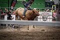
Martinborough Rodeo 2016
-
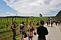
People enjoying Toast Martinborough 2011
-
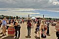
A large crowd at Toast Martinborough 2011
