
Masterton facts for kids
Quick facts for kids
Masterton
Whakaoriori (Māori)
|
|
|---|---|
|
Territorial authority district
|
|
 |
|

Masterton district within the North Island
|
|
| Country | New Zealand |
| Region | Greater Wellington |
| District | Masterton District |
| Town founded | 1854 |
| NZ Parliament | Ikaroa-Rāwhiti (Māori) Wairarapa |
| Area | |
| • Territorial | 2,300.21 km2 (888.12 sq mi) |
| • Urban | 22.45 km2 (8.67 sq mi) |
| Elevation | 69 m (420 ft) |
| Population
(June 2023)
|
|
| • Territorial | 29,100 |
| • Density | 12.651/km2 (32.77/sq mi) |
| • Urban | 22,600 |
| • Urban density | 1,006.7/km2 (2,607/sq mi) |
| Time zone | UTC+12 (NZST) |
| • Summer (DST) | UTC+13 (NZDT) |
| Postcode |
5810
|
| Area code(s) | 06 |
Masterton (Whakaoriori in Māori) is a major town in the Greater Wellington Region of New Zealand. It is the main town of the Masterton District, which is a local government area. Masterton is the largest town in the Wairarapa region. This region is separated from Wellington by the Remutaka mountain ranges.
The town is located on the Waipoua stream. It sits between the Ruamāhunga and Waingawa Rivers. Masterton is about 100 kilometres (62 miles) north-east of Wellington. It is also 40 kilometres (25 miles) south of Eketāhuna.
Masterton has an urban population of 22,600. The wider district has a population of 29,100 (June 2023).
Many businesses in Masterton support local farmers. New industrial areas are being built in Waingawa, Solway, and Upper Plain. The town is also famous for hosting the annual Golden Shears sheep-shearing competition.
Contents
Masterton's Neighbourhoods
Masterton has several different neighbourhoods, called suburbs. These include:
- Lansdowne and Te Ore Ore are on the northern side.
- Eastside and Homebush are on the eastern side.
- Upper Plain, Fernridge, Ngaumutawa, Ākura, and Masterton West are on the western side.
- Kuripuni and Solway are on the southern side.
History and Culture of Masterton
How Masterton Began
Masterton was started in 1854 by a group called the Small Farms Association. Joseph Masters led this group, and the town was named after him. Their goal was to help working people settle in villages and on the land.
At first, Masterton grew slowly. But as farming in the area became more successful, the town began to thrive. In the 1870s, Masterton became the main town in the Wairarapa region. It became a borough (a type of town council) in 1877. The railway line from Wellington reached Masterton in 1880. This railway helped Masterton become the main market and distribution centre for the Wairarapa.
A timber mill in Waipoua was making butter boxes as early as 1884. In April 1965, a serious industrial accident happened at a factory on Dixon Street. During World War II, two groups of United States Marine Corps soldiers were based in Masterton.
-
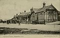
The railway station opened in 1880.
-
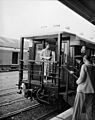
Queen Elizabeth II at the railway station in 1954.
-
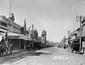
Queen Street in the early 1900s.
-
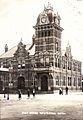
The Post Office opened in 1900.
-
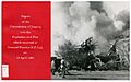
The General Plastics factory after an accident in 1965.
.jpg)
.jpg)
_(cropped).jpg)
.jpg)
_Ltd._Explosion_and_Fire_(1965)_(26271497746).jpg)
Masterton's Recent History
Masterton's growth slowed down after 1974. This was when Britain joined the European Union, which affected New Zealand's farming exports. Efforts were made to bring new industries to Masterton, but the town's economy still faced challenges.
From the 1970s onwards, some people and businesses moved away. In the 1980s, more businesses closed due to government changes. This caused the town to decline further. By 1989, Masterton did not meet the new population requirement to be called a city.
Māori Culture and Marae
Masterton is home to important marae (meeting grounds) for Māori people. Te Oreore marae and its meeting house, Ngā Tau e Waru, are located here. This marae is connected to the iwi (tribes) of Ngāti Kahungunu and Rangitāne.
In 2020, the government provided funding to improve Te Oreore marae and several other marae in the area. These projects helped create jobs. Another local marae is Ākura Marae. It is linked to the Ngāti Kahungunu and Rangitāne iwi as well.
Population and People

The Masterton District covers about 2,300 square kilometres (888 square miles). It has an estimated population of 29,100 as of June 2023, . This means there are about 13 people per square kilometre. The main urban area of Masterton is smaller, covering about 22.45 square kilometres (8.67 square miles). Its estimated population is 22,600.
| Historical population for the Masterton District | ||
|---|---|---|
| Year | Pop. | ±% p.a. |
| 1891 | 3,114 | — |
| 1896 | 3,493 | +2.32% |
| 1901 | 3,949 | +2.48% |
| 1906 | 3,723 | −1.17% |
| 1911 | 5,182 | +6.84% |
| 1916 | 5,560 | +1.42% |
| 1921 | 7,820 | +7.06% |
| 1926 | 8,575 | +1.86% |
| 1936 | 8,950 | +0.43% |
| 1945 | 9,480 | +0.64% |
| 1951 | 11,545 | +3.34% |
| 1956 | 13,000 | +2.40% |
| 1961 | 16,944 | +5.44% |
| 1966 | 19,116 | +2.44% |
| 1971 | 20,194 | +1.10% |
| 1976 | 19,460 | −0.74% |
| 1981 | 18,545 | −0.96% |
| 1986 | 20,145 | +1.67% |
| 1991 | 22,566 | +2.30% |
| 1996 | 22,755 | +0.17% |
| 2001 | 22,614 | −0.12% |
| 2006 | 22,623 | +0.01% |
| 2013 | 23,352 | +0.45% |
| 2018 | 25,557 | +1.82% |
| 2023 | 27,678 | +1.61% |

In the 2023 New Zealand census, Masterton District had 27,678 people. This was an increase of 8.3% since 2018. The median age was 42.7 years. About 18.5% of people were under 15 years old.
Most people in Masterton District are European (83.7%). About 22.6% identify as Māori. Other groups include Pasifika (4.6%) and Asian (5.1%). English is spoken by 97.4% of people. Māori language is spoken by 4.7%.
Many people in Masterton (55.5%) said they had no religion. About 32.5% identified as Christian.
Masterton Urban Area Population
Masterton's urban area had 21,606 people in the 2023 census. This was an increase of 8.5% since 2018. The median age was 41.3 years. About 18.6% of people were under 15 years old.
| Historical population for the Masterton urban area | ||
|---|---|---|
| Year | Pop. | ±% p.a. |
| 2013 | 18,246 | — |
| 2018 | 19,917 | +1.77% |
| 2023 | 21,606 | +1.64% |
In the urban area, 81.0% of people were European. About 25.1% were Māori. English was spoken by 97.2% of people. Māori language was spoken by 5.3%.
Masterton's Climate
Masterton has a mild temperate climate. This means it has warm, dry summers and colder winters. Temperatures can go above 30°C (86°F) in summer. In winter, it often freezes, with temperatures below 0°C (32°F). The mountains nearby, called the Tararua Range, cause the town's temperature to change more than other places.
| Climate data for Masterton (1991–2020 normals, extremes 1906-present) | |||||||||||||
|---|---|---|---|---|---|---|---|---|---|---|---|---|---|
| Month | Jan | Feb | Mar | Apr | May | Jun | Jul | Aug | Sep | Oct | Nov | Dec | Year |
| Record high °C (°F) | 35.6 (96.1) |
35.1 (95.2) |
34.4 (93.9) |
29.9 (85.8) |
27.3 (81.1) |
22.2 (72.0) |
21.9 (71.4) |
21.9 (71.4) |
26 (79) |
28.4 (83.1) |
31.3 (88.3) |
35.1 (95.2) |
35.6 (96.1) |
| Mean daily maximum °C (°F) | 25.3 (77.5) |
25.1 (77.2) |
22.6 (72.7) |
19.3 (66.7) |
16.3 (61.3) |
12.9 (55.2) |
12.9 (55.2) |
14.1 (57.4) |
16.0 (60.8) |
18.3 (64.9) |
20.4 (68.7) |
22.7 (72.9) |
18.8 (65.8) |
| Daily mean °C (°F) | 18.7 (65.7) |
18.5 (65.3) |
16.5 (61.7) |
13.5 (56.3) |
11.1 (52.0) |
8.5 (47.3) |
8.0 (46.4) |
9.1 (48.4) |
10.9 (51.6) |
12.7 (54.9) |
14.5 (58.1) |
16.9 (62.4) |
13.2 (55.8) |
| Mean daily minimum °C (°F) | 12.1 (53.8) |
11.8 (53.2) |
10.3 (50.5) |
7.7 (45.9) |
5.8 (42.4) |
4.1 (39.4) |
3.1 (37.6) |
4.1 (39.4) |
5.8 (42.4) |
7.1 (44.8) |
8.6 (47.5) |
11.0 (51.8) |
7.6 (45.7) |
| Record low °C (°F) | −1.1 (30.0) |
0.5 (32.9) |
−2.2 (28.0) |
−3.3 (26.1) |
−4.6 (23.7) |
−6.9 (19.6) |
−7 (19) |
−6.9 (19.6) |
−4.6 (23.7) |
−3.9 (25.0) |
−2.2 (28.0) |
−0.6 (30.9) |
−7 (19) |
| Average rainfall mm (inches) | 52.4 (2.06) |
48.5 (1.91) |
69.9 (2.75) |
71.5 (2.81) |
72.9 (2.87) |
91.0 (3.58) |
113.6 (4.47) |
81.7 (3.22) |
73.2 (2.88) |
82.0 (3.23) |
71.9 (2.83) |
60.6 (2.39) |
889.2 (35) |
| Average rainy days (≥ 1.0 mm) | 5.2 | 4.7 | 6.2 | 8.5 | 10.3 | 9.9 | 10.6 | 11.8 | 10.7 | 9.2 | 8.5 | 6.9 | 102.5 |
| Average relative humidity (%) | 76.0 | 82.9 | 84.2 | 87.0 | 89.5 | 91.3 | 91.1 | 89.6 | 83.5 | 79.0 | 78.8 | 76.9 | 84.2 |
| Mean monthly sunshine hours | 232.2 | 197.0 | 180.0 | 159.7 | 139.5 | 106.1 | 115.3 | 156.0 | 165.8 | 204.3 | 200.9 | 220.1 | 2,076.9 |
| Source: NIWA Climate Data (humidity 1981–2010) | |||||||||||||
Education in Masterton
Masterton has many schools for students of all ages. In 2003, some primary schools closed or joined together to better serve the changing population.
Today, Masterton has five state primary schools:
- Douglas Park
- Fernridge
- Masterton Primary
- Solway (these four are "contributing" primaries, meaning they go up to Year 6)
- Lakeview (a "full" primary, going up to Year 8)
In the surrounding district, there are five more state full primary schools: Mauriceville, Opaki, Tinui, Wainuiouru, and Whareama. There are also two state-integrated primary schools: St Patrick's (Catholic) and Hadlow (Anglican).
Masterton Intermediate School is the only intermediate school in Masterton. It has over 500 students and helps students transition from primary to secondary school.
For secondary education, Masterton has two state high schools:
- Wairarapa College: The largest, with 1050 students, serving the western side of town.
- Makoura College: With 320 students, serving the eastern side of town.
There are also four state-integrated schools:
- Chanel College: A co-educational Catholic school with an intermediate section.
- Rathkeale College: An Anglican school for boys.
- St Matthew's Collegiate: An Anglican school for girls, also with an intermediate section.
- Solway College: A Presbyterian school for girls, also with an intermediate section.
Additionally, there is Te Kura Kaupapa Māori o Wairarapa. This is a Māori immersion school that combines primary and secondary levels.
Masterton also has its own polytechnic, UCOL (Universal College of Learning). This offers higher education courses. The Masterton District Library and Archive is on Queen Street. It is part of a group of 22 libraries that share books and information.
Media in Masterton
Newspapers

Several newspapers are available in Masterton. These include two daily papers and a free community paper. The Wairarapa Times-Age is the only daily newspaper based in Masterton. It was formed in 1938 by combining two older papers. The Wairarapa Times-Age is now owned by Stuff Group.
The Wairarapa Midweek is a free weekly community paper. It is given out every Wednesday. The Wairarapa Times-Age building no longer prints newspapers.
The Post, a daily newspaper from Wellington, is also widely read in Masterton.
Radio
Masterton has one local radio station, MORE FM 89.5 or 105.9 for the coast. MORE FM broadcasts locally from its studios in Kuripuni. The station started in 1991 as TODAY FM 89.3.
Television
Television came to Masterton in 1963. A transmitter east of town, called Otahoua, helped relay the TV signal. Digital television (Freeview HD) became available in Masterton in 2011. This was in preparation for the switch to digital TV in 2013.
Utilities and Services
Water and Drainage
Masterton gets its water from the Waingawa River. The water goes through a treatment plant about 10 kilometres (6 miles) west of town. Here, it is cleaned, filtered, and treated to make it safe to drink. There is also a special tap in Manuka Reserve for water without fluoride.
In the past, Masterton had problems with water supply. In 1896, a plan was approved to build a better water and drainage system. The new water system was finished in 1900. The current water system was completed in 1983.
A sewage system was built in 1901. It sent treated wastewater into the Ruamahanga River. In 2013, when a new treatment pond was being built, about 85,000 eels living in the old pond had to be moved. The iwi Ngati Kahungunu helped move about half of these eels to other lakes and streams. Sometimes, heavy rain can cause sewage overflows into the river or properties.
Energy
The Wairarapa Electric Power Board was created in 1920 to provide electricity to the Wairarapa. Masterton was connected to the main power grid in 1925. Today, Powerco operates the local electricity network.
Masterton used to have a gas company, which started in 1886. It made gas from coal. However, people started preferring electricity, and the gasworks closed in the 1950s. Masterton does not have a natural gas network.
Telephone and Internet
Masterton's first telephone exchange opened in 1897 with 53 users. In 1919, Masterton became the first town in New Zealand to have a fully automatic telephone exchange. Masterton and nearby Carterton were also the first towns in New Zealand to use the emergency number 111, starting in 1958.
Today, the area code for Masterton is 06. In 2015, the UFB (fast internet) network was completed in the town.
Getting Around Masterton
Masterton has good public transport options, including trains and buses. Even though Masterton is close to Wellington, the Rimutaka Range mountains separate them. State Highway 2 goes over the mountains, and the Rimutaka railway tunnel goes through them. The Wairarapa Line railway connects Masterton to Wellington, Lower Hutt, and Upper Hutt.
Passenger train services have continued in the Wairarapa because of the tunnel. There have been talks about building a road tunnel through the mountains, but it would be very expensive. Plans now focus on improving the existing Rimutaka Hill road.
Train Travel
Masterton is connected to Wellington and the Hutt Valley by the Wairarapa Connection train service. This service is mainly for people who travel to work. There are five return services on weekdays and two on weekends. Masterton has three railway stations: Masterton, Renall Street, and Solway. A new rail freight hub opened in 2016 to help with logging transport.
Bus Travel

Masterton has a local bus service operated by Tranzit under the Metlink brand. The buses run on five routes:
| Metlink Bus Services | Where it goes |
|---|---|
| Route 200 Masterton/Featherston |
Wairarapa Hospital Featherston Station |
| Route 201 Masterton West |
Masterton – Church Street Worksop Road (Woolworths) |
| Route 202 Masterton South & East |
Masterton – Church Street Masterton – Church Street |
| Route 203 Masterton – Lansdowne Circuit |
Masterton – Church Street Worksop Road (Woolworths) |
| Route 205 Featherston/Martinborough |
Featherston Station Martinborough |
There is also a bus service from Masterton to Palmerston North.
Air Travel
Hood Aerodrome is an airport located southwest of Masterton. As of 2015, there are no regular commercial flights from Hood Aerodrome. In the past, some airlines tried to offer flights, but they often stopped because Masterton is close to bigger airports in Wellington and Palmerston North.
Queen Elizabeth Park
.jpg)
Queen Elizabeth Park is a large park covering over 20 hectares (50 acres). It is located near the centre of Masterton. The land for the park was set aside in 1854. The park is known for its huge Giant Sequoia trees, planted in 1875, and its other old trees. It also has a sheltered cricket ground.
Queen Elizabeth II visited the park in 1954. She was welcomed by many people and schoolchildren. After her visit, the park was named after her.
Miniature Railway

The park has a miniature railway. It was built by the Jaycees group and opened in 1972. The train ride costs $1, which has been the same price since 1984. The railway has a steam locomotive that was restored in 2021.
Museum
The Aratoi Wairarapa Museum of Art and History opened in Masterton in 1969. It started with a sculpture by Barbara Hepworth. Now, the museum has almost 4,000 items in its collection.
Sports in Masterton
Masterton is home to several sports teams and facilities.
- In rugby union, the Heartland Championship team Wairarapa Bush plays its home games at Memorial Park.
- In association football (soccer), the Central Premier League team Wairarapa United plays some of its home games in Masterton.
- In cricket, the Hawke Cup team Wairarapa is based in Masterton. Their home ground is Queen Elizabeth Park.
- Masterton has an all-weather athletics track at the Colin Pugh Sports Bowl in Lansdowne.
- A motorcycle speedway track called Penlee Speedway was active in the 1970s and 1980s. It hosted important speedway events.
Famous People from Masterton
- Sylvia Ashton-Warner, writer
- Barry Barclay, writer and filmmaker
- Amanda Billing, actor
- Michael Bracewell, international cricketer
- Jemaine Clement, actor, comedian and musician
- Ian Cross, novelist
- Haddon Donald, soldier and politician
- Pat Evison, actor
- Bill Francis, broadcaster
- Raybon Kan, writer and comedian
- Ladyhawke, singer-songwriter
- Sir Brian Lochore, All Black rugby player
- Alan MacDiarmid, Nobel Prize winning chemist
- Ron Mark, soldier and politician
- Jesse Ryder, cricketer
- Brad Shields, rugby player
- Aaron Slight, motorcycle racer
- Selina Sutherland, nurse and founder of Masterton Hospital
Sister Cities
Masterton has special relationships with other cities around the world. These are called sister-city relationships:
 Hatsukaichi, Hiroshima, Japan
 Changchun, China
 Armidale, New South Wales, Australia
See also
 In Spanish: Masterton para niños
