Upper Hutt facts for kids
Quick facts for kids
Upper Hutt
Te Awa Kairangi ki Uta (Māori)
|
||
|---|---|---|
|
City
|
||
| Upper Hutt City | ||
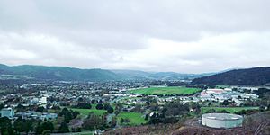
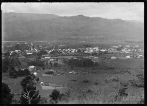
Upper Hutt, view towards city centre.
|
||
|
||
| Motto(s):
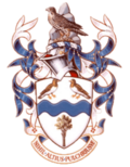
Nihil altius pulchriusue (Nothing higher nor more beautiful)
|
||
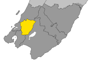
The location of Upper Hutt City within Wellington Region
|
||
| Country | New Zealand | |
| Region | Wellington | |
| Territorial Authority | Upper Hutt City | |
| City status | 1966 | |
| Borough status | 1926 | |
| Town Board | 1908 | |
| Electorates | Remutaka (general) Mana (general) Ikaroa-Rāwhiti (Māori) Te Tai Hauāuru (Māori) |
|
| Suburbs |
List
|
|
| Government | ||
| • Type | City Council | |
| Area | ||
| • Territorial | 539.88 km2 (208.45 sq mi) | |
| • Urban | 51.16 km2 (19.75 sq mi) | |
| • Rural | 488.72 km2 (188.70 sq mi) | |
| Population
(June 2023)
|
||
| • Territorial | 48,300 | |
| • Density | 89.46/km2 (231.71/sq mi) | |
| • Urban | 45,400 | |
| • Urban density | 887.4/km2 (2,298.4/sq mi) | |
| Time zone | UTC+12 (NZST) | |
| • Summer (DST) | UTC+13 (NZDT) | |
| Postcode |
5018, 5019
|
|
| Area code(s) | 04 | |
Upper Hutt (which in Māori is called Te Awa Kairangi ki Uta) is a city in the Wellington Region of New Zealand. It is one of the four main cities that make up the Wellington metropolitan area.
Contents
History of Upper Hutt
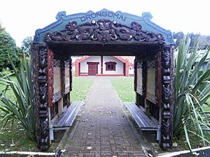
Upper Hutt is located in an area that was originally known as Orongomai. The river in this area was called Heretaunga, which is now the name of a suburb in Upper Hutt. The very first people to live here were Māori from the Ngāi Tara iwi (tribe). Over the years, other iwi also lived in and controlled the area. By 1840, when the first European settlers arrived, the area was part of the Te Āti Awa rohe (territory).
Orongomai Marae, an important Māori meeting place, is located south of the city centre today.
Early European Settlement
In 1839, a British company called The New Zealand Company bought a large area of land in the Wellington region, including Upper Hutt, from Māori chiefs. The Hutt Valley is named after one of the founders of this company. However, these land deals were not always fair, as they didn't involve all the Māori iwi who had claims to the land. This led to disagreements and fighting in the Hutt Valley in 1846. Troops led by Governor George Grey fought against Māori chiefs like Te Rauparaha and Te Rangihaeata, and iwi such as Ngāti Toa.
Richard Barton was the first European to settle in Upper Hutt in 1841. He lived in the area now known as Trentham Memorial Park. Barton later divided his land and set aside a large part of it to become a park. Another early settler, James Brown, arrived in 1848 in the area that became the town of Upper Hutt.
The settlers divided the land into blocks and began clearing the native forest to create farmland. They cut down large trees like Totara for building materials and burned the remaining bushes.
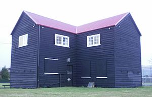
In 1860, settlers in the Hutt Valley worried about unrest in other parts of New Zealand and asked for protection. The government built two forts, called stockades, in the Hutt Valley. The one in Upper Hutt was used for six months, but luckily, there was no fighting there.
Growth and Development
The railway line from Wellington reached Upper Hutt on February 1, 1876. This made it easier for people and goods to travel. The line was later extended further north to Kaitoke and then over the Remutaka Ranges to Featherston in the Wairarapa region. This part of the railway used special Fell engines to climb the steep hills.
By 1914, Upper Hutt had its own water supply. This was improved in 1930 with the building of the Birchville Dam.
For many years, Upper Hutt was a small town that supported local farms and forests. But from the late 1940s, its population grew very quickly. Many people moved from busy Wellington to the quieter Hutt Valley. In 1950, Trentham Memorial Park, a large park of almost 50 hectares, was created.
Upper Hutt continued to grow and officially became a city on May 2, 1966, when its population reached 20,000 people.
In 1976, Upper Hutt was the first place in New Zealand to get "subscriber toll dialling" (STD). This meant people could make national phone calls without needing an operator to connect them.
New housing areas like Clouston Park, Maoribank, Tōtara Park, and Kingsley Heights continued to be built in the 1980s. In February 1979, the famous boxer Muhammed Ali even visited Upper Hutt!
Historic Places to Visit
Upper Hutt has twelve historic sites listed by Heritage New Zealand. These include old buildings and the Remutaka Rail Trail, which is a historic railway path.
Geography and Climate
Upper Hutt city centre is about 26 kilometres northeast of Wellington. Most of the city is built along the flat valley floor of the Te Awa Kairangi / Hutt River. However, the city's area stretches far into the hills, reaching the top of the Remutaka Pass and into the Akatarawa Valley.
The city is in an old river flood plain, which means it used to flood often. In the 1970s and 1980s, a large wall called a stop bank was built along the river to prevent future floods. The main urban area of Upper Hutt spreads across this wide, flat plain.
Weather in Upper Hutt
Upper Hutt has a mild climate. Because it's in a sheltered valley, it's usually warmer than central Wellington in summer and much colder in winter. Summer temperatures can reach the mid-30s Celsius (around 95°F), and winter temperatures can drop to about -5°C (23°F), with lots of frost. Snow doesn't usually fall at sea level, but in 2011, it snowed twice, which was very exciting for residents! Upper Hutt gets about 1400 millimetres of rain each year. February is the warmest month, averaging 17.5°C, and July is the coldest, averaging 8.5°C.
| Climate data for Upper Hutt (1991–2020 normals, extremes 1939–present) | |||||||||||||
|---|---|---|---|---|---|---|---|---|---|---|---|---|---|
| Month | Jan | Feb | Mar | Apr | May | Jun | Jul | Aug | Sep | Oct | Nov | Dec | Year |
| Record high °C (°F) | 33.5 (92.3) |
31.0 (87.8) |
30.8 (87.4) |
26.0 (78.8) |
23.3 (73.9) |
20.2 (68.4) |
19.5 (67.1) |
20.5 (68.9) |
23.1 (73.6) |
25.9 (78.6) |
27.4 (81.3) |
29.3 (84.7) |
33.5 (92.3) |
| Mean daily maximum °C (°F) | 22.2 (72.0) |
22.3 (72.1) |
20.6 (69.1) |
17.8 (64.0) |
15.5 (59.9) |
12.9 (55.2) |
12.4 (54.3) |
13.0 (55.4) |
14.3 (57.7) |
16.1 (61.0) |
17.8 (64.0) |
20.1 (68.2) |
17.1 (62.7) |
| Daily mean °C (°F) | 17.1 (62.8) |
17.0 (62.6) |
15.2 (59.4) |
12.7 (54.9) |
10.8 (51.4) |
8.2 (46.8) |
7.5 (45.5) |
8.3 (46.9) |
10.0 (50.0) |
11.6 (52.9) |
13.3 (55.9) |
15.6 (60.1) |
12.3 (54.1) |
| Mean daily minimum °C (°F) | 12.1 (53.8) |
11.6 (52.9) |
9.7 (49.5) |
7.6 (45.7) |
6.1 (43.0) |
3.5 (38.3) |
2.7 (36.9) |
3.6 (38.5) |
5.7 (42.3) |
7.2 (45.0) |
8.7 (47.7) |
11.0 (51.8) |
7.5 (45.4) |
| Record low °C (°F) | 0.6 (33.1) |
0.9 (33.6) |
−1.5 (29.3) |
−3.1 (26.4) |
−4.9 (23.2) |
−7.2 (19.0) |
−6.1 (21.0) |
−6.7 (19.9) |
−5.5 (22.1) |
−4.6 (23.7) |
−1.5 (29.3) |
−0.3 (31.5) |
−7.2 (19.0) |
| Average rainfall mm (inches) | 50.9 (2.00) |
71.0 (2.80) |
69.4 (2.73) |
106.6 (4.20) |
133.9 (5.27) |
121.5 (4.78) |
131.5 (5.18) |
110.5 (4.35) |
124.3 (4.89) |
101.1 (3.98) |
132.0 (5.20) |
103.2 (4.06) |
1,255.9 (49.44) |
| Source: NIWA | |||||||||||||
People of Upper Hutt
Upper Hutt City covers about 539.88 square kilometres. In the 2023 New Zealand census, its population was 45,759 people. This was an increase of 4.0% since the 2018 census.
The median age in Upper Hutt was 39.1 years. About 19.3% of the people were under 15 years old.
People in Upper Hutt come from many different backgrounds:
- 78.4% identified as European (Pākehā).
- 16.7% identified as Māori.
- 6.5% identified as Pasifika.
- 11.9% identified as Asian.
- 1.4% identified as Middle Eastern, Latin American, and African New Zealanders (MELAA).
- 2.7% identified with other ethnicities.
English is spoken by most people (96.6%). Other languages spoken include Māori (3.4%) and Samoan (1.7%). About 23.3% of the people in Upper Hutt were born overseas.
When it comes to religion, 33.3% of people identified as Christian, while 52.2% said they had no religion.
Many people in Upper Hutt have good qualifications. About 18.4% of people aged 15 or older have a university degree or higher. The average income was $48,600. Most people (55.5%) work full-time.
Upper Hutt Suburbs
Upper Hutt has many suburbs. Some of the main ones, from north-east to south-west, include:
- Te Mārua
- Akatarawa
- Rimutaka
- Parkdale
- Emerald Hill
- Birchville
- Timberlea
- Brown Owl
- Kaitoke
- Maoribank
- Ebdentown
- Upper Hutt Central
- Clouston Park
- Mangaroa
- Maymorn
- Whitemans Valley
- Tōtara Park
- Kingsley Heights
- Elderslea
- Wallaceville
- Trentham
- Heretaunga
- Silverstream
- Pinehaven
New housing developments in the area include Mount Timbale Marua, Marua Downs, Waitoka Estate, Wallaceville Estate, and Riverstone Terraces.
Economy and Business
Upper Hutt has seen changes in its industries over the years.
Tyre Factory History
In 1945, the company Dunlop was allowed to make tyres in New Zealand. They built a factory in Upper Hutt, and the first Dunlop tyres were made there on March 11, 1949. Later, the factory became part of South Pacific Tyres. In 2008, the factory closed down.
Brewtown Entertainment Hub
In 2008, a property developer bought the old tyre factory site. This area has now become "Brewtown," a popular place focused on craft brewing and entertainment. As of 2024, Brewtown has fun attractions like Daytona Adventure Park, where you can go Go-kart racing, ice skating, and ten-pin bowling. There are also escape rooms and axe throwing. On weekends, markets and events are held there too.
Getting Around Upper Hutt
Upper Hutt has good transport links for both roads and trains.
Roads
State Highway 2 is the main road through Upper Hutt. It connects the city to Lower Hutt and Wellington to the south, and to the Wairarapa region over the Remutaka Hill Road to the north.
Fergusson Drive is another important road that goes through the city centre.
In the 1980s, traffic in Upper Hutt became very busy. To help with this, the Upper Hutt City Council built a new, faster road called River Road along the Te Awa Kairangi / Hutt River. This road opened in 1987 and has been improved since then to handle more traffic.
State Highway 58 also connects Upper Hutt to Porirua.
Buses
Buses in Upper Hutt are run by Metlink and are planned by the Greater Wellington Regional Council. Most bus routes run from Monday to Saturday, with a special route (110) between Upper Hutt and Lower Hutt running seven days a week. All the main parts of the city have bus services.
Trains
Upper Hutt is on the Hutt Valley Line. Electric trains run regularly between Upper Hutt and Wellington. The journey to Wellington takes about 45 minutes, or around 38 minutes on express trains during busy times.
The railway line continues beyond Upper Hutt to Masterton. This part of the line is not electric. A special feature of this railway is the Rimutaka Tunnel, which is the second-longest railway tunnel in New Zealand. It opened in 1955 and made the journey much faster.
There are six train stations in Upper Hutt:
- Silverstream
- Heretaunga
- Trentham
- Wallaceville
- Upper Hutt (the main station)
- Maymorn (a stop on the Wairarapa Line)
The main Upper Hutt railway station has been rebuilt twice, most recently in 2015. The new station has a coffee shop, public toilets, and a bigger waiting room.
In 1955, the train line to Upper Hutt became electric, allowing faster trains. Also, the 8.8-kilometre Rimutaka Tunnel opened, which replaced a very steep section of track called the Remutaka Incline. This cut the travel time between Upper Hutt and Featherston from 2.5 hours to just 40 minutes.
Soon, KiwiRail's national train control centre will move to the Blue Mountains Campus in Wallaceville, Upper Hutt. This centre will manage all the trains in New Zealand.
The Old Remutaka Incline
The Rimutaka Incline was a very steep part of the railway line that used special Fell engines to pull trains up the hill. Ordinary steam trains could manage the less steep parts.
By the 1950s, this system was too expensive to run, so it closed in 1955. The Rimutaka Tunnel was built to replace it. Today, you can walk or bike along the old railway path, which is now part of the Remutaka Rail Trail.
Sports and Fun Activities
Upper Hutt is a great place for sports and outdoor activities.
- Walking and mountain biking are popular along the Te Awa Kairangi / Hutt River and on tracks in parks like Karapoti, Kaitoke, Cannon Point Walkway, Tunnel Gully, and the Remutaka Rail Trail.
- Popular team sports include Cricket, Netball, Rugby, Rugby league, Soccer, and American football.
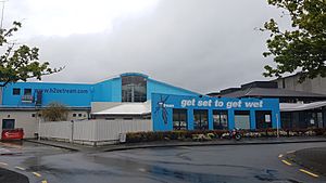
The Expressions Whirinaki Arts and Entertainment Centre is where you'll find Upper Hutt's public art gallery, which shows local and national art. The centre also has the Gillies Group Theatre for performances and the Professionals Recreation Hall for events. Nearby are the Upper Hutt Libraries and the H
2O Xtreme swimming pool.
Upper Hutt is home to one of New Zealand's biggest junior football (soccer) clubs, Upper Hutt City Soccer Club. They play their games at Maidstone Park and other local parks.
The city also has a large Inline speed skating club called Valley Inline, which holds an annual event called the Speed King Tour.
Here are some other popular places for fun:
- Staglands Wildlife Reserve at Akatarawa
- Taekwon-Do with United ITF New Zealand at Heretaunga
- Royal Wellington Golf Club at Heretaunga
- Te Mārua Golf Club at Te Mārua
- Wellington Family Speedway at Te Mārua
- Kartsport Wellington Raceway at Kaitoke
- Wellington Racing Club at Trentham
- Trentham Memorial Park at Trentham
- Cannon Point Walkway
- Birchville Dam
- Upper Hutt Rugby Football Club at Maidstone Park, Upper Hutt
- Rimutaka Rugby Football Club at Maoribank, Upper Hutt
- Upper Hutt United Cricket Club at Trentham, Upper Hutt
- Upper Hutt City Soccer Club at Maidstone Park, Upper Hutt
- Harcourt Park diskgolf course at Harcourt Park, Upper Hutt
- Upper Hutt Roller Skating Club at Upper Hutt
- Wellington Model Aeroplane Club Inc at Trentham, Upper Hutt
- Upper Hutt Hockey Club at Maidstone Park, Upper Hutt
Schools in Upper Hutt
Upper Hutt has many schools for different age groups.
Primary Schools
- Fraser Crescent School
- St Brendans School, Heretaunga
- Trentham School
- Birchville School
- Tōtara Park School
- St Josephs School, City Centre
- Upper Hutt School
- Plateau School
- Silverstream School
- Mangaroa School
- Maoribank School
- Pinehaven School
- Plateau School
- Oxford Crescent School
- Brown Owl Primary School
Intermediate Schools
- Maidstone Intermediate
- Fergusson Intermediate
Secondary Schools
- Heretaunga College
- Hutt International Boys' School, Trentham
- St. Patrick's College, Silverstream
- Upper Hutt College
Sister Cities
Upper Hutt has a special friendship with one city in the United States:
- Mesa, Arizona, United States
See also
 In Spanish: Upper Hutt para niños
 | Roy Wilkins |
 | John Lewis |
 | Linda Carol Brown |


