
Maymorn railway station facts for kids
Quick facts for kids
Maymorn
|
|||||||||||
|---|---|---|---|---|---|---|---|---|---|---|---|
| Metlink regional rail | |||||||||||

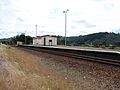
Old Maymorn railway station main platform, looking west (2007)
|
|||||||||||
| Location | Parkes Line Road, Maymorn, Upper Hutt, New Zealand | ||||||||||
| Coordinates | 41°6′29″S 175°8′3″E / 41.10806°S 175.13417°E | ||||||||||
| Elevation | 137 metres (449 ft) | ||||||||||
| Owned by | Greater Wellington Regional Council | ||||||||||
| Line(s) | Wairarapa Line | ||||||||||
| Distance | 38.75 kilometres (24.08 mi) from Wellington | ||||||||||
| Platforms | Dual side platforms | ||||||||||
| Tracks | Main line (1) | ||||||||||
| Train operators | Transdev Wellington | ||||||||||
| Construction | |||||||||||
| Parking | Yes (behind main platform, access from Maymorn Road) | ||||||||||
| Bicycle facilities | No | ||||||||||
| Other information | |||||||||||
| Station code | MAYM | ||||||||||
| Fare zone | 8 | ||||||||||
| History | |||||||||||
| Opened | 3 November 1955 | ||||||||||
| Closed |
|
||||||||||
| Previous names | Mangaroa | ||||||||||
| Services | |||||||||||
|
|||||||||||
Maymorn railway station is a train station with two platforms. It serves the small area of Maymorn near Upper Hutt in New Zealand. This station is a request stop, meaning the train only stops if someone wants to get on or off.
The station is part of the Wairarapa Connection train line. On weekdays, there are five trains each way from Monday to Thursday, and six on Friday. On weekends, there are two trains each way on Saturday and Sunday.
This station was first called Mangaroa. It got its current name, Maymorn, on January 26, 1959.
History of Maymorn Station
Maymorn station officially opened on November 3, 1955. It opened at the same time as the new Rimutaka Deviation and the Remutaka Tunnel. The old Mangaroa railway station closed when Maymorn opened.
The land where the station sits was made using dirt and rocks. This material came from digging the Rimutaka Tunnel. During the tunnel's construction, a special track loop was built. It was long enough for 116 train wagons. A temporary connection to the old railway line was also made. This allowed work trains to bring in building materials.
The connection to the old line was removed later. However, the loop track stayed in use for many years. Trains heading north used the loop and the second platform. Trains heading south used the main track and the first platform. Both platforms had wooden shelters for passengers. In 1990, part of the loop was removed. By August 1999, the entire loop was gone.
In 2007, the station was updated. This was part of a program to improve Wairarapa stations. The upgrades helped the stations work better with the new SW-class train carriages. These carriages are used for the Wairarapa Connection. At Maymorn, a system called selective door opening is used. This means only some doors open because the platform is only long enough for three train carriages.
On July 17, 2008, the station's wooden passenger shelter was badly damaged by fire. It was thought to be arson. The damage was too great to fix, so the building was pulled down the next week. A new glass shelter was put in its place on May 18, 2009.
Maymorn Station Today

Today, there are no signs of the old loop track or other side tracks. But you can still see where they used to be. For example, the second platform is still there, and there's a space between it and the main track. The Maymorn Road overpass is also extra wide.
The main platform has a passenger shelter. There are also a few small buildings for equipment. In 2009, the Rimutaka Incline Railway group dug up the back of the second platform. They did this to get dirt and to prepare for their own rail yard.
Near the station, you can see a raised area of land. This is where the old railway line used to run. Hikers can get to the old railway path from an access road. This road starts near the station, at the corner of Maymorn Road and Parkes Line Road.
Future Plans for Maymorn
On July 14, 2005, the Rimutaka Incline Railway Heritage Trust got a 20-year lease for land at the Maymorn railway yards. The trust plans to rebuild the famous Rimutaka Incline. Their main base will be at Maymorn. They are currently working on the first part of their project. This includes getting the yard ready, building new structures, putting up fences, and laying tracks.
The trust also plans to build a new railway connection. It will be about 1.6 kilometres (0.99 mi) long. This new line will connect the station to the original railway path. They prefer to lay their own track over the Maymorn Road overpass, next to the current main line.
In 2003, the Greater Wellington Regional Council suggested some changes. They proposed adding a second track from Trentham to Upper Hutt. They also suggested extending the electric train line north of Upper Hutt to Timberlea and Cruickshank Road. A plan from 2011 by the Upper Hutt City Council also suggests extending the electric line to Maymorn. This would help with the expected growth in the area.
As part of the New Zealand Upgrade Programme, announced in 2020, a new passing loop will be built at Maymorn. This will help trains pass each other more easily.
Images for kids
-
Old Maymorn railway station main platform, looking west (2007)
-
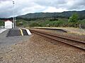
Maymorn railway station main platform (left) and disused second platform (right), looking east.
