
Mesa, Arizona facts for kids
Quick facts for kids
Mesa, Arizona
|
|||
|---|---|---|---|

Mesa Arts Center building in downtown Mesa
|
|||
|
|||

Location of Mesa in Maricopa County, Arizona
|
|||

Mesa, Arizona
Location in Arizona

Mesa, Arizona
Location in the United States
|
|||
| Country | United States | ||
| State | Arizona | ||
| County | Maricopa | ||
| Founded | 1878 | ||
| Government | |||
| • Type | Mayor–council | ||
| Area | |||
| • Total | 139.42 sq mi (361.09 km2) | ||
| • Land | 138.79 sq mi (359.48 km2) | ||
| • Water | 0.62 sq mi (1.62 km2) | ||
| Elevation | 1,326 ft (404 m) | ||
| Population
(2020)
|
|||
| • Total | 504,258 | ||
| • Estimate
(2021)
|
509,475 | ||
| • Rank | 36th in the United States 3rd in Arizona |
||
| • Density | 3,633.14/sq mi (1,402.76/km2) | ||
| Time zone | UTC−7 (MST (no DST)) | ||
| ZIP codes |
85201-85216, 85274-85275, 85277
|
||
| Area code(s) | 480 602 | ||
| FIPS code | 04-46000 | ||
| GNIS feature ID | 2411087 | ||

Mesa (/ˈmeɪsə/ MAY-sə) is a large city in Maricopa County, Arizona, United States. In 2020, about 504,258 people lived there. This makes Mesa the third-largest city in Arizona, after Phoenix and Tucson. It is also one of the biggest cities in the U.S. that is not a county seat. Mesa is part of the Phoenix metropolitan area, often called the "East Valley." It shares borders with cities like Tempe, Chandler, and Gilbert.
Mesa is home to many colleges and universities. It also has the Mesa Arizona Temple, which is one of the first temples built by The Church of Jesus Christ of Latter-day Saints outside of Utah. The city has a major airport, Phoenix–Mesa Gateway Airport, which helps with air travel in the Phoenix area.
Contents
- Mesa's History: From Ancient Canals to a Modern City
- Mesa's Geography and Climate
- Who Lives in Mesa? A Look at the Population
- Mesa's Economy: Major Employers and Industries
- Fun Things to Do: Cultural Attractions and Parks
- Learning in Mesa: Schools and Colleges
- Getting Around: Transportation in Mesa
- Notable People from Mesa
- Sister Cities
- Images for kids
- See also
Mesa's History: From Ancient Canals to a Modern City
The story of Mesa began over 2,000 years ago with the Hohokam people. This ancient group built an amazing system of canals. These canals were the largest and most advanced in the ancient New World. Some were as wide as 90 feet (27 meters) and 10 feet (3 meters) deep. They stretched for up to 16 miles (26 kilometers) across the desert.
By the year 1100 AD, these canals could water over 110,000 acres (445 square kilometers) of land. This turned the dry Sonoran Desert into a green farming area. Many of these old Hohokam canals are still used today!
How Mesa Was Founded
After the Hohokam people disappeared, not much is known about the area until the late 1800s. In 1877, a group of Mormon pioneers from Utah arrived. Their leader, Daniel Webster Jones, was asked to start a new settlement in Arizona. They settled north of where Mesa is today. This first settlement was called Fort Utah, then Jonesville, and later Lehi.
Around the same time, another group of pioneers arrived. They decided to settle on a flat-topped hill, or "mesa," which is how the city got its name. They dug new irrigation canals and even used some of the old Hohokam canals. By April 1878, water was flowing, helping them farm the land.
Mesa Grows into a City
On July 17, 1878, Mesa City was officially registered as a town. It was about 1 square mile (2.6 square kilometers) in size. The first school opened in 1879. By 1883, Mesa City became an official city with about 300 people.
In 1895, Dr. A. J. Chandler helped make the Mesa Canal wider. This allowed enough water to build a power plant. The city of Mesa bought this power company in 1917. The money from this company helped pay for many city projects until the 1960s. During the Great Depression, government funds helped Mesa build paved streets, a new hospital, a town hall, and a library.
Mesa's Growth in the 20th Century
In the early 1940s, two military airfields, Falcon Field and Williams Field, opened near Mesa. This brought more military people to the area. After World War II, the invention of air conditioning made living in hot Arizona much easier. This, along with more tourism, caused Mesa's population to grow very quickly.
Industries, especially aerospace companies, also grew in the 1950s and 1960s. In 1960, half of Mesa's residents worked in farming. However, as Mesa became more suburban, fewer people worked in agriculture.
Mesa's Geography and Climate
Mesa is a large city, stretching about 18 miles (29 kilometers) from west to east. It covers a land area of about 138.70 square miles (359.2 square kilometers). Mesa uses a special grid system for its street numbers. Center Street divides Mesa into eastern and western parts. Streets west of Center Street are in West Mesa, and streets east of Center Street are in East Mesa.
Mesa's Desert Climate
Mesa is located in the Sonoran Desert. This means it has a hot desert climate. Winters are mild and pleasant, but summers are very hot.
| Climate data for East Mesa, Arizona, 1991–2020 normals, extremes 2002–present | |||||||||||||
|---|---|---|---|---|---|---|---|---|---|---|---|---|---|
| Month | Jan | Feb | Mar | Apr | May | Jun | Jul | Aug | Sep | Oct | Nov | Dec | Year |
| Record high °F (°C) | 84 (29) |
89 (32) |
102 (39) |
105 (41) |
112 (44) |
120 (49) |
121 (49) |
117 (47) |
115 (46) |
105 (41) |
98 (37) |
85 (29) |
121 (49) |
| Mean maximum °F (°C) | 78.8 (26.0) |
83.1 (28.4) |
90.4 (32.4) |
99.5 (37.5) |
105.7 (40.9) |
113.2 (45.1) |
115.0 (46.1) |
113.3 (45.2) |
109.6 (43.1) |
101.1 (38.4) |
91.4 (33.0) |
78.9 (26.1) |
116.6 (47.0) |
| Mean daily maximum °F (°C) | 67.5 (19.7) |
70.1 (21.2) |
77.2 (25.1) |
85.2 (29.6) |
94.4 (34.7) |
104.1 (40.1) |
105.9 (41.1) |
104.6 (40.3) |
100.2 (37.9) |
89.5 (31.9) |
76.8 (24.9) |
66.1 (18.9) |
86.8 (30.4) |
| Daily mean °F (°C) | 54.2 (12.3) |
56.4 (13.6) |
62.4 (16.9) |
69.3 (20.7) |
78.0 (25.6) |
87.4 (30.8) |
92.4 (33.6) |
91.5 (33.1) |
85.8 (29.9) |
74.3 (23.5) |
62.2 (16.8) |
53.1 (11.7) |
72.3 (22.4) |
| Mean daily minimum °F (°C) | 41.0 (5.0) |
42.7 (5.9) |
47.6 (8.7) |
53.3 (11.8) |
61.6 (16.4) |
70.7 (21.5) |
78.9 (26.1) |
78.4 (25.8) |
71.4 (21.9) |
59.1 (15.1) |
47.6 (8.7) |
40.1 (4.5) |
57.7 (14.3) |
| Mean minimum °F (°C) | 28.0 (−2.2) |
30.4 (−0.9) |
36.0 (2.2) |
42.1 (5.6) |
51.3 (10.7) |
61.7 (16.5) |
71.1 (21.7) |
70.4 (21.3) |
59.7 (15.4) |
45.8 (7.7) |
35.6 (2.0) |
28.3 (−2.1) |
25.5 (−3.6) |
| Record low °F (°C) | 20 (−7) |
20 (−7) |
30 (−1) |
35 (2) |
46 (8) |
57 (14) |
63 (17) |
65 (18) |
50 (10) |
35 (2) |
27 (−3) |
24 (−4) |
20 (−7) |
| Average precipitation inches (mm) | 1.36 (35) |
1.46 (37) |
1.31 (33) |
0.36 (9.1) |
0.16 (4.1) |
0.05 (1.3) |
1.18 (30) |
1.29 (33) |
1.13 (29) |
0.56 (14) |
0.79 (20) |
1.11 (28) |
10.76 (273.5) |
| Average precipitation days (≥ 0.01 in) | 4.1 | 3.7 | 2.6 | 1.5 | 1.1 | 0.7 | 4.8 | 5.2 | 3.3 | 2.4 | 2.3 | 4.6 | 36.3 |
| Source 1: NOAA | |||||||||||||
| Source 2: National Weather Service (mean maxima/minima 2006–2020) | |||||||||||||
| Climate data for Mesa | |||||||||||||
|---|---|---|---|---|---|---|---|---|---|---|---|---|---|
| Month | Jan | Feb | Mar | Apr | May | Jun | Jul | Aug | Sep | Oct | Nov | Dec | Year |
| Mean daily daylight hours | 10.0 | 11.0 | 12.0 | 13.0 | 14.0 | 14.5 | 14.0 | 13.5 | 12.5 | 11.5 | 10.5 | 10.0 | 12.2 |
| Source: Weather Atlas | |||||||||||||
Who Lives in Mesa? A Look at the Population
| Historical population | |||
|---|---|---|---|
| Census | Pop. | %± | |
| 1900 | 722 | — | |
| 1910 | 1,692 | 134.3% | |
| 1920 | 3,036 | 79.4% | |
| 1930 | 3,711 | 22.2% | |
| 1940 | 7,224 | 94.7% | |
| 1950 | 16,790 | 132.4% | |
| 1960 | 33,772 | 101.1% | |
| 1970 | 63,049 | 86.7% | |
| 1980 | 152,404 | 141.7% | |
| 1990 | 288,104 | 89.0% | |
| 2000 | 396,375 | 37.6% | |
| 2010 | 439,041 | 10.8% | |
| 2020 | 504,258 | 14.9% | |
| 2022 (est.) | 512,498 | 16.7% | |
| U.S. Decennial Census 2010–2020 |
|||
Mesa is a diverse city with people from many different backgrounds. The U.S. Census collects information about the people living in cities.
Mesa's Population in 2020
According to the 2020 Census, here's a breakdown of the people in Mesa:
- White: 65.7% (59.6% of these were not Hispanic)
- Hispanic or Latino (of any race): 27.3%
- Black or African American: 4.2%
- Two or more races: 12.3%
- Native American: 2.7%
- Asian: 2.6%
- Native Hawaiian and Other Pacific Islander: 0.4%
| Race / Ethnicity (NH = Non-Hispanic) | Pop 2000 | Pop 2010 | Pop 2020 | % 2000 | % 2010 | % 2020 |
|---|---|---|---|---|---|---|
| White alone (NH) | 290,180 | 282,505 | 300,502 | 73.21% | 64.35% | 59.59% |
| Black or African American alone (NH) | 9,377 | 14,101 | 18,819 | 2.37% | 3.21% | 3.93% |
| Native American or Alaska Native alone (NH) | 5,454 | 8,359 | 9,754 | 1.38% | 1.90% | 1.93% |
| Asian alone (NH) | 5,755 | 8,174 | 12,725 | 1.45% | 1.86% | 2.52% |
| Pacific Islander alone (NH) | 874 | 1,532 | 1,892 | 0.22% | 0.35% | 0.38% |
| Some Other Race alone (NH) | 402 | 555 | 2,250 | 0.10% | 0.13% | 0.45% |
| Mixed Race or Multi-Racial (NH) | 6,052 | 8,062 | 19,826 | 1.53% | 1.84% | 3.93% |
| Hispanic or Latino (any race) | 78,281 | 115,753 | 137,490 | 19.75% | 26.36% | 27.27% |
| Total | 396,375 | 439,041 | 504,258 | 100.00% | 100.00% | 100.00% |
Mesa's Economy: Major Employers and Industries
Mesa has a strong economy with many different types of jobs. The city's 2022 financial report shows the top employers. These are the companies and organizations that hire the most people in Mesa.
Top Employers in Mesa
Here are some of the biggest employers in Mesa:
| # | Employer | Employees | Percentage of Total City Employment |
|---|---|---|---|
| 1 | Mesa Public Schools | 7,726 | 4.35% |
| 2 | Banner Health | 6,826 | 3.84% |
| 3 | The Boeing Company | 3,945 | 2.22% |
| 4 | City of Mesa | 3,579 | 2.02% |
| 5 | Walmart | 3,269 | 1.84% |
| 6 | Fry's Food and Drug | 1,371 | 0.77% |
| 7 | DriveTime Automotive Group | 1,367 | 0.77% |
| 8 | The Home Depot | 1,309 | 0.74% |
| 9 | Maricopa County Community College | 1,215 | 0.68% |
| 10 | Gilbert Public Schools | 1,004 | 0.57% |
Fun Things to Do: Cultural Attractions and Parks
Mesa offers many fun places to visit and things to do for all ages.
Cultural Spots and Museums
- Mesa Arts Center: A great place for art shows, plays, and concerts.
- Mesa Amphitheater: Hosts outdoor music events.
- Museums:
- I.d.e.a. Museum: A hands-on museum for kids.
- Commemorative Air Force Arizona Wing Aircraft Museum: See historic airplanes at Falcon Field.
- Arizona Museum of Natural History: Learn about dinosaurs, ancient cultures, and Arizona's past.
- Mesa Grande Ruins: An ancient site where you can see the remains of Hohokam canals.
- Organ Stop Pizza: Enjoy pizza while listening to the world's largest Wurlitzer organ.
- Bell Bank Park: A huge sports and recreation complex with many fields and courts.
Parks and Outdoor Fun
Mesa has over 2,280 acres (923 hectares) of parkland. The largest is Red Mountain Park, which has a lake, playgrounds, and sports courts.
Golf Courses
Mesa is known for its many championship golf courses. Mesa Country Club was one of the first courses in the city.
Shopping and Entertainment Areas
- Mesa Riverview: A large outdoor shopping center with many stores and restaurants.
- Superstition Springs Center: A shopping mall in East Mesa with an outdoor amphitheater and fountain.
Learning in Mesa: Schools and Colleges
Mesa has many schools and colleges, offering education for students of all ages.
Public Schools in Mesa
Most of Mesa is served by Mesa Public Schools. Some parts of the city are also served by Gilbert Public Schools, Higley Unified School District, and Queen Creek Unified School District. A small part in the west is served by the Tempe Elementary School District and Tempe Union High School District.
Colleges and Universities
Mesa is a hub for higher education, with over 40,000 students attending more than 10 colleges and universities.
- Mesa Community College: The largest of the Maricopa Community Colleges, with over 24,000 students.
- Arizona State University's Polytechnic campus: Located in southeast Mesa, it focuses on science and engineering.
- A. T. Still University: Has a medical school in Mesa.
- Other private colleges include Arizona College, Carrington College, and Pima Medical Institute.
- The Media and Immersive eXperience Center at ASU at Mesa City Center opened in 2022. It offers programs like a film school.
Getting Around: Transportation in Mesa

Mesa has a good transportation system to help people get around.
Freeways and Roads
Several major freeways serve Mesa, including U.S. Route 60, known as the Superstition Freeway. Loop 101 and Loop 202 also help people travel around the city and the wider Phoenix area. Main Street is a key road that runs through downtown Mesa.
Public Transportation
Valley Metro provides public transportation in Mesa. You can travel by bus or by light rail (Valley Metro Rail). The light rail line goes through downtown Mesa.
Airports Serving Mesa
Mesa has two airports:
- Falcon Field: Located in the northeast, it was a training field for British pilots during World War II. Today, Boeing builds AH-64 Apache attack helicopters next to it.
- Phoenix-Mesa Gateway Airport: In the far southeast, this airport used to be Williams Air Force Base. It offers flights to various destinations, especially with Allegiant Air.
Notable People from Mesa
Many famous people have lived in or are from Mesa, Arizona.
- Jim Adkins, singer and guitarist for Jimmy Eat World
- Tyson Apostol, reality TV star
- John Beck, professional football player
- Mike Brown, professional basketball coach
- Dustinn Craig, filmmaker and skateboarder
- Bruce Crandall, Medal of Honor pilot
- Jagger Eaton, professional skateboarder and Olympian
- Julie Ertz, world champion soccer player
- Max Hall, professional football player
- Mickey Hatcher, professional baseball player
- Todd Heap, professional football player
- Misty Hyman, Olympic gold medalist in swimming
- Troy Kotsur, Academy Award-winning deaf actor
- Mike Lee, U.S. senator
- Albie Lopez, professional baseball player
- Buck Owens, Country Music Hall of Fame singer
- Jake Shears, lead singer for Scissor Sisters
- Vai Sikahema, professional football player
- Lynn Toler, judge for Divorce Court
- Brooke White, singer-songwriter from American Idol
- Danny White, professional football player
Sister Cities
Mesa has "sister city" relationships with other cities around the world. These partnerships help promote cultural understanding and exchanges.
 Burnaby, British Columbia, Canada
 Caraz, Ancash, Peru
 Guaymas, Sonora, Mexico
 Kaiping, Guangdong, China
 Upper Hutt, Wellington, New Zealand
Images for kids
-
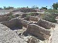
The Mesa Grande Ruins, an ancient Hohokam site.
-
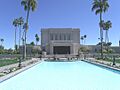
The Mesa Arizona Temple, a historic landmark in the city.
-
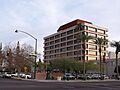
Mesa City Hall in downtown Mesa.


See also
 In Spanish: Mesa (Arizona) para niños
