Chandler, Arizona facts for kids
Quick facts for kids
Chandler, Arizona
|
||
|---|---|---|
|
City
|
||
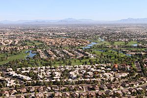
Aerial view of Chandler
|
||
|
||
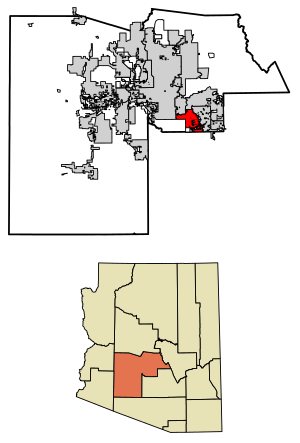
Location in Maricopa County, Arizona
|
||
| Country | United States | |
| State | ||
| County | Maricopa | |
| Founded | May 17, 1912 | |
| Government | ||
| • Type | Council-Manager | |
| Area | ||
| • City | 65.55 sq mi (169.77 km2) | |
| • Land | 65.48 sq mi (169.58 km2) | |
| • Water | 0.07 sq mi (0.18 km2) | |
| Elevation | 1,211 ft (370 m) | |
| Population
(2020)
|
||
| • City | 275,987 | |
| • Estimate
(2022)
|
280,711 | |
| • Rank | US: 78th | |
| • Density | 4,226.4/sq mi (1,627.45/km2) | |
| • Metro | 4,948,203 | |
| • Demonym | Chandlerite | |
| Time zone | UTC−7 (MST (no DST)) | |
| ZIP Codes |
85224-85226, 85244, 85246, 85248-85249, 85286
|
|
| Area code(s) | 480 | |
| FIPS code | 04-12000 | |
| GNIS feature ID | 2409433 | |
Chandler is a big city in Maricopa County, Arizona, United States. It's like a neighbor to Phoenix, being part of the larger Phoenix-Mesa-Chandler Metropolitan Statistical Area. Chandler is the fourth-largest city in Arizona. Only Phoenix, Tucson, and Mesa are bigger. It's also part of an area called the East Valley.
In 2020, about 275,987 people lived in Chandler. This was a big jump from 236,123 people in 2010. Chandler is a busy place for businesses and technology companies. Big companies like Intel, Northrop Grumman, Wells Fargo, PayPal, and Boeing have offices or factories here.
Contents
History of Chandler
In 1891, a man named Dr. Alexander John Chandler moved to a ranch south of Mesa. He was from Canada and was the first animal doctor (veterinary surgeon) in the Arizona area. He learned a lot about how to bring water to dry land (irrigation).
By 1900, Dr. Chandler owned a lot of land, about 18,000 acres (73 square kilometers). He started planning a new town on his ranch. The office for the new town opened on May 16, 1912.
The first part of the town was set up with streets like Galveston, Frye, Hartford, and Hamilton. By 1913, the town had a center with the Hotel San Marcos. This hotel was special because it had the first grass golf course in Arizona! Chandler High School opened in 1914. Chandler officially became a city on February 16, 1920. This happened after 186 people asked the county to make it a city.
Chandler's economy stayed strong during the Great Depression. However, a few years later, the price of cotton dropped a lot. This hurt the city's residents more. Dr. Chandler even lost his Hotel San Marcos because of this. Later, in 1941, Williams Air Force Base was built nearby. This helped Chandler's population grow a bit, but by 1950, only 3,800 people lived there.
By 1980, Chandler's population had grown to 30,000. Since then, it has grown very quickly, just like the rest of the Phoenix area. Homes and businesses have replaced old farms. The number of people living in Chandler has almost doubled in the last 20 years. This growth was helped by companies like Microchip, Motorola, and Intel building factories here.
Geography of Chandler
Chandler covers about 65.55 square miles (169.77 square kilometers). Only a tiny part of this area is water. The middle of Chandler is about 22 miles (35 kilometers) southeast of Downtown Phoenix.
Chandler is close to the San-Tan mountain range. These mountains are part of the Gila River Indian Community land.
The city of Chandler is split into three main areas: North Chandler, West Chandler, and South Chandler. These areas are separated by major highways called Loop 202 (Santan Freeway) and Loop 101 (Price Freeway).
Climate in Chandler
| Climate data for Chandler, AZ | |||||||||||||
|---|---|---|---|---|---|---|---|---|---|---|---|---|---|
| Month | Jan | Feb | Mar | Apr | May | Jun | Jul | Aug | Sep | Oct | Nov | Dec | Year |
| Record high °F (°C) | 89 (32) |
95 (35) |
99 (37) |
106 (41) |
118 (48) |
116 (47) |
119 (48) |
115 (46) |
113 (45) |
107 (42) |
97 (36) |
86 (30) |
119 (48) |
| Mean daily maximum °F (°C) | 67 (19) |
71 (22) |
77 (25) |
85 (29) |
94 (34) |
104 (40) |
106 (41) |
104 (40) |
99 (37) |
89 (32) |
75 (24) |
67 (19) |
87 (30) |
| Daily mean °F (°C) | 54 (12) |
58 (14) |
63 (17) |
70 (21) |
78 (26) |
87 (31) |
92 (33) |
90 (32) |
85 (29) |
74 (23) |
61 (16) |
54 (12) |
72 (22) |
| Mean daily minimum °F (°C) | 41 (5) |
45 (7) |
49 (9) |
54 (12) |
61 (16) |
70 (21) |
77 (25) |
76 (24) |
70 (21) |
59 (15) |
47 (8) |
40 (4) |
57 (14) |
| Record low °F (°C) | 15 (−9) |
19 (−7) |
24 (−4) |
30 (−1) |
37 (3) |
43 (6) |
54 (12) |
51 (11) |
40 (4) |
30 (−1) |
22 (−6) |
17 (−8) |
15 (−9) |
| Average precipitation inches (mm) | 1.01 (26) |
1.03 (26) |
1.19 (30) |
0.33 (8.4) |
0.17 (4.3) |
0.06 (1.5) |
0.89 (23) |
1.14 (29) |
0.89 (23) |
0.81 (21) |
0.77 (20) |
0.98 (25) |
9.20 (234) |
| Source: The Weather Channel | |||||||||||||
People of Chandler
| Historical population | |||
|---|---|---|---|
| Census | Pop. | %± | |
| 1930 | 1,378 | — | |
| 1940 | 1,239 | −10.1% | |
| 1950 | 3,799 | 206.6% | |
| 1960 | 9,531 | 150.9% | |
| 1970 | 13,763 | 44.4% | |
| 1980 | 29,673 | 115.6% | |
| 1990 | 89,862 | 202.8% | |
| 2000 | 176,581 | 96.5% | |
| 2010 | 236,123 | 33.7% | |
| 2020 | 275,987 | 16.9% | |
| 2022 (est.) | 280,711 | 18.9% | |
| U.S. Decennial Census | |||
In 2020, Chandler had a population of 275,987 people. The city is very diverse, with people from many different backgrounds living there.
As of 2022, there were about 280,684 people and 106,712 homes in Chandler. About 34.4% of homes had children under 18 living there. About 24.2% of homes had people aged 65 or older. The average household had about 2.61 people.
The average age of people in Chandler was 37 years old. For every 100 females, there were about 105.8 males.
The average income for a household was about $98,664. About 7.6% of the people in Chandler lived below the poverty line.
Many people in Chandler have German, Irish, and English backgrounds. There are also many people with Hispanic or Latino heritage.
Chandler's Economy
Chandler is a hub for technology and manufacturing. The computer chip maker Intel has two large locations here. Many other high-tech companies also work with Chandler. These companies employed about 25% of the city's workers in 2007.
Since 2003, more than 2,900 new jobs have been created along the Price and Santan freeways. These areas are known as the Price Road Corridor. The Chandler Fashion Center, a large shopping mall, opened in 2001.
Some companies that have their main offices in Chandler include Keap, Microchip, and Rogers.
Top Employers in Chandler
Here are some of the biggest employers in Chandler:
| # | Employer | # of Employees |
|---|---|---|
| 1 | Intel | 12,000 |
| 2 | Wells Fargo | 5,500 |
| 3 | Chandler Unified School District | 4,900 |
| 4 | Bank of America | 3,600 |
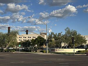
| 5 | Chandler Regional Medical Center / Dignity Health | 2,500 |
| 6 | Northrop Grumman | 2,150 |
| 7 | Chandler–Gilbert Community College | 1,900 |
| 8 | City of Chandler | 1,800 |
| 9 | Microchip Technology (HQ) | 1,700 |
| 10 | NXP Semiconductors | 1,700 |
| 11 | PayPal | 1,500 |
| 12 | Insight Enterprises | 1,400 |
| 13 | Microchip Technology | 1,500 |
| 14 | Verizon | 1,400 |
| 15 | Bashas' (HQ and Distribution Center) | 1,100 |
Arts and Culture in Chandler
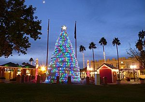
Chandler has a fun annual event called the Ostrich Festival. It takes place at Tumbleweed Park. This festival celebrates a time in the 1910s when ostrich farms in the area grew feathers for women's hats.
Chandler also has a special tradition each year: lighting a Christmas tree made from tumbleweeds! This tradition started in 1957 when the city wanted a unique way to decorate for the holidays.
Places where you can enjoy arts and culture include:
- Chandler Center for the Arts: This is a large place for performances, with seats for 1,500 people.
- The Vision Gallery: Here you can see beautiful art from local artists.
- The Arizona Railway Museum: Located at Tumbleweed Park, it's a great place to learn about trains.
- The Chandler Museum: This museum is near the Chandler Fashion Center.
Several important places in Chandler are listed on the National Register of Historic Places. These include the McCullough–Price House and the San Marcos Hotel.
The Chandler Public Library system serves the city and the wider East Valley area. The main library is in Downtown Chandler. There are also branches called Sunset, Basha, and Hamilton.
Parks and Recreation in Chandler
Tumbleweed Park is a popular spot. It hosts the yearly Ostrich Festival, the Fourth of July Fireworks Festival, and the annual Day of Play. The park also has a recreation center with fitness equipment.
The Hamilton Aquatic Center is a swimming facility located at Hamilton High School.
The Nozomi Aquatic Center is another swimming facility. It has a 25-yard, 8-lane competition pool.
Veterans Oasis Park is at the highest point in the city. It's a great place for nature lovers, with a wildlife area and trails for walking and horse riding.
Education in Chandler
Schools for Kids and Teens
Chandler is served by several school districts. The main one is the Chandler Unified School District. Other districts that serve parts of Chandler include Kyrene Elementary School District, Tempe Union High School District, Mesa Public Schools, and Gilbert Public Schools.
There are also Catholic schools and charter schools like Basis Schools, Seton Catholic Preparatory, and Legacy Traditional Schools.
Colleges and Universities
For education after high school, Chandler has:
- The University of Arizona Chandler
- International Baptist College
- Chandler-Gilbert Community College, which has about 13,000 students.
Chandler's Infrastructure
Transportation
Airports
Chandler Municipal Airport is a smaller airport for general aviation. Stellar Airpark is another airport, privately owned but open to the public.
Freeways and Highways
Chandler is connected by three main highways:
- Loop 202, also called the Santan Freeway. It divides North and South Chandler.
- Loop 101, known as the Price Freeway. It was fully finished in 2001.
- Interstate 10, a major highway that runs along the city's western edge.
Railroads
Chandler has two train lines that are part of the Union Pacific Railroad network.
Healthcare
The main hospitals in Chandler are Chandler Regional Medical Center and Banner Ocotillo Medical Center.
Famous People from Chandler
Many interesting people have connections to Chandler, Arizona:
- Ryan Bader, a mixed martial arts (MMA) fighter
- Cody Bellinger, a baseball player for the Chicago Cubs
- Hunter Bishop, a baseball player
- Jakob Butturff, a professional bowler
- Zora Folley, a professional heavyweight boxer
- Austin Hollins, a basketball player for Maccabi Tel Aviv
- Markus Howard, a record-setting basketball player for Marquette
- Cameron Jordan, a football player for the New Orleans Saints
- Shawn Michaels, a famous professional wrestler and WWE Hall of Famer
- Patrick Murphy, a baseball pitcher for the Minnesota Twins
- James Rallison (TheOdd1sOut), a popular YouTube animator
- Chase Lucas, a football player for the Detroit Lions
- Waylon Jennings, a famous American singer-songwriter and musician
Sister Cities
Chandler has two sister cities, which are like special international friends:
 Tullamore, County Offaly, Ireland
 Tainan, Taiwan
See also
 In Spanish: Chandler (Arizona) para niños
 | James Van Der Zee |
 | Alma Thomas |
 | Ellis Wilson |
 | Margaret Taylor-Burroughs |


