
List of counties in Arizona facts for kids
Quick facts for kids Counties of Arizona |
|
|---|---|
| Category | Federal Unit |
| Location | State of Arizona |
| Number | 15 |
| Populations | 9,369 (Greenlee) – 4,585,871 (Maricopa) |
| Areas | 1,238 square miles (3,210 km2) (Santa Cruz) – 18,661 square miles (48,330 km2) (Coconino) |
| Government | County government |
| Subdivisions | cities, towns, unincorporated communities, census designated place |

Arizona is a state in the southwestern United States. It has 15 special areas called counties. Think of a county as a large district or region within a state. Each county has its own local government that helps manage things like roads, public safety, and local services.
When Arizona became a U.S. territory in 1862, four counties were created in 1864: Mohave, Pima, Yavapai, and Yuma. One county, Pah-Ute, was briefly created from Mohave County but later rejoined it. Most of Arizona's counties were formed before it became a state in 1912. The newest county, La Paz County, was created in 1983.
Many counties in Arizona are named after important things. Eight counties are named after different Native American groups who live in Arizona. For example, Cochise County is named after a famous Native American leader. Other counties are named after natural features like rivers or mountains. These include Gila County (named after the Gila River), Santa Cruz County (named after the Santa Cruz River), Pinal County (named after Pinal Peak), and Graham County (named after Mount Graham). La Paz County is named after an old settlement, and Greenlee County is named after an early explorer.
Counties in Arizona follow rules set by the state. They are managed by a group of elected officials called a Board of Supervisors. This board helps make decisions for the county, like managing local laws, planning land use, and collecting money for services. Arizona's postal abbreviation is AZ, and its FIPS code is 04.
Contents
Arizona's Counties: A Closer Look
This section lists all 15 counties in Arizona, showing when they were created and how they got their names.
| County |
FIPS code | County seat | Est. | Formed from | Etymology | Population | Area | Map |
|---|---|---|---|---|---|---|---|---|
| Apache County | 001 | St. Johns | 1879 | Yavapai County | Named after the Apache people. The word Apache comes from a Zuni word meaning "Navajos" or a Yavapai word meaning "enemy". | 65,036 | 11,218 sq mi (29,054 km2) |
 |
| Cochise County | 003 | Bisbee | 1881 | Pima County | Named after Cochise, a famous Chiricahua Apache chief. He led an uprising in 1861. The name Cochise is an English version of a word meaning "oak". | 124,640 | 6,219 sq mi (16,107 km2) |
 |
| Coconino County | 005 | Flagstaff | 1891 | Yavapai County | Named after the Havasupai, Hualapai, and/or Yavapai people. The name comes from the Hopi word Kohonino. | 144,472 | 18,661 sq mi (48,332 km2) |
 |
| Gila County | 007 | Globe | 1881 | Maricopa and Pinal Counties | Named after the Gila River, a river that flows into the Colorado River. It might come from an Apache word for "mountain". | 54,003 | 4,796 sq mi (12,422 km2) |
 |
| Graham County | 009 | Safford | 1881 | Apache and Pima Counties | Named after Mount Graham, a mountain in the Pinaleño Mountains. The mountain itself is named after James Duncan Graham, an engineer. | 39,525 | 4,641 sq mi (12,020 km2) |
 |
| Greenlee County | 011 | Clifton | 1909 | Graham County | Named after Mason Greenlee, an early explorer. This name was chosen during the process of creating the county. | 9,369 | 1,848 sq mi (4,786 km2) |
 |
| Maricopa County | 013 | Phoenix | 1871 | Pima and Yavapai Counties | Named after the Maricopa people. The meaning of the name is not fully known. | 4,585,871 | 9,224 sq mi (23,890 km2) |
 |
| Mohave County | 015 | Kingman | 1864 | — | Named after the Mohave people. Their own name for themselves means "along the water," referring to the Colorado River. | 223,682 | 13,470 sq mi (34,887 km2) |
 |
| Navajo County | 017 | Holbrook | 1895 | Apache County | Named after the Navajo people. The name Navajo comes from a Tewa word meaning "big field". | 109,175 | 9,959 sq mi (25,794 km2) |
 |
| Pima County | 019 | Tucson | 1864 | — | Named after the Pima people. The name Pima is a Spanish word that came from an O'odham phrase meaning "(I) don't know". | 1,063,162 | 9,189 sq mi (23,799 km2) |
 |
| Pinal County | 021 | Florence | 1875 | Maricopa and Pima counties | Named after Pinal Peak. The name might come from a Spanish word meaning "place of pines". Pinal Peak is now in Gila County. | 484,239 | 5,374 sq mi (13,919 km2) |
 |
| Yavapai County | 025 | Prescott | 1864 | — | Named after the Yavapai people. The Yavapé are one of the main groups of Yavapai people. | 249,081 | 8,128 sq mi (21,051 km2) |
 |
| Yuma County | 027 | Yuma | 1864 | — | Yuma was an older name for the Quechan people. It came from an O'odham word. | 213,221 | 5,519 sq mi (14,294 km2) |
 |
Counties That Are No Longer Part of Arizona
Some areas that were once considered part of Arizona are now in other states or have been renamed.
- Doña Ana County, New Mexico Territory
- Rio Arriba County, New Mexico Territory
- Santa Ana County, New Mexico Territory
- Socorro County, New Mexico Territory
- Taos County, New Mexico Territory
- Valencia County, New Mexico Territory
Counties That No Longer Exist
- Pah-Ute County, Arizona Territory (1865–1871): This county used to exist but was later divided. Parts of it are now in Clark County, Nevada and Mohave County, Arizona.
Ideas for New Counties
Over the years, people have suggested creating new counties in Arizona. Here are a couple of examples:
- Butte County: In 1897, there was a plan to split Maricopa County into two, with Tempe as the main town for the new county. Later, in 1900 and 1913, there were more ideas to divide Maricopa County, with Mesa as the proposed county seat.
- Sierra Bonita County: This county was suggested in 1885. The town of Willcox was planned to be its county seat. However, the idea did not pass by just one vote.
See also
 In Spanish: Anexo:Condados de Arizona para niños
- Arizona Association of Counties
Images for kids
-
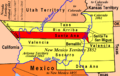
Counties of the Territory of New Mexico, 1852.

