Santa Ana County, New Mexico Territory facts for kids

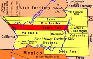
Santa Ana County was an important area in New Mexico a long time ago. It was one of seven original "partidos" (which were like districts or regions) when New Mexico was under Mexican rule. Later, when the United States took over, it became a U.S. Territorial county from 1852 until 1876. In 1876, it joined with Bernalillo County. Today, Santa Ana County no longer exists as its own official area.
The county was named after the Pueblo of Santa Ana, which is a Native American community. The original main town, or "county seat," for Santa Ana County is now called Fort Defiance, Arizona.
Contents
What Was Santa Ana County?
Santa Ana County was a part of New Mexico that existed for a short time. It helped organize the land and people during a period of big changes.
From Mexican Rule to U.S. Territory
When New Mexico was part of Mexico, it was divided into seven main areas called "partidos." Santa Ana County was one of these. After the Mexican-American War, the United States gained control of New Mexico. In 1852, Santa Ana County officially became a U.S. Territorial county. This meant it was an area governed by the U.S. government, but it wasn't yet a state.
Why Did It Disappear?
Santa Ana County existed as a U.S. Territorial county for about 24 years. In 1876, the government decided to make changes to how New Mexico was organized. Santa Ana County was then combined with Bernalillo County. This is why you won't find Santa Ana County on maps today as a separate county.
Where Was Its Center?
The main town or "county seat" for Santa Ana County was a place that is now known as Fort Defiance, Arizona. This shows how the borders and names of places can change over time, especially in areas that were once territories.
 | Anna J. Cooper |
 | Mary McLeod Bethune |
 | Lillie Mae Bradford |

