
Fort Defiance, Arizona facts for kids
Quick facts for kids
Fort Defiance, Arizona
|
|
|---|---|

Fort Defiance, New Mexico (now Arizona) by Seth Eastman (1808–1875), painted 1873
|
|

Location in Apache County and the state of Arizona
|
|
| Country | United States |
| State | Arizona |
| County | Apache |
| Area | |
| • Total | 6.41 sq mi (16.60 km2) |
| • Land | 6.41 sq mi (16.60 km2) |
| • Water | 0.00 sq mi (0.00 km2) |
| Elevation | 6,798 ft (2,072 m) |
| Population
(2020)
|
|
| • Total | 3,541 |
| • Density | 552.59/sq mi (213.36/km2) |
| Time zone | UTC-7 (MST) |
| ZIP code |
86504
|
| Area code | 928 |
| FIPS code | 04-24460 |
| GNIS feature ID | 2408236 |
Fort Defiance is a community in Apache County, Arizona, United States. It is also part of the Navajo Nation. In 2020, about 3,541 people lived there. The Navajo name for Fort Defiance is Tséhootsooí ([tsʰéhòːtsʰòː.í]).
Contents
History of Fort Defiance
Fort Defiance was first noticed by the U.S. military in 1849. Colonel John Washington explored the area. The fort was officially started on September 18, 1851. Colonel Edwin V. Sumner built it to have a military base in the Navajo territory. This was the first military post in what is now Arizona.
Early Conflicts and Battles
The fort was built on land that the Navajo people used for grazing their animals. The U.S. government stopped them from using it. This led to many fights. The fort was attacked twice, once in 1856 and again in 1860.
In 1861, at the start of the American Civil War, the army left Fort Defiance. But Navajo raids continued in the area. So, in 1863, Brigadier General James H. Carleton sent Kit Carson to bring order. The fort was reopened as Fort Canby to help Carson's operations.
The Long Walk and Reestablishment
General Carleton's plan was very harsh. Thousands of Navajo people were forced to go on a "Long Walk" of about 450 miles (724 km). They were held near Fort Sumner, New Mexico. Many of their animals were also destroyed.
After this campaign in 1864, the fort was left again. The remaining Navajo people burned it, leaving only its walls. In 1868, the Navajo Treaty of 1868 allowed the Navajo to return to some of their land. Fort Defiance was then reopened as an Indian agency. In 1870, the first government school for the Navajo was started there.
Fort Defiance Today
Today, the area of Fort Defiance has many buildings built from the 1930s until now. These buildings are used by different government groups. These include the Bureau of Indian Affairs, Indian Health Service, and the Navajo Nation. The biggest building was the Fort Defiance Indian Hospital until 2002.
Geography
Fort Defiance is located on the Defiance Plateau. It is about 4 miles (6.4 km) north of Window Rock.
The community covers a total area of about 6.41 square miles (16.60 km²). All of this area is land.
People and Language
Fort Defiance is home to many people. In 2000, about 54.6% of people spoke the Navajo at home. About 45.4% spoke English at home.
| Languages (2000) | Percent |
|---|---|
| Spoke Navajo at home | 54.6% |
| Spoke English at home | 45.4% |
In 2000, there were 4,061 people living in Fort Defiance. Many households had children under 18. The average household had about 3.61 people. The median age of people in Fort Defiance was 26 years old.
Education
Fort Defiance is part of the Window Rock Unified School District. Students in Fort Defiance go to Window Rock Elementary School, Tséhootsooí Middle School, and Window Rock High School.
The Navajo Nation also runs Tséhootsooí Diné Bi'Ólta'. This is a special school for grades K-8 in Fort Defiance. It teaches completely in the Navajo language. The school aims to help children learn and use the Navajo language. In kindergarten and first grade, all lessons are in Navajo. English is slowly added in later grades.
Images for kids
-
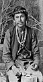
Navajo silversmith Náltsos Nigéhani, also known as Jake, who carried mail between Fort Wingate and Fort Defiance.
-
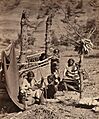
A Navajo family with a loom near Old Fort Defiance in 1873.


See also
 In Spanish: Fort Defiance (Arizona) para niños
