
Defiance Plateau facts for kids
Quick facts for kids
Defiance Plateau
|
|
|---|---|
|
Region
|
|

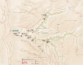
Defiance Plateau, south of Chinle Valley, and east-northeast of Painted Desert-(light tan & arc-shaped)
(Puerco River & valley, from New Mexico attached at southeast of desert) (see 3rd, watershed map) |
|

Defiance Plateau
Location in Arizona
|
|
| Country | United States |
| States | |
| Regions | Painted Desert, (southeast)-Colorado Plateau & Navajo Nation |
| Counties | Apache |
The Defiance Plateau is a large, raised area of land. It's about 75 miles (121 km) long. This plateau is mostly in Apache County, Arizona. Some parts of its eastern side are in San Juan and McKinley Counties, New Mexico.
This plateau is part of a bigger geological feature called the Defiance Uplift. It's like a giant bump in the Earth's surface. The western side of the plateau is next to the famous Painted Desert. Rivers like the Puerco River flow from New Mexico into this area. The Puerco River then joins the Little Colorado River. This river flows through the Painted Desert and eventually reaches the Colorado River near the Grand Canyon.
The Defiance Plateau is bordered by different natural features. The Puerco River forms its southern and southeastern edge. To the northwest, you'll find the Black Mesa. The northern part of the plateau is next to the Chinle Valley. Here, Chinle Creek flows north to meet the San Juan River in Utah.

The northern end of the Defiance Plateau has three cool canyons. Water from these canyons flows west and becomes part of Chinle Creek. One of the most famous is Canyon de Chelly National Monument. There are also two other canyons, Little White House and Three Turkey Canyons.
The Defiance Plateau is located within the Navajo Nation. The capital of the Navajo Nation, Window Rock, Arizona, is found on the plateau's southeastern side, along Black Creek. The highest point on the plateau is a place called Fluted Rock. It stands at about 8,304 feet (2,531 meters) tall.
Contents
What is the Defiance Plateau?

The Defiance Plateau is the main part of a large area that has been pushed up by geological forces. Think of it like a giant, flat-topped mountain. To the north and northeast, you'll find the Lukachukai Mountains. These mountains are part of the plateau's border. They also help form the edge of the Chinle Valley.
South of the Lukachukai Mountains are the Chuska Mountains. These mountains run mostly north-south along the eastern side of the Defiance Plateau. Further south, the Manuelito Plateau in New Mexico connects to the Chuskas. This area forms the eastern border of Black Creek, which flows south.
Southern and Southwestern Borders
The southern edge of the Defiance Plateau is marked by the Puerco River. This river starts in New Mexico and flows southwest. It meets the Little Colorado River at the southeastern edge of the Painted Desert. The Little Colorado River then flows northwest towards the Colorado River.
Many flat-topped hills, called mesas, extend from the plateau. These mesas help direct water into the Little Colorado River. On the southwest side of the Defiance Plateau, you'll find Padre Mesa. North of that is Ganada Mesa, near Ganado, Arizona. Northeast of Ganada Mesa is Oak Creek Mountain. This is where Fluted Rock, the highest point on the plateau, is located.
Northern and Northwestern Borders
The northwestern part of the Defiance Plateau blends into the southeastern part of the Black Mesa. Black Mesa also forms the western border of the Chinle Valley. The southern and southeastern parts of the Chinle Valley become part of the plateau's northern edge.
To the northeast and east are mountain ranges. The Carrizo Mountains stand alone in the northeast. The Lukachukai Mountains are connected to the northern Chuskas. The large Chuska Mountains are attached to the Defiance Plateau on the east. Water from these mountains flows west or northwest into Canyon de Chelly or the southeastern Chinle Valley. In the southern Chuskas, Black Creek and Red Lake help form the southeastern border of the Defiance Plateau.
Central Plateau Region
The central part of the Defiance Plateau is near Sawmill, Arizona. To the northwest of Sawmill is Beautiful Valley. This valley contains Nazlini Wash, which is a stream that flows into the Chinle Creek system. The water for these streams also comes from the southwest, closer to the edge of the plateau near Ganado, Arizona.
Near Sawmill, you'll find Bonito Canyon. This canyon is a stream that flows northwest into the southern-flowing Black Creek. There's a "water divide" (an imaginary line separating water flow) about 3 miles (4.8 km) north-northeast of Sawmill. This divide separates the water that flows into Chinle Creek from other areas.
How to Get to the Defiance Plateau
Several roads help people get to the Defiance Plateau. US 191 travels along the western edge of the plateau. It starts from Interstate 40 in the south. This route follows the Puerco River from New Mexico.
On the southeastern side of the plateau, Indian Route 12 (IR-12, also known as BIA-12) goes north from I-40. It follows the path of Black Creek in Arizona. In the north, IR-12 meets Red Lake and Navajo, NM. IR-12 then turns northeast and crosses New Mexico Road 134 through the Chuska Mountains. It then turns east to meet U.S. 491.
IR-12 also goes north and northeast from NM 134. It follows the western side of the Chuska Mountains. It eventually meets US 191 north of Canyon de Chelly in the Chinle Valley. This route can take you to Round Rock, Arizona.
Arizona State Route 264 crosses the central-southern part of the Defiance Plateau from east to west. Window Rock, Arizona is on the southeastern side, along Black Creek. Ganado, Arizona is in the central-southwestern part of the plateau. The western end of AZ 264 is Tuba City, Arizona, which is near U.S. 89.
Images for kids
-
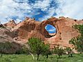
Window Rock (landform)
at Window Rock, Arizona -
Canyon de Chelly National Monument canyons, and the additional 2 canyons at southwest


