Chuska Mountains facts for kids
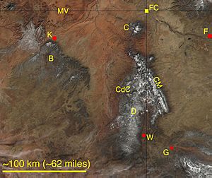
The Chuska Mountains are a long mountain range located in the Navajo Nation, a large Native American territory. They stretch across the border between Arizona and New Mexico in the southwestern United States. These mountains are part of the Colorado Plateau, a huge area of high flat lands.
The Chuska Mountains are about 80 kilometers (50 miles) long and 15 kilometers (10 miles) wide. They are like a high, flat area that has been carved by rivers and streams over time. The average height of these mountains is about 2,740 meters (8,990 feet). The highest point is Roof Butte, which stands at 2,994 meters (9,823 feet) tall. Other tall peaks include Beautiful Mountain and the Lukachukai Mountains.
To the east, the Chuska Mountains meet the San Juan Basin, a lower area. The edge of the mountains here has many landslides where the land has slipped down. To the north, the Chuskas are separated from the Carrizo Mountains by a valley called Red Rock Valley.
Contents
Tallest Peaks of the Chuskas
The Chuska Mountains have several high points. The very tallest is Roof Butte, reaching almost 3,000 meters (9,800 feet) high. Other significant peaks include Matthews Peak and the highest points of the Lukachukai Mountains. These tall peaks offer amazing views of the surrounding landscape.
Forests and Water in the Mountains
A large part of the Chuska Mountains is covered by the Navajo Nation Forest. You can find many types of trees here, like ponderosa pine, spruce, and fir. These trees have been important to the Navajo people for a very long time. In fact, wood from these mountains was used to build ancient pueblos (villages) at Chaco Culture National Historical Park as far back as 974 A.D.
For a while, logging (cutting down trees) in the Chuskas was stopped in 1994 after a lot of discussion. The Navajo tribal government has talked about possibly starting logging again in the future.
The Chuska Mountains and a nearby area called the Defiance Uplift get more rain and snow than the lower lands around them. The snow that melts in winter and the thunderstorms in summer provide more than half of the surface water for the entire Navajo Nation. The beautiful canyons of Canyon de Chelly National Monument were carved by streams that start high up in the Chuska Mountains.
Life and History in the Chuskas
Not many people live in the Chuska Mountains themselves. The towns nearby are small, like Crystal, New Mexico, Lukachukai, Arizona, and Toadlena, New Mexico. These areas are famous for the unique patterns used in Navajo rugs, which are often sold at local trading posts.
A paved road, New Mexico Highway 134, crosses the mountains through a place called Narbona Pass. This pass has a rich history. It was originally known as Beesh Lichii'l Bigiizh, or Copper Pass. This was where Navajo warriors, led by a brave leader named Narbona, won an important battle against a Mexican group.
Later, the pass was renamed Washington Pass, after Colonel John M. Washington. He led a military group against the Navajo. Sadly, Narbona was killed in a fight with Washington's troops in 1849. The pass was later renamed Narbona Pass again to honor the Navajo leader.
How the Mountains Were Formed
The Chuska Mountains and the Defiance Uplift are important high areas on the Colorado Plateau. They were lifted up from the ground a very long time ago, starting about 75 to 80 million years ago. This lifting happened during a period called the Laramide orogeny.
The very top of the Chuska Mountains is made of a special type of rock called Chuska Sandstone. This sandstone is more than 500 meters (1,600 feet) thick in some places. Scientists believe this sandstone formed from huge sand dunes that existed about 35 to 33 million years ago. It was like a giant sand sea!
Later, about 25 million years ago, a type of volcanic rock called minette pushed its way up through the Chuska Sandstone. The two highest points in the range, Roof Butte and Matthews Peak, are actually made of this volcanic rock. You can even see signs of ancient volcanoes, like a "maar" (a wide, flat volcanic crater), along New Mexico Highway 134 in Narbona Pass.
These mountains also hold some natural resources. A small amount of oil has been found in the northwestern part of the Chuskas. Also, Helium-rich gas has been taken from rocks deep underground. In the past, uranium was mined from some of the older rock layers in the Lukachukai Mountains.
 | Misty Copeland |
 | Raven Wilkinson |
 | Debra Austin |
 | Aesha Ash |


