
Colorado Plateau facts for kids


The Colorado Plateau is a huge desert area in the Southwestern United States. It's mostly found around the Four Corners region, where the states of Colorado, New Mexico, Utah, and Arizona meet. A tiny bit also stretches into Nevada. This amazing place covers about 336,700 square kilometers (130,000 square miles)!
Most of the water here comes from the Colorado River and its main branches, like the Green, San Juan, and Little Colorado. The rest of the plateau gets water from the Rio Grande.
The Colorado Plateau is mostly high desert, but it also has scattered forests. In its southwest corner, often called "High Country," you'll find the famous Grand Canyon. Much of the Plateau's look and its long history are connected to the Grand Canyon. People often call this area "Red Rock Country" because of the bright red rocks that are easy to see thanks to the dry weather and erosion. You can spot cool rock shapes like domes, hoodoos, fins, river narrows, natural bridges, and slot canyons.
This region has more National Park Service (NPS) sites than almost anywhere else in the U.S.! It's home to nine national parks, including Grand Canyon, Zion, Bryce Canyon, Arches, and Mesa Verde. There are also 18 national monuments and many other protected areas managed by different groups.
Contents
Amazing Geography of the Plateau


The Colorado Plateau is surrounded by big mountain ranges. To the east and north are parts of the Rocky Mountains, like the Uinta Mountains and Wasatch Mountains in Utah. It's also bordered by the Rio Grande rift and the Basin and Range Province. Some smaller mountain ranges, like the San Juan Mountains, are mixed into the Plateau itself.
The Plateau is divided into six main parts:
- Uinta Basin Section
- High Plateaus Section
- Grand Canyon Section
- Canyon Lands Section
- Navajo Section
- Datil Section
The High Plateaus Section is the tallest part. It has many separate plateaus, like the Awapa Plateau and Aquarius Plateau, which are split by long cracks in the Earth called faults. These plateaus are usually between 1,500 to 3,350 meters (5,000 to 11,000 feet) above sea level.
One of the most famous features here is the Grand Staircase. This is a series of huge cliffs and canyons, including the Grand Canyon itself. As you go north from the Grand Canyon, you see different colored cliffs, each named for its color:
- Chocolate Cliffs
- Vermillion Cliffs
- White Cliffs
- Gray Cliffs
- Pink Cliffs
The dry climate here is because of a "rain shadow" created by the Sierra Nevada mountains far to the west. This means the Colorado Plateau gets only about 15 to 40 centimeters (6 to 16 inches) of rain each year. Higher areas get more rain and have forests with pine, fir, and spruce trees.
A Look at Human History
The Ancestral Puebloan People lived in this region for a very long time, from about 2,000 to 700 years ago.
In 1776–1777, a group from Santa Fe, led by Fathers Dominguez and Escalante, explored much of the Plateau while trying to find a route to California. Later, in 1869 and 1872, U.S. Army Major John Wesley Powell, a geologist, explored the area. Even though he had lost an arm in the American Civil War, Powell and his small team used wooden boats to map this unknown part of the U.S. for the government.
The building of the Hoover Dam in the 1930s and the Glen Canyon Dam in the 1960s changed the Colorado River. The river used to be reddish-brown because of all the dirt it carried (Colorado means "red-colored" in Spanish). Now, with less dirt, it's mostly clear. The green color you sometimes see is from algae on the riverbed rocks.
How the Plateau Was Formed


One amazing thing about the Colorado Plateau is how stable it has been. For the past 600 million years, the rocks here haven't been bent or broken much, unlike the areas around it. To the north and east, the Rocky Mountains were pushed up, and to the west and south, the Earth stretched to create the Basin and Range Province. The Colorado Plateau, however, largely stayed together as one big block.
The oldest rocks in the Grand Canyon are nearly 2 billion years old! These rocks were formed by heat and pressure deep underground. Over millions of years, layers of sedimentary rock were laid down on top of these older rocks. These layers formed in warm, shallow seas and along ancient coastlines as the ocean moved in and out.
About 250 million years ago, huge mountain-building events began in western North America. This caused a lot of land to rise. Rivers, lakes, and inland seas left behind layers of sand and mud. Later, a giant desert created huge sand dunes that turned into rock, forming features like the Navajo Sandstone seen in Zion National Park.
Around 70 million years ago, the Laramide orogeny caused the Colorado Plateau to lift up as one large block. This uplift created the gentle bends and folds you see in the rocks today. Some isolated mountains, like Ute Mountain, were formed by molten rock pushing up from below.
More recently, about 20 million years ago, the Colorado Plateau started to lift even more, as much as 3 kilometers (nearly 2 miles)! As the land rose, rivers like the Colorado River began to cut deeper and faster into the rock. This is how the Grand Canyon started to form less than 6 million years ago.
During the Pleistocene epoch (the Ice Ages), the climate was cooler and wetter. This led to more erosion, with glaciers carving out higher areas and rivers cutting deeper into lower areas.
Life on the Plateau

The Colorado Plateau is home to dry grasslands and areas with shrubs. You'll also find open forests of pinyon-juniper woodland trees, and higher up, mountain forests with pine, fir, and spruce.
Energy Resources
.png)
Generating electricity is a big industry here, mostly from power plants that burn coal. The rocks of the Colorado Plateau also hold lots of oil and natural gas. Major deposits are found in places like the San Juan Basin and the Uinta Basin.
The Colorado Plateau also has important uranium deposits. There was a big "uranium boom" in the 1950s. Today, there are efforts to clean up old mining sites, like the Atlas Uranium Mill near Moab.
You can also find gilsonite here, a unique, shiny, black material used in things like paints and electrical insulation.
Protected Lands: Parks and Monuments
This special region has many amazing natural features like arches, canyons, cliffs, and hoodoos. Many of these places are protected. Areas important for history and culture, like the ancient pueblos of the Ancestral Puebloan people, are also protected.
The Colorado Plateau has the most parklands in North America! It includes:
- Nine U.S. National Parks
- One National Historical Park
- Nineteen U.S. national monuments
- Dozens of wilderness areas
- Millions of acres in U.S. National Forests
- Many state parks and other protected lands.
Lake Powell, a large reservoir created by the Glen Canyon Dam, is also a popular spot.
National Parks
National Monuments
- Aztec Ruins National Monument
- Bears Ears National Monument
- Canyon de Chelly National Monument
- Canyons of the Ancients National Monument
- Cedar Breaks National Monument
- Colorado National Monument
- Dinosaur National Monument
- Grand Canyon-Parashant National Monument
- Grand Staircase–Escalante National Monument
- El Malpais National Monument
- El Morro National Monument
- Hovenweep National Monument
- Navajo National Monument
- Natural Bridges National Monument
- Pipe Spring National Monument
- Rainbow Bridge National Monument
- Sunset Crater National Monument
- Vermilion Cliffs National Monument
- Walnut Canyon National Monument
- Wupatki National Monument
Wilderness Areas
- Ashdown Gorge Wilderness
- Beaver Dam Mountains Wilderness
- Black Ridge Canyons Wilderness
- Cebolla Wilderness
- Bisti/De-Na-Zin Wilderness
- Box-Death Hollow Wilderness
- Cottonwood Point Wilderness
- Dark Canyon Wilderness
- Escudilla Wilderness
- Flat Tops Wilderness
- Grand Wash Cliffs Wilderness
- Kachina Peaks Wilderness
- Kanab Creek Wilderness
- Kendrick Mountain Wilderness
- Lizard Head Wilderness
- Mount Baldy Wilderness
- Mount Logan Wilderness
- Mount Trumbull Wilderness
- Ojito Wilderness
- Paiute Wilderness
- Paria Canyon-Vermilion Cliffs Wilderness
- Pine Valley Mountain Wilderness
- Saddle Mountain Wilderness
- South San Juan Wilderness
- Mount Sneffels Wilderness
- Strawberry Crater Wilderness
- Uncompahgre Wilderness
- High Uintas Wilderness
- Weminuche Wilderness
- West Malpais Wilderness
Other cool protected spots include Barringer Crater, Dead Horse Point State Park, Glen Canyon National Recreation Area, Goblin Valley State Park, Monument Valley, and the San Rafael Swell. The Sedona area in Arizona, known for its beautiful red rock cliffs, is also largely protected within Red Rock State Park and Coconino National Forest.
Images for kids
-
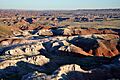
Petrified Forest National Park, Painted Desert
-
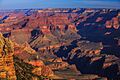
Grand Canyon National Park, South Rim
-
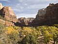
Zion National Park, Zion Canyon in autumn
-
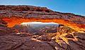
Canyonlands National Park, Mesa Arch
-
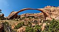
Arches National Park, Landscape Arch
-
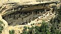
Mesa Verde National Park, Cliff Palace
-
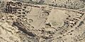
Chaco Culture National Historical Park, Pueblo Bonito

.jpg)
.jpg)


See also
