
Grand Staircase–Escalante National Monument facts for kids
Quick facts for kids Grand Staircase–Escalante National Monument |
|
|---|---|
|
IUCN Category V (Protected Landscape/Seascape)
|
|
.jpg)
A canyon in Grand Staircase–Escalante National Monument
|
|

Grand Staircase–Escalante National Monument
Location in the United States

Grand Staircase–Escalante National Monument
Location in Utah
|
|
| Location | Kane County and Garfield County, Utah, United States |
| Nearest city | Kanab, Utah |
| Area | 1,003,863 acres (4,062.49 km2) |
| Established | September 18, 1996 |
| Visitors | 878,000 (in 2014) |
| Governing body | Bureau of Land Management |
| Website | Grand Staircase–Escalante National Monument |
The Grand Staircase–Escalante National Monument (GSENM) is a special protected area in southern Utah, United States. It was first created in 1996 to protect about 1.9 million acres (7,600 square kilometers) of land. In 2017, its size was changed to about 1 million acres (4,000 square kilometers).
This area is one of the most remote places in the country. It was even the last part of the contiguous United States to be fully mapped!
The monument has three main parts: the Grand Staircase, the Kaiparowits Plateau, and the Canyons of the Escalante. The Bureau of Land Management (BLM) takes care of all these areas. President Bill Clinton made it a national monument in 1996. He used a special law called the Antiquities Act to do this. Grand Staircase–Escalante is the biggest national monument that the BLM manages.
Contents
Managing This Special Place
The Bureau of Land Management (BLM) looks after the Grand Staircase–Escalante National Monument. This is different from many other national monuments, which are often managed by the National Park Service. This monument was the first one in the U.S. to be managed by the BLM.
You can find visitor centers in nearby towns. These include Cannonville, Big Water, Escalante, and Kanab. These centers help people learn about the monument and plan their visits.
Exploring the Geography
The monument stretches across a large part of southern Utah. It goes from towns like Big Water and Kanab, Utah in the southwest. It reaches up to Escalante and Boulder in the northeast.
When it was first created, the monument was huge. It was a bit larger than the state of Delaware. After a change in 2017, it is now about 1 million acres (4,000 square kilometers).

The western part of the monument has the Paunsaugunt Plateau and the Paria River. It is also next to Bryce Canyon National Park. This area shows amazing layers of rock that look like a giant staircase. You can find cool slot canyons here, like Bull Valley Gorge and Willis Creek.
The middle part of the monument has a long, high ridge. It's called the Kaiparowits Plateau from one side. From the other side, it's known as Fifty-Mile Mountain. This mountain stretches all the way to the Colorado River. Its eastern side has a steep cliff about 2,200 feet (670 meters) high. The western side slopes gently.
East of Fifty-Mile Mountain are the Canyons of the Escalante. The monument is bordered by Glen Canyon National Recreation Area to the east and south. This area is popular for hiking and exploring canyons. Some famous spots include Calf Creek Falls and the Devils Garden. You can reach many of these places from the Hole-in-the-Rock Road.

Discovering Ancient Dinosaurs
Since the year 2000, many dinosaur fossils have been found at Grand Staircase–Escalante. Some of these fossils are more than 75 million years old!
In 2002, a person volunteering at the monument found a 75-million-year-old dinosaur. In 2007, this dinosaur was named Gryposaurus monumentensis. This name means "hook-beaked lizard from the monument." This dinosaur was at least 30 feet (9 meters) long and 10 feet (3 meters) tall. It had a very strong jaw with over 800 teeth! Many of these amazing fossils are kept at the Natural History Museum of Utah in Salt Lake City.

Two types of horned dinosaurs were also found here. They were discovered in 2007 by the Utah Geological Survey. These dinosaurs lived about 80 or 81 million years ago. The fossils were found in 2001 and 2002. They were later identified as belonging to Diabloceratops.
In 2013, scientists announced a new dinosaur species called Lythronax argestes. This was a type of tyrannosaur. It lived about 13 million years before the famous Tyrannosaurus. It looks a lot like its later relative. You can see the fossil of Lythronax argestes at the Natural History Museum of Utah.
Human History in the Monument
People started living in this area permanently around 500 AD. Two main groups lived here: the Fremont people and the ancestral Puebloan people. The Fremont hunted and gathered food near the Escalante Valley. The ancestral Puebloans farmed in the canyons.
Both groups grew important crops like corn, beans, and squash. They built homes called pithouses, which had roofs made of brush. They also used natural rock shelters for protection. You can still find old ruins and rock art left by these ancient people throughout the monument.

The first records of white settlers in the area are from 1866. This is when Captain James Andrus led a group to the Escalante River. In 1871, Jacob Hamblin was the first Anglo person to travel the whole length of the Escalante Canyon.
In 1879, a group called the San Juan Expedition traveled through the monument. They were going to start a new Mormon settlement. They found a very difficult path through 1,200-foot (400 meter) sandstone cliffs. This narrow, steep crack in the rocks was called Hole-in-the-Rock. The group had to work for six weeks, using explosives and a pulley system, to get their wagons and animals down the cliff. After that, they built a ferry to cross the Colorado River.
Images for kids
-
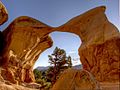
Metate Arch in Devils Garden

See also
 In Spanish: Monumento nacional de Grand Staircase-Escalante para niños
