
Hole in the Rock Trail facts for kids
Quick facts for kids |
|
|
Hole in the Rock Trail
|
|

The Hole in the Rock Trail passes between the Kaiparowits Plateau and the Escalante River
|
|

Location in Utah

Location in the United States
|
|
| Location | Garfield / Kane / San Juan counties, Utah, USA |
|---|---|
| Nearest city | Escalante, Utah |
| Built | 1879 |
| NRHP reference No. | 82004792 |
| Added to NRHP | August 09, 1982 |
The Hole in the Rock Trail is a famous historic path in southern Utah, in the western United States. It stretches from the town of Escalante towards the southeast. This trail was created in 1879 by a group of early settlers, known as Mormon pioneers.
These pioneers were on a special journey called the San Juan Expedition. They traveled across the Colorado River and eventually reached the town of Bluff. Today, the trail is part of the Grand Staircase–Escalante National Monument, the Glen Canyon National Recreation Area, and land managed by the Bureau of Land Management (BLM).
The trail gets its name from a natural rock feature called the Hole in the Rock. A modern dirt road, called the Hole-in-the-Rock Road (BLM Road 200), now follows much of this old trail. This road is important for people visiting amazing places like the Canyons of the Escalante and the Devils Garden. The Hole in the Rock Trail was added to the National Register of Historic Places in 1982, recognizing its important history.
The Trail's Path
The Hole in the Rock Trail is about 180-mile (290 km) long. It begins near Escalante, Utah, and ends in Bluff, Utah. The trail is named after a specific spot where the pioneers had to build a way down to the Colorado River.
This spot was a natural crack in a 1,000-foot (300 m) tall cliff. The pioneers had to make this crack wider so they could lower their wagons down to the river. Once at the river, they could cross it.
Today, the part of the trail below the Hole-In-The-Rock is covered by water from Lake Powell. After crossing the river, the pioneers passed "Register Rocks." Here, they carved their names into the rocks, but these are now also covered by the lake.
The trail then goes up through a narrow path called the Chute. It crosses smooth, rocky sandstone areas to reach Grey Mesa. Getting down from Grey Mesa was another big challenge. The pioneers spent a whole week cutting a road from one ledge to another on the side of the mesa.
They spent another week building a road down Clay Hill Pass. Further along, they were blocked by Comb Ridge. The trail then followed Comb Wash to San Juan Hill, where they had to build yet another road to get up the hill. Finally, the long and difficult journey ended in Bluff.
-
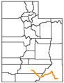
This map shows the entire trail, from Escalante (on the left) to Bluff (on the right).
-
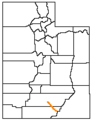
This map shows the current Hole-in-the-Rock Road, which goes from Escalante to the Hole-in-the-Rock.


Images for kids
-
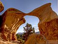
Metate Arch in Devils Garden
-
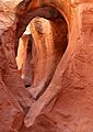
Peek-a-Boo Gulch
-
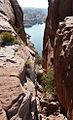
Hole-in-the-Rock, looking down at Lake Powell


