
Devils Garden (Grand Staircase–Escalante National Monument) facts for kids
Quick facts for kids Devils Garden |
|
|---|---|
|
IUCN Category Ib (Wilderness Area)
|
|

Metate Arch
|
|

Devils Garden
Location in the United States

Devils Garden
Location in Utah
|
|
| Location | Garfield County, Utah, United States |
| Nearest city | Escalante, Utah |
| Area | 640 acres (2.6 km2) |
| Elevation | 5243 |
| Designated | December 31, 1979 |
| Governing body | U.S. Bureau of Land Management |
| Official website: https://www.blm.gov/programs/national-conservation-lands/utah/devils-garden-isa | |
The Devils Garden is a super cool place in south central Utah, United States. It's part of the huge Grand Staircase–Escalante National Monument. This special area is known for its amazing rock formations. You'll find tall, skinny rock towers called hoodoos and giant rock bridges called natural arches. All these cool shapes are made from sandstone.
The United States Geological Survey (USGS) officially named it Devils Garden in 1979. It's also known as an "Outstanding Natural Area." This means it's a very important natural place that needs to be protected.
These amazing rock shapes were created by nature over millions of years. Things like wind, water, and ice slowly carved the sandstone. This sandstone formed more than 166 million years ago, during the time of the Jurassic dinosaurs! The Bureau of Land Management (BLM) takes care of Devils Garden. They also manage the entire Grand Staircase–Escalante National Monument.
Contents
Where is Devils Garden?
The Devils Garden is about 17 miles (27 km) southeast of a town called Escalante, Utah. It's in Garfield County, Utah. The area sits high up, at about 5,243 feet (1,598 meters) above sea level. It covers 640 acres, which is like one square mile.
To the west, you'll see tall cliffs called the Straight Cliffs. To the east, there's the Escalante River. This river has carved many narrow slot canyons. North of Devils Garden is the Dixie National Forest. To the south, you'll find the Hole-in-the-Rock and Lake Powell. These are part of the Glen Canyon National Recreation Area.
The main way to get to Devils Garden is by driving on the Hole-in-the-Rock Road. This road is unpaved. It starts about 5 miles (8 km) east of Escalante, off Utah Scenic Byway 12. After driving about 12 miles (19 km) on this road, you'll see a turn-off to the right that leads to Devils Garden. Most of the interesting rock formations are close to the parking lot.
Amazing Rock Formations

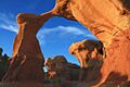
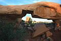
Devils Garden is full of incredible rock shapes. Two famous ones are Metate Arch and Mano Arch. Metate Arch is a thin, natural rock bridge right in the middle of the area. Mano Arch is a thicker arch located a bit southeast of Metate Arch.
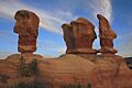
You'll also see many hoodoos here. These are tall, pillar-like rock formations. They come in all sizes and shapes. There's a special group of four hoodoos that many people like to photograph. They don't have an official name from the USGS.
- Metate Arch 37°35′4.4″N 111°24′49.5″W / 37.584556°N 111.413750°W
- Mano Arch 37°35′3.9″N 111°24′48.5″W / 37.584417°N 111.413472°W
- Four hoodoos 37°35′1.6″N 111°24′49.8″W / 37.583778°N 111.413833°W
There aren't any marked trails, but you'll find many paths. These paths lead to the most interesting rock formations. Remember, Devils Garden is a protected area. This means visitors must not disturb any plants, animals, or the delicate soil. Also, climbing on the natural arches is not allowed.
How the Rocks Formed

The rocks at Devils Garden are part of something called the Entrada Sandstone. Geologists say these rocks formed during the Middle Jurassic period. This was about 166 to 174 million years ago. That's when dinosaurs walked the Earth! Scientists are very interested in this area. They have found many dinosaur fossils and footprints here.
The natural arches and hoodoos were, and still are, shaped by nature. This process is called weathering and erosion. Some rock layers are harder than others. These harder layers are like a "caprock" that protects the softer rock below. As the softer rock wears away, the harder caprock remains. This creates the arches and hoodoos we see today.
Many things in nature help shape these rocks.
- Heat and Cold: Daily changes in temperature make the rock expand and shrink. This can cause cracks to form and grow.
- Water: Rain can dissolve tiny parts of the rock, making it weaker. When water freezes in cracks, it expands. This pushes the cracks wider and deeper.
- Wind: Strong winds carry tiny bits of sand. These sand particles act like sandpaper, slowly smoothing and carving the rock surfaces.
- Gravity: Gravity constantly pulls down on the rocks. This can create new cracks or make existing ones bigger.
All these natural forces work together. They slowly carve the amazing shapes you see at Devils Garden.
Visiting Devils Garden
Devils Garden has some basic facilities for visitors. You'll find picnic tables where you can eat. There are also toilet facilities available. However, there is no water, so bring your own! No other services are provided.
You can camp along the Hole-in-the-Rock Road in some spots. But camping is not allowed right at the Devils Garden area or its parking lot. If you want to camp in the national monument, you need to get a free permit beforehand.
Images for kids
-
Metate Arch
-
The four hoodoos
-
Mano Arch
