
Hole in the Rock (rock formation) facts for kids
Quick facts for kids |
|
|
Hole in the Rock
|
|

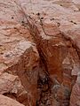
Hole in the Rock, looking down at Lake Powell
|
|

Location in Utah

Location in the United States
|
|
| Location | SE of Escalante, in Glen Canyon National Recreation Area, Kane County, Utah, USA |
|---|---|
| Built | 1879 |
| NRHP reference No. | 75000165 |
| Added to NRHP | November 03, 1975 |
Hole in the Rock is a very narrow and steep crack in the western side of Glen Canyon in southern Utah, United States. This natural opening, along with another canyon on the eastern side of the Colorado River, created a path through an area that was otherwise impossible to cross.
Contents
A Daring Journey
In the fall of 1879, a group of pioneers from The Church of Jesus Christ of Latter-day Saints, called the San Juan Expedition, needed to find a way from central Utah to a new settlement they planned in the far southeastern part of the state. They looked at two longer routes but chose a more direct path.
Finding the Path
This direct path first led them along easier land below the Straight Cliffs of the Kaiparowits Plateau. However, they soon reached the 1,200-foot (400 meter) sandstone cliffs around Glen Canyon. They needed a way to get down to the river and then up the other side. They discovered and named Hole in the Rock. It was a narrow, steep, and rocky crack with a sandy slope that led right down to the river. Directly across the river was Cottonwood Canyon, which looked like a good way to climb up to Wilson Mesa on the other side.
Building the Road
The pioneers worked for months to prepare the road. They used blasting powder to make the upper part wider. They also used hand chisels to carve holes directly into the sandstone cliffs. These holes were used as anchor points for ropes.
The Great Descent
On January 26, 1880, the expedition began their difficult trip down to the river. There were 250 people, 83 large wagons, and over 1,000 animals. They used strong ropes on the wagons. Teams of men and oxen helped lower the wagons through the upper crack, where the slopes were almost 45 degrees steep. Further down, they built a wooden track along a slippery sandstone slope. Posts placed in drilled holes supported horizontal beams, allowing the wagons to pass safely.
After the Crossing
After an even harder journey on the east side of the river, the expedition founded the community of Bluff in southeastern Utah. They used the Hole in the Rock route to bring supplies for only one year. After that, they found an easier way to the north, at Hall's Crossing.
Decades later, miners from the Hoskaninni Mining Company carved steps along the same path the pioneers used. Today, you can still see the blasting holes, anchor points, and marks from the wagons' hubs in the walls of the crack.
Visiting Hole in the Rock Today
You can reach Hole in the Rock in two ways today. The rough Hole in the Rock Trail follows the original path of the 1879 expedition. It runs southeast from near the town of Escalante to a parking area just above the crack.
You can also reach the bottom of the route by boat. It's located at buoy 66 on Lake Powell in the Glen Canyon National Recreation Area.
Hole in the Rock was added to the National Register of Historic Places in 1975. This means it's recognized as an important historical site.
Images for kids
-
Hikers climb through the upper slot of Hole in the Rock (NPS).

More Information
- "Hole-In-The-Rock", an informational brochure distributed by the National Park Service
- "Incredible Passage Through the Hole-In-The-Rock", by Lee Reay (1980) ISBN: 0-934826-06-4
- "The Hole-in-the Rock Trail a Century Later", by Allan Kent Powell (1983), ISBN: 0-87905-885-4
- "Hole-in-the-Rock: An Epic in the Colonization of the Great American West", David E. Miller (1966), ISBN: 0-9639924-1-4
- "Saga of San Juan", by Cornelia Adams Perkins, Marian Gardner Nielson, and Lenora Butt Jones (1968)
- Photographs of the Hole-In-The-Rock at the National Park Service's NRHP database
