Kaiparowits Plateau facts for kids
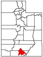
The Kaiparowits Plateau is a huge, raised area of land in southern Utah, in the southwestern United States. It's a major part of the Grand Staircase–Escalante National Monument. This amazing place also includes the Grand Staircase and the Canyons of the Escalante.
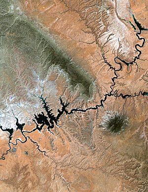
A part of the plateau called Fiftymile Mountain stretches almost to the Colorado River and Lake Powell. It's a very noticeable feature you can see from the Glen Canyon National Recreation Area.
Contents
Exploring the Kaiparowits Plateau's Geography
The Kaiparowits Plateau is shaped a bit like a triangle. It stretches for over 50 mi (80 km) from near Escalante in Garfield County. It goes south and southwest through Kane County, almost reaching the border with Arizona.
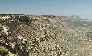
At its southeastern end, the plateau rises dramatically from Lake Powell. It goes up nearly 4,000 ft (1,200 m) to a height of 7,584 ft (2,312 m). The northeastern edge of the plateau has tall, steep cliffs called the Straight Cliffs. Below these cliffs are wide, flat areas made of sandstone, part of the Escalante River basin.
The western edge of the plateau is marked by the Paria River, Cottonwood Canyon, and a ridge called the Cockscomb. The southern part of the plateau has many deep canyons. These canyons were carved by streams like Rock, Last Chance, Warm, Wahweap, and Coyote Creeks. Today, these canyons are big side channels of Lake Powell.
A high part of the plateau is known as Smoky Mountain. This is where you'll find one of the few roads on the plateau. The northwestern end of the plateau blends into the Aquarius Plateau. Canaan Peak, located just south of Highway 12 and Escalante, reaches 9,233 ft (2,814 m) high.
Overall, the plateau covers about 1,650 sq mi (4,300 km2). Much of this area is covered by pinyon and juniper trees, forming a unique woodland.
The Amazing Geology of the Kaiparowits Plateau
Millions of years ago, during the later part of the Cretaceous period, the area that is now the Kaiparowits Plateau looked very different. It was located near the western shore of a huge inland sea called the Western Interior Seaway. The middle of the plateau was a swampy area filled with peat. What we now call the Straight Cliffs was actually the shoreline of this ancient sea.
Further to the west, there was a high land area known as the Sevier Highlands. Rain and rivers washed away rocks and dirt from these Highlands. This material was deposited, forming about 1,500 ft (460 m) of sandstone. This sandstone layer is now called the Straight Cliffs Formation and forms the base of the plateau. Inside this layer, you can still find remnants of the ancient peat, which are now beds of coal.
Later on, during the Cretaceous period, more layers of sandstone formed on top. These are known as the Wahweap and Kaiparowits Formations. Even later, more layers were added, including limestone layers of the Wasatch Formation, which you can see on the surface of the plateau today.
Discovering Fossils on the Kaiparowits Plateau
The sandstone layers of the Kaiparowits Plateau are an incredible treasure chest of Late Cretaceous Period fossils. These fossils are super important for understanding how dinosaurs and early mammals changed over time. The layers here show an unbroken record of life from 70 to 82 million years ago.
What's even cooler is how well-preserved these fossils are! Scientists have found amazing details of bones, teeth, egg shells, and even the footprints of ancient animals.
- In 1998, the skull of a ceratopsid, a horned dinosaur, was found in the Wahweap Formation.
- A type of Struthiomimus, a dinosaur that was carnivorous but didn't have teeth, was identified in the Kaiparowits Formation.
- As recently as 2007, scientists announced the discovery of a unique species of Gryposaurus, a duck-billed dinosaur.
- Fossils of the giant crocodile Deinosuchus have also been found here!
The History of Coal Mining on the Plateau
People started mining coal in parts of the Kaiparowits Plateau way back in the 1870s and 1880s. The Spencer mine opened in 1913. It was said to provide fuel for gold mining activities along the Paria River.
In 1965, a company called Southern California Edison wanted to build a huge coal-fired power plant on the Kaiparowits Plateau. This plant would have been powered by the massive coal deposits found in the plateau. These deposits could have provided up to 4,000,000,000 short tons (3,600×109 kg) of fuel! The electricity from this plant would have gone to big cities like Los Angeles, San Diego, and Phoenix, Arizona.
At first, many thought this plant would bring a lot of jobs and money to this quiet part of southern Utah. However, the idea soon faced strong opposition. Environmental groups, who had recently seen the beautiful canyons of the Colorado River flooded by Lake Powell (behind the Glen Canyon Dam), were very concerned. After ten years of arguments and rising building costs, the plan for the power plant was finally dropped in 1975.
 | Charles R. Drew |
 | Benjamin Banneker |
 | Jane C. Wright |
 | Roger Arliner Young |


