
Lake Powell facts for kids
Quick facts for kids Lake Powell |
|
|---|---|
 |
|

Lake Powell
Location in Arizona

Lake Powell
Location in Utah

Lake Powell
Location in the United States
|
|
| Location | Utah and Arizona, United States |
| Coordinates | 36°56′10″N 111°29′03″W / 36.93611°N 111.48417°W (Glen Canyon Dam) |
| Type | Reservoir |
| Primary inflows | |
| Primary outflows | Colorado River |
| Catchment area | 280,586 km2 (108,335 sq mi) |
| Basin countries | United States |
| Managing agency | National Park Service |
| Built | September 13, 1963 |
| Max. length | 186 mi (299 km) |
| Max. width | 25 mi (40 km) (maximum) |
| Surface area | 161,390 acres (65,310 ha) |
| Average depth | 132 ft (40 m) |
| Max. depth | 583 ft (178 m) |
| Water volume |
|
| Residence time | 7.2 years |
| Shore length1 | 3,057 km (1,900 mi) |
| Surface elevation |
|
| 1 Shore length is not a well-defined measure. | |
Lake Powell is a huge man-made lake, called a reservoir, located on the Colorado River. It stretches across parts of Utah and Arizona in the United States. This beautiful lake is a popular spot for vacations, attracting about two million visitors every year.
When it's completely full, Lake Powell holds an amazing amount of water. It's the second-largest reservoir in the United States by volume. The lake was created by building the Glen Canyon Dam, which flooded Glen Canyon. This area is now part of the Glen Canyon National Recreation Area, managed by the National Park Service.
The lake is named after John Wesley Powell, a Civil War veteran. He explored the Colorado River in 1869 using three wooden boats. Lake Powell is mainly in southern Utah, with a smaller part in northern Arizona. It acts like a giant water bank for states in the Upper Colorado River Basin. These states include Colorado, Utah, Wyoming, and New Mexico. They use the stored water to meet agreements about how much water flows downstream.
Over time, sediments from the Colorado River and San Juan River settle at the bottom of Lake Powell. This means the lake can hold a little less water each year. Some environmental groups have suggested draining Lake Powell to bring Glen Canyon back to its natural state.
Contents
History of Lake Powell
How the Dam Was Planned
In the 1940s and 1950s, the United States Bureau of Reclamation wanted to build several dams on the Colorado River. One idea was to build a dam in Echo Park, which is now Dinosaur National Monument. However, a group led by David Brower of the Sierra Club argued against it. They said Echo Park was too special and beautiful to be flooded.
Because of these concerns, the plan for the dam was moved. The Glen Canyon Dam was then built to help states in the Upper Colorado River Basin. It ensures they can send enough water to the Lower Basin states, like Arizona, Nevada, and California.
Building the Glen Canyon Dam

Construction of the Glen Canyon Dam began on October 1, 1956. President Dwight D. Eisenhower started the process by pushing a button from his office. This blast helped clear tunnels to redirect the river's water. By February 1959, water flowed through these tunnels, allowing the dam's main construction to begin.
Later that year, a bridge was finished. This bridge helped trucks bring in materials for the dam and for the new town of Page, Arizona. Workers poured concrete around the clock starting in June 1960. The last bit of concrete was poured on September 13, 1963. The dam is very tall, about 710 feet (216 meters) high. Building it cost $155 million, and 18 lives were lost. The dam was officially opened by Lady Bird Johnson in September 1966. Later, from 1970 to 1980, equipment was added to produce hydroelectricity (power from water).
How Lake Powell Filled Up
After the Glen Canyon Dam was finished in September 1963, the Colorado River started to back up. This created the new Lake Powell. It took 16 years for the lake to fill up completely, reaching its full level on June 22, 1980. The amount of water in the lake changes a lot. This depends on how much snow melts from the Rocky Mountains each spring.
The highest water level ever recorded was on July 14, 1983. This was during a very big flood on the Colorado River, partly due to a strong El Niño event. The lake reached over 3,708 feet (1,130 meters) above sea level. Lake Powell is mostly in Garfield, Kane, and San Juan counties in southern Utah. A small part is in Coconino County in northern Arizona.
Drought and Water Levels
.png)

Since the year 2000, the Colorado River has had less water flowing into it. This is because of a long period of dry weather, called a megadrought. This has caused the lake's water levels to drop. In 2005, the lake reached its lowest level since it first filled. It was about 150 feet (46 meters) below its full capacity.
Even though water levels went up a bit after 2005, the lake has not filled completely since then. In 2012 and 2013, there was very little runoff into the Colorado River. By April 2014, the lake level had dropped again. To manage water, the amount of water released from Lake Powell was reduced in 2014. This was to keep similar amounts of water in both Lake Powell and Lake Mead. This helps both lakes continue to produce hydroelectric power.
The water levels kept dropping. In April 2022, Lake Powell reached its lowest level since it was filled in 1963. It was only about 22% full. Also, the lake's ability to store water has gone down by 7% since 1963. This is because of sediments from the Colorado and San Juan rivers settling at the bottom. Some studies suggest that storing water in Lake Mead instead of Lake Powell could save a lot of water each year. This has led some environmentalists to call for draining Lake Powell. They want to bring Glen Canyon back to its natural, free-flowing state.
Climate Around Lake Powell
The weather information below is for the Wahweap climate station. This station is located near Lake Powell, just south of the Utah-Arizona border.
| Climate data for Wahweap, AZ | |||||||||||||
|---|---|---|---|---|---|---|---|---|---|---|---|---|---|
| Month | Jan | Feb | Mar | Apr | May | Jun | Jul | Aug | Sep | Oct | Nov | Dec | Year |
| Record high °F (°C) | 69 (21) |
78 (26) |
85 (29) |
94 (34) |
104 (40) |
110 (43) |
120 (49) |
115 (46) |
105 (41) |
96 (36) |
80 (27) |
70 (21) |
120 (49) |
| Mean daily maximum °F (°C) | 47.2 (8.4) |
53.8 (12.1) |
63.0 (17.2) |
72.8 (22.7) |
83.8 (28.8) |
94.1 (34.5) |
98.8 (37.1) |
95.7 (35.4) |
87.7 (30.9) |
73.7 (23.2) |
58.3 (14.6) |
47.1 (8.4) |
73.0 (22.8) |
| Mean daily minimum °F (°C) | 26.9 (−2.8) |
31.8 (−0.1) |
37.8 (3.2) |
44.6 (7.0) |
54.9 (12.7) |
64.1 (17.8) |
71.3 (21.8) |
69.3 (20.7) |
60.7 (15.9) |
48.9 (9.4) |
36.9 (2.7) |
27.4 (−2.6) |
47.9 (8.8) |
| Record low °F (°C) | −2 (−19) |
4 (−16) |
21 (−6) |
16 (−9) |
29 (−2) |
40 (4) |
48 (9) |
51 (11) |
36 (2) |
24 (−4) |
15 (−9) |
3 (−16) |
−2 (−19) |
| Average precipitation inches (mm) | 0.59 (15) |
0.56 (14) |
0.63 (16) |
0.37 (9.4) |
0.36 (9.1) |
0.17 (4.3) |
0.51 (13) |
0.75 (19) |
0.59 (15) |
0.85 (22) |
0.57 (14) |
0.41 (10) |
6.36 (160.8) |
| Average snowfall inches (cm) | 0.2 (0.51) |
0.2 (0.51) |
0 (0) |
0 (0) |
0 (0) |
0 (0) |
0 (0) |
0 (0) |
0 (0) |
0 (0) |
0 (0) |
0.3 (0.76) |
0.7 (1.78) |
| Source: http://www.wrcc.dri.edu/cgi-bin/cliMAIN.pl?az9114 | |||||||||||||
Geology of Glen Canyon
Glen Canyon was formed by the Colorado River over about 5 million years. The river slowly carved through different layers of rock. The land around it, called the Colorado Plateau, rose about 11 million years ago.
You can see rock layers that are over 300 million years old in places like Cataract Canyon. Other formations, like the Moenkopi and Chinle, are found at Lees Ferry. These rocks show that the area was once covered by an ancient inland sea. After the sea dried up, wind blew sand into the area, forming what is now Wingate Sandstone.
Newer rock layers from the Jurassic Period include Kayenta Sandstone. This rock often has a blue-black "desert varnish" on it. Above this is Navajo Sandstone, where many natural arches, like Rainbow Bridge, are found. Other rocks like Entrada Sandstone and Carmel Formation can be seen on top of mesas around Wahweap. The Escalante, Dirty Devil, and San Juan rivers all meet the Colorado River within Lake Powell. The San Juan River has created interesting goosenecks, where the river winds a lot in a small area.
Landmarks and Features to Explore

Lake Powell's main body goes up Glen Canyon. It also fills more than 90 side canyons. The lake reaches up the Escalante River and San Juan River where they join the Colorado River. This gives visitors access to many natural sights and old ruins from the Anasazi culture.
- Glen Canyon Dam: The dam that created Lake Powell. (Arizona)
- Rainbow Bridge: One of the world's largest natural bridges. (Utah)
- Hite Crossing Bridge: The only bridge that crosses Lake Powell.
- Defiance House ruin: An ancient Anasazi ruin.
- Castle Rock
- Cathedral in the Desert
- San Juan goosenecks
- Gregory Butte
- Gunsight Butte
- Lone Rock
- Alstrom Point
- Kaiparowits Plateau
- Hole-in-the-Rock crossing
- The Rincon
- Three-Roof Ruin
- Padre Bay
- Waterpocket Fold
- Antelope Island: Located mostly in Arizona, near Page.
Fun Activities and Access
.jpg)
It's mostly surrounded by steep sandstone cliffs, so you can only get to the lake at special marinas.
- Lee's Ferry
- Page and Wahweap Marina
- Antelope Point Marina
- Halls Crossing, Utah Marina
- Bullfrog Marina
- Hite Marina
Some marinas can only be reached by boat:
- Dangling Rope Marina
- Rainbow Bridge National Monument
- Escalante Subdistrict
Glen Canyon National Recreation Area welcomes over two million visitors each year. People enjoy boating, fishing, waterskiing, jet-skiing, and hiking. There are campgrounds at each marina. Many visitors also like to rent a houseboat or camp in a quiet spot in the canyons.
The Castle Rock Cut is an important channel for boats. It was made to help boaters travel faster between the Glen Canyon Dam and other parts of Lake Powell. This saves about an hour of travel time. The cut has been made deeper several times, so boats can still use it during dry periods. However, during the long drought in the 21st century, the lake has dropped so much that the cut has dried up. This happened most recently in 2013. Making the cut deeper is expensive, but boaters say it makes travel safer and saves fuel.
It's important to be safe when boating on Lake Powell. The lake has many winding canyons, and it's easy to get lost if you don't have good maps. Also, you are not allowed to bury human or pet waste in Glen Canyon National Recreation Area. If you camp far from a marina, you must bring a portable toilet.
You can get to the southwestern part of Lake Powell in Arizona using U.S. Route 89 and State Route 98. To reach the northeastern part of the lake in Utah, use State Route 95 and State Route 276.
Fishing at Lake Powell
Fishing is a very popular activity at Lake Powell. Some of the best places to fish include Bullfrog Basin, Padre Bay, Wahweap Bay, The San Juan Arm, and Halls Creek Bay.
Fish Species in the Lake
Many different kinds of fish live in Lake Powell. Some native species in the Colorado River Basin are currently part of special efforts to help them recover.
- Other Fish*
- Crappie
- Sunfish
- Channel catfish
- Northern pike
- Walleye
- Common carp
- Razorback sucker
- Brown trout
- Bonytail chub
- Gizzard shad
Invasive Species: Quagga Mussels
Zebra and quagga mussels are not native to the United States. They first appeared in the 1980s, brought by ships from other countries. These tiny invaders spread quickly to many lakes and rivers, even reaching the western United States. By 2008, quagga mussels were found in other reservoirs along the Colorado River, like Lakes Mead and Havasu.
Quagga mussels can cause big problems for the environment. They compete with native species for food, which can harm the fish that live there. These mussels also attach to hard surfaces and can clog pipes, including those used for hydroelectric power. This creates expensive problems for water managers.
To stop the spread, Lake Powell started monitoring for mussels in 1999. In 2001, special stations were set up at marinas to clean boats with hot water. In 2007, after mussels were found in Lake Mead, new plans were made to protect Lake Powell. Even though some early tests were false alarms, adult quagga mussels were found in Lake Powell in 2013.
In 2009, Lake Powell started requiring all boats to have a mussel certificate before entering the lake. This was to prevent boats from bringing mussels into the water. Despite these efforts, quagga mussel DNA was found in 2012, and live mussels were found at Wahweap Marina in 2013. The National Park Service tried a program to remove mussels by divers.
Pipeline Proposal
The Washington County Water Conservancy District has suggested building the Lake Powell Pipeline. This pipeline would take water from Lake Powell to provide drinking water for communities in Washington County.
Images for kids
-
Glen Canyon Dam and Colorado River bridge
-
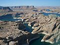
Lake Powell in 2007
-
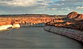
Lake Powell, looking southwest at sunrise
-
Lake Powell in Arizona. The dam is under the arch bridge (upper right end of the water)
-
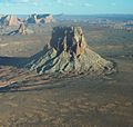
Aerial view of Tower Butte Arizona
-
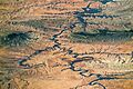
Lake Powell and Grand Staircase–Escalante from space, 2016
-
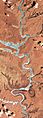
Lake Powell from space, 2016


See also
 In Spanish: Lago Powell para niños
