
Gregory Butte facts for kids
Quick facts for kids Gregory Butte |
|
|---|---|

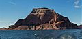
Aerial view of north aspect
|
|
| Highest point | |
| Elevation | 4,651 ft (1,418 m) |
| Prominence | 1,011 ft (308 m) |
| Isolation | 1.55 mi (2.49 km) |
| Parent peak | Point 5246 |
| Geography | |

Gregory Butte
Location in Utah

Gregory Butte
Location in the United States
|
|
| Location | Glen Canyon National Recreation Area San Juan County, Utah, U.S. |
| Parent range | Colorado Plateau |
| Topo map | USGS Gregory Butte |
| Geology | |
| Age of rock | Jurassic |
| Type of rock | Entrada Sandstone |
| Climbing | |
| Easiest route | class 5.x climbing |
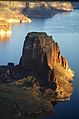
Gregory Butte is a tall, flat-topped hill called a butte. It stands 4,651 feet (about 1,418 meters) high. You can find it in the Glen Canyon National Recreation Area in southern Utah.
This amazing sandstone landmark is a big part of the Lake Powell area. It rises almost 1,000 feet above the lake! Before Lake Powell was created in the 1970s, Gregory Butte was located right next to a bend in the Colorado River.
Geology and History of Gregory Butte
Gregory Butte is made of a type of rock called Entrada Sandstone. This sandstone formed about 160 million years ago during the Jurassic period. Back then, the area was a huge sandy desert, like a giant sand sea! The sand was originally laid down as muddy sand on a flat area near the ocean.
The name "Gregory Butte" became official in 1977. It was named by the United States Board on Geographic Names. The butte honors geologist Herbert E. Gregory (1869–1952). He studied and mapped many of the rocks in the Colorado Plateau, especially in the areas that are now Navajo Nation land in Arizona and Utah.
Climate Around Gregory Butte
The area around Gregory Butte has a desert climate. This means it has very hot and dry summers. The winters are chilly, but there isn't much snow. This type of climate is known as an arid climate.
Images for kids
-
Northeast aspect
-
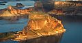
Aerial view from east
-
Aerial view from southeast


