
Waterpocket Fold facts for kids


The Waterpocket Fold is a giant wrinkle in the Earth's crust located in southern Utah, United States. It stretches for almost 100 miles (160 km) through Wayne, Garfield, and Kane counties. This amazing natural feature looks like a long, narrow mountain range, but it's actually a single, bent layer of rock.
This unique landform was created millions of years ago during a time when huge forces pushed and folded the Earth's surface. The Waterpocket Fold is a special type of fold called a monocline. This means one side of the rock layers dropped down compared to the other side. It's like pushing a rug against a wall and watching it buckle upwards.
Contents
Exploring the Waterpocket Fold
The Waterpocket Fold is the main feature of Capitol Reef National Park in southern Utah. This park protects the fold and allows visitors to see its incredible geology up close.
How Can You See This Amazing Fold?
You can explore the Waterpocket Fold using three main scenic routes within Capitol Reef National Park. Each route offers different views of this massive geological structure.
The Park's Scenic Drive
The park's Scenic Drive is a popular way to see the fold. It leads to a famous spot called the Golden Throne. This landmark is a large, golden-colored rock formation that stands out against the landscape.
Utah State Route 24
Utah State Route 24 crosses the northern part of the Waterpocket Fold. This road is located east of the town of Fruita. It gives you a direct view of the fold as you drive through the area.
Notom Road: A Parallel Journey
Notom Road runs south from Notom and goes parallel to the eastern side of the fold. This side of the fold is the "downdropped" side, meaning the rock layers here are lower. The road continues until it meets Utah State Route 276, which is just north of Lake Powell. The very southern end of the Waterpocket Fold reaches the Colorado River near Halls Crossing.
Images for kids
-
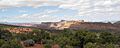
West face of Waterpocket fold – Looking north from Miners Mountain
-
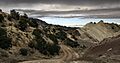
View of tilted Morrison Formation beds along Notom Road, Capitol Reef NP

