
Capitol Reef National Park facts for kids
Quick facts for kids Capitol Reef National Park |
|
|---|---|
|
IUCN Category II (National Park)
|
|

Capitol Reef National Park
|
|

Capitol Reef National Park
Location in the United States

Capitol Reef National Park
Location in Utah
|
|
| Location | Wayne, Garfield, Sevier, and Emery counties, Utah, United States |
| Nearest city | Torrey |
| Area | 241,904 acres (978.95 km2) 670 acres (270 ha) private |
| Established | December 18, 1971 |
| Visitors | 1,227,627 (in 2018) |
| Governing body | National Park Service |
Capitol Reef National Park is a special place in south-central Utah, in the United States. It's about 60 miles (97 km) long from north to south. But it's only about 6 miles (9.7 km) wide on average. The park was created in 1971. Its goal is to protect 241,904 acres (377.98 sq mi; 97,895.08 ha; 978.95 km2) of beautiful desert land. You can visit the park all year round. The busiest times are from May through September.
Local people first called this area "Wayne Wonderland" in the 1920s. This was thanks to Ephraim P. Pectol and Joseph S. Hickman. President Franklin D. Roosevelt made Capitol Reef a national monument in 1937. This protected its colorful canyons, ridges, and tall rock formations. The park officially opened to visitors in 1950. Getting there became easier in 1962. That's when State Route 24 was built through the Fremont River Canyon.
Most of a huge rock formation called the Waterpocket Fold is in the park. This rocky "spine" is nearly 100 mi (160 km) long. It stretches from Thousand Lake Mountain to Lake Powell. Capitol Reef is a very rugged and amazing part of this fold. The park got its name from its white Navajo Sandstone cliffs. These cliffs have dome shapes. They look a bit like the white domes on capitol buildings. The word reef here means a rocky barrier. It's like how ocean reefs block ships.
Contents
Exploring Capitol Reef's Landscape

Capitol Reef National Park is home to the Waterpocket Fold. This is a huge bend in the Earth's crust. It formed about 65 million years ago. It's the biggest exposed monocline (a rock layer bent in one direction) in North America. In this fold, old and new layers of rock bent into an S-shape. This bend was likely caused by the same forces that made the Rocky Mountains. Over millions of years, wind and water wore away the rock. This revealed amazing layers of rock and fossils. The park has bright sandstone cliffs and shiny white domes. It also has many different layers of stone and earth.
The park was named for its white domes and cliffs. These are made of Navajo Sandstone. They look a bit like the United States Capitol building. These formations stretch from the Fremont River to Pleasant Creek.
The Waterpocket Fold creates a natural barrier. Not many roads can cross it. Early settlers called these impassable ridges "reefs." That's where the park gets the second part of its name. The first paved road was built here in 1962. State Route 24 goes through the park from east to west. It connects to Canyonlands National Park and Bryce Canyon National Park. But most of the park is rugged desert.
The park is full of canyons, cliffs, towers, domes, and arches. The Fremont River has carved canyons through the Waterpocket Fold. A scenic drive lets visitors see some of the main sights. But it only goes a few miles from the main highway. Hundreds of miles of trails and unpaved roads lead into the beautiful backcountry.
A Look at Capitol Reef's Past
Early People and Settlers


The Fremont people, Native Americans, lived here around the year 1000. They lived near the Fremont River in the northern part of the park. They used irrigation to grow corn and squash. They stored their grain in stone buildings. These were partly made from black basalt rocks. Around the 1200s, all Native American groups in this area changed. This was probably because of a long dry period. The Fremont settlements were left empty.
Many years later, the Paiute moved into the area. They called the Fremont grain storage buildings moki huts. They believed tiny people lived in them.
In the 1870s, settlers from The Church of Jesus Christ of Latter-day Saints (Mormons) moved into the valleys. They started towns like Loa, Fremont, and Torrey. Mormons settled the Fremont River valley in the 1880s. They created towns like Junction (later called Fruita). Fruita grew well. People farmed and also mined lime and uranium here. The first uranium mine claim was made in 1904.
By 1920, only about ten families lived in Fruita. The area stayed very isolated. Later, the community was left empty. The National Park Service later restored some of the buildings.
Protecting the Land
Local leader Ephraim Portman Pectol worked hard to promote the area. In 1921, he started a "booster club" in Torrey. He sent stories to newspapers and magazines. His brother-in-law, Joseph S. Hickman, helped him. Hickman even organized a club for the whole county.
In 1933, Pectol asked President Franklin D. Roosevelt to make the area a national monument. Federal agencies then studied the land. Pectol guided government workers on many trips. He also showed more and more visitors around.
President Roosevelt signed a paper creating Capitol Reef National Monument on August 2, 1937. This set aside 37,711 acres (15,261 ha) of the area. The Great Depression meant the National Park Service (NPS) had little money. It took a long time for the first park rangers to arrive.
Managing the Monument
Zion National Park managed the new monument. Workers built a stone ranger cabin and a bridge. They also improved some roads. Charles Kelly volunteered to watch over the park. In 1950, he became the first superintendent.
In the 1950s, the U.S. Atomic Energy Commission wanted to mine uranium in the monument. Kelly was worried this would harm the park. It turned out there wasn't enough uranium to be worth mining.
In the 1960s, the NPS built new facilities. This was part of a program called Mission 66. Capitol Reef got a campground, staff housing, and a new visitor center. The visitor center opened in 1966.
More people visited after State Route 24 was paved in 1962. This new road went through the Fremont River canyon. It replaced an old, narrow road that often flooded. In 1967, over 146,000 people visited the park. The park staff also grew.
In 1968, President Lyndon B. Johnson added a huge area of land to the monument. This added 215,056 acres (87,030 ha) more land. By 1970, Capitol Reef National Monument was 254,251 acres (102,892 ha) big. It stretched far to the southeast.
Becoming a National Park

With the monument so much bigger, people wondered if it should become a national park. Two bills were introduced in the United States Congress.
Finally, in late 1971, Congress finished its work. A new bill was introduced by Senator Frank E. Moss of Utah. It called for an even larger Capitol Reef National Park. The House of Representatives also worked on a similar bill. They agreed to a plan where grazing (animals eating plants) would slowly end over 25 years.
The legislation was signed by President Richard Nixon on December 18, 1971. This officially made Capitol Reef a national park.
Weather in Capitol Reef
Capitol Reef has a Cold semi-arid climate. This means it's usually dry, but not a true desert. It can get cold in winter and hot in summer.
| Climate data for Capitol Reef Visitor Center, elevation 5,653 ft (1,723 m), 1981-2010 normals, extremes 1981-2019 | |||||||||||||
|---|---|---|---|---|---|---|---|---|---|---|---|---|---|
| Month | Jan | Feb | Mar | Apr | May | Jun | Jul | Aug | Sep | Oct | Nov | Dec | Year |
| Record high °F (°C) | 58.6 (14.8) |
68.3 (20.2) |
78.3 (25.7) |
84.4 (29.1) |
94.6 (34.8) |
100.2 (37.9) |
100.8 (38.2) |
97.9 (36.6) |
95.4 (35.2) |
86.1 (30.1) |
70.4 (21.3) |
61.5 (16.4) |
100.8 (38.2) |
| Mean daily maximum °F (°C) | 40.6 (4.8) |
46.4 (8.0) |
54.7 (12.6) |
65.0 (18.3) |
74.5 (23.6) |
85.3 (29.6) |
90.4 (32.4) |
87.9 (31.1) |
80.2 (26.8) |
66.1 (18.9) |
51.3 (10.7) |
40.6 (4.8) |
65.3 (18.5) |
| Mean daily minimum °F (°C) | 17.8 (−7.9) |
22.7 (−5.2) |
30.2 (−1.0) |
36.2 (2.3) |
44.7 (7.1) |
53.1 (11.7) |
60.4 (15.8) |
58.5 (14.7) |
50.4 (10.2) |
39.0 (3.9) |
27.6 (−2.4) |
18.2 (−7.7) |
38.3 (3.5) |
| Record low °F (°C) | −4.2 (−20.1) |
−11.8 (−24.3) |
9.1 (−12.7) |
18.1 (−7.7) |
27.2 (−2.7) |
34.6 (1.4) |
42.4 (5.8) |
45.1 (7.3) |
29.9 (−1.2) |
11.7 (−11.3) |
8.0 (−13.3) |
−7.5 (−21.9) |
−11.8 (−24.3) |
| Average precipitation inches (mm) | 0.52 (13) |
0.34 (8.6) |
0.53 (13) |
0.47 (12) |
0.59 (15) |
0.47 (12) |
0.91 (23) |
1.20 (30) |
0.80 (20) |
0.98 (25) |
0.49 (12) |
0.32 (8.1) |
7.62 (194) |
| Average dew point °F (°C) | 17.3 (−8.2) |
20.8 (−6.2) |
23.0 (−5.0) |
24.5 (−4.2) |
29.1 (−1.6) |
32.0 (0.0) |
40.0 (4.4) |
41.8 (5.4) |
34.8 (1.6) |
28.2 (−2.1) |
21.9 (−5.6) |
17.5 (−8.1) |
27.6 (−2.4) |
| Source: PRISM | |||||||||||||
How Capitol Reef's Rocks Formed

Long ago, the area was the edge of a shallow sea. This sea came and went over millions of years. It left behind layers of rock. For example, the Cutler Formation and Kaibab Limestone formed from sea deposits.
Later, during the Triassic period, streams left reddish-brown mud. This became the Moenkopi Formation. Then, the land lifted up and wore away. Next, layers of sand, mud, and volcanic ash formed. This created the uranium-rich Chinle Formation.
The Glen Canyon Group layers formed during a very dry time. These include:
- Wingate Sandstone: From ancient sand dunes near a sea.
- Kayenta Formation: Thin layers of sand from slow-moving streams.
- Navajo Sandstone: Huge fossilized sand dunes from a giant desert.

The San Rafael Group has four layers from the Jurassic period:
- Carmel Formation: gypsum, sand, and limey mud from a sea.
- Entrada Sandstone: Sandstone from sandbars near the coast.
- Curtis Formation: Made of gravel, sand, and mudstone.
- Summerville Formation: Reddish-brown mud and white sand from tidal flats.
Streams then laid down more mud and sand. This formed the Morrison Formation. Later, similar sediments created the Dakota Sandstone. Eventually, a large sea covered the land. It deposited the Mancos Shale.
Near the end of the Cretaceous period, mountains began to form. This event created the Rocky Mountains. It also made bends in the rock like the Waterpocket Fold. Millions of years ago, the whole area lifted up. This formed the Colorado Plateau. Volcanism also happened during this time.
The rivers and streams changed course and flowed faster. This caused them to carve deeper into the land. During the ice ages, wetter weather increased how fast the land wore away.
Visiting the Park
The closest town to Capitol Reef is Torrey. It's about 11 mi (18 km) west of the visitor center. Torrey is a small town with places to stay and eat. You can also reach the park from the west using Highway 12. Another way is the Burr Trail, a partly unpaved road.
Fun Things to Do
There are many activities for visitors at Capitol Reef. You can explore on your own or with a park ranger. These include driving tours, hiking, backpacking, and camping. You can also bike on roads, ride horses, or go canyoneering.
The park maintains old fruit orchards planted by early settlers. From March to October, you can pick different fruits. These include cherries, apricots, peaches, pears, or apples. You pay a small fee for the fruit you pick.
Hiking and Backpacking Adventures

The visitor center has guides for hiking trails. You can do short day hikes or longer backpacking trips. If you want to go backpacking, you need a free permit.
Here are some popular trails:
- Cassidy Arch Trail: A tough 3.5 mi (5.6 km) round trip. It leads to a view of Cassidy Arch.
- Hickman Bridge Trail: An easier 2 mi (3.2 km) round trip. It takes you to a beautiful natural bridge.
- Frying Pan Trail: An 8.8 mi (14.2 km) round trip. It passes Cassidy Arch, Grand Wash, and Cohab Canyon.
- Brimhall Natural Bridge: A popular but tough 4.5 mi (7.2 km) round trip. It offers views of Brimhall Canyon and the Waterpocket Fold.
- Halls Creek Narrows: This trail is 22 mi (35 km) long and very challenging. It has many side canyons and creeks. Most people hike it as a 2-3 day camping trip.
Driving Through the Park
You can explore several main areas of the park by car:
- Scenic Drive: This road winds through the middle of the park. It passes many interesting spots. You can access it from the visitor center.
- Notom-Bullfrog Road: This road goes along the eastern side of the Waterpocket Fold. About 10 mi (16 km) are paved, and the rest is unpaved.
- Cathedral Road: This is an unpaved road in the northern part of the park. It goes through Cathedral Valley. You can see the Temples of the Sun and Moon here.
Camping Under the Stars
The main camping spot is the Fruita campground. It has 71 campsites. These sites do not have water, electricity, or sewer hookups. Restrooms are available, but there are no showers. The campground also has group sites for larger groups. There are also two free, basic camping areas available.
Images for kids
-
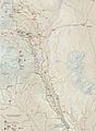
Park map
-
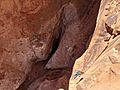
Taken from the top of the first rappel of the Cassidy Arch route.

.jpg)
