
Utah State Route 12 facts for kids
Quick facts for kids
|
||||
|---|---|---|---|---|
| A Journey Through Time Scenic Byway | ||||
|
SR-12 highlighted in red
|
||||
| Route information | ||||
| Defined by Utah Code §72-4-107 | ||||
| Maintained by UDOT | ||||
| Length | 122.863 mi (197.729 km) | |||
| Existed | 1914 as a state highway; 1920s as SR-12–present | |||
| Tourist routes |
||||
| Major junctions | ||||
| West end | ||||
|
||||
| East end | ||||
| Location | ||||
| Counties: | Garfield, Wayne | |||
| Highway system | ||||
| State highways in Utah Interstate • US • State
|
||||

State Route 12, also known as Scenic Byway 12 (SR-12), is an amazing road in Utah. People also call it "Highway 12 — A Journey Through Time Scenic Byway." It's about 123 miles (nearly 200 kilometers) long. This special road has been named an All-American Road because of its incredible views and history. It winds through Garfield County and Wayne County in Utah, United States.
Contents
Exploring Scenic Byway 12

This exciting highway stretches for 123 miles, going from west to east. It begins south of Panguitch where it meets US-89. From there, your adventure truly begins!
The road takes you through parts of the beautiful Dixie National Forest. You'll also get to see the famous Bryce Canyon National Park. Imagine seeing those unique, colorful rock formations!
Towns and Landmarks Along the Way
As you drive, you'll pass through charming small towns. These include Tropic, Cannonville, and Henrieville. The highway also crosses different parts of the huge Grand Staircase–Escalante National Monument. This area has stunning landscapes and ancient history.
You'll continue northeast through Escalante and cross the Escalante River. Get ready for an exciting part called "The Hogback." This is a narrow ridge with steep drop-offs on both sides. It's a thrilling drive with no guardrails!
The road then heads north through more of the Grand Staircase–Escalante National Monument. It passes through Boulder and the Aquarius Plateau. Finally, it goes through Grover. The journey ends in Torrey where it meets SR-24. This is just five miles (8 km) west of Capitol Reef National Park.
Boulder Mountain Highway
A special part of SR-12 is called the Boulder Mountain Highway. This section is about 30 miles (48 km) long. It climbs up and down Boulder Mountain on the Aquarius Plateau. It offers some of the most amazing views on the entire route.
The History of SR-12

The story of this road began a long time ago. In 1914, the road from Bryce Canyon Junction to Tropic became part of Utah's state highway system. Later, in the 1920s, the road to Bryce Canyon was officially named SR-12.
Over the years, different parts of the road were added and connected. This helped people travel to more places. By 1969, many of these smaller roads were combined. This created the longer SR-12 we know today. It stretched from Bryce Canyon Junction all the way to Boulder.
Later, in 1985, the route was extended even further north from Boulder to SR-24. This made it the complete scenic byway that so many people enjoy exploring today. It truly is a journey through time, connecting many important and beautiful places in Utah.
Gallery
-
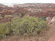
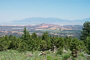
SR-12 goes north up the canyon in the upper left of the photo after crossing the Escalante River. -
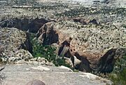
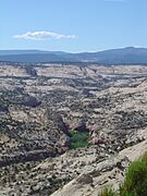
The canyons after the Escalante River. -
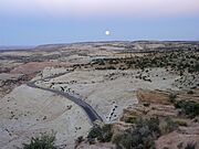
Moonrise over SR-12 in Grand Staircase–Escalante National Monument -
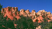
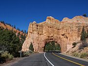
Red Canyon, in Utah's Dixie National Forest, is near the western end of Route 12. -
An overlook from the eastern portion of Highway 12. -
Calf Creek Canyon runs near Route 12. -
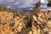
The bridge on Hell's Backbone Road. -
Red Canyon Scenic Drive. -
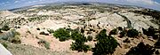
State Route 12 in Utah - Panorama looking north and east from Head of the Rocks Overlook.


