Torrey, Utah facts for kids
Quick facts for kids
Torrey, Utah
|
|
|---|---|

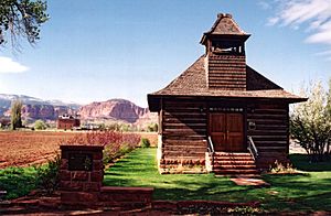
A Utah historic site, this old log schoolhouse with its bell tower and red sandstone steps is a reminder of Torrey's pioneer heritage.
|
|

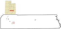
Location in Wayne County and the state of Utah.
|
|
| Country | United States |
| State | Utah |
| County | Wayne |
| Incorporated | 1934 |
| Named for | Jay Torrey |
| Area | |
| • Total | 1.66 sq mi (4.31 km2) |
| • Land | 1.66 sq mi (4.31 km2) |
| • Water | 0.00 sq mi (0.00 km2) |
| Elevation | 6,837 ft (2,084 m) |
| Population
(2010)
|
|
| • Total | 182 |
| • Estimate
(2019)
|
244 |
| • Density | 146.63/sq mi (56.61/km2) |
| Time zone | UTC-7 (Mountain (MST)) |
| • Summer (DST) | UTC-6 (MDT) |
| ZIP code |
84775
|
| Area code(s) | 435 |
| FIPS code | 49-77010 |
Torrey is a small town in Utah, United States. It is located in Wayne County, right on State Route 24. Torrey is only about 8 miles (13 km) away from the beautiful Capitol Reef National Park. In 2010, about 182 people lived in Torrey.
History of Torrey
Torrey was started in the 1880s. Settlers from the Church of Jesus Christ of Latter-day Saints built the town. At first, it was called Youngtown. This name honored John Willard Young.
The town is now named after Jay L. Torrey. He was from Pittsfield, Illinois. Jay Torrey was a member of the Wyoming legislature. During the Spanish–American War, he became famous. He suggested creating three groups of volunteer cavalry soldiers. These groups were made up of cowboys and stockmen. Torrey became a colonel in the 2nd Regiment, known as the "Rocky Mountain Riders."
Geography and Location
Torrey is found on the north side of the Fremont River. To the southwest, you can see Boulder Mountain. To the east is Capitol Reef National Park.
Other nearby towns include Teasdale, about three miles (4.8 km) southwest. Grover is about five miles (8 km) southeast. Bicknell is about six miles (9.7 km) northwest. The main roads serving Torrey are Utah State Route 24 and Utah State Route 12.
The United States Census Bureau says that Torrey covers about 1.3 square miles (3.4 km2). All of this area is land.
People of Torrey
| Historical population | |||
|---|---|---|---|
| Census | Pop. | %± | |
| 1910 | 142 | — | |
| 1920 | 252 | 77.5% | |
| 1930 | 274 | 8.7% | |
| 1940 | 241 | −12.0% | |
| 1950 | 241 | 0.0% | |
| 1960 | 128 | −46.9% | |
| 1970 | 84 | −34.4% | |
| 1980 | 140 | 66.7% | |
| 1990 | 122 | −12.9% | |
| 2000 | 171 | 40.2% | |
| 2010 | 182 | 6.4% | |
| 2019 (est.) | 244 | 34.1% | |
| U.S. Decennial Census | |||
In 2000, there were 171 people living in Torrey. There were 73 households and 50 families. The town had about 433 people per square mile (169 per km2). Most people living in Torrey were White. A small number were of Hispanic or Latino background.
About 23% of households had children under 18. Most households (56%) were married couples. The average household had 2.34 people. The average family had 2.76 people.
The population was spread out by age. About 21.6% were under 18. About 22.8% were 65 or older. The average age in Torrey was 43 years old.
See also
 In Spanish: Torrey (Utah) para niños
 | Percy Lavon Julian |
 | Katherine Johnson |
 | George Washington Carver |
 | Annie Easley |

